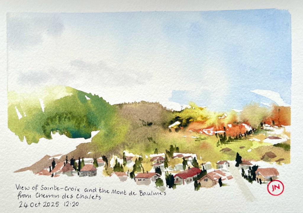
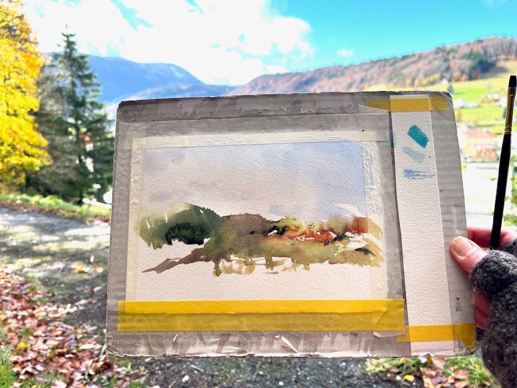
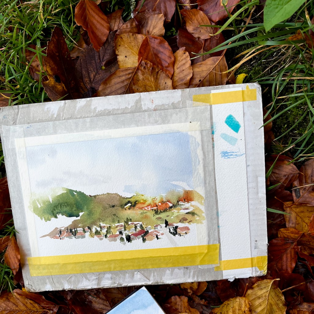
Here is a autumn scene in Sainte-Croix in the canton of Vaud, Switzerland.
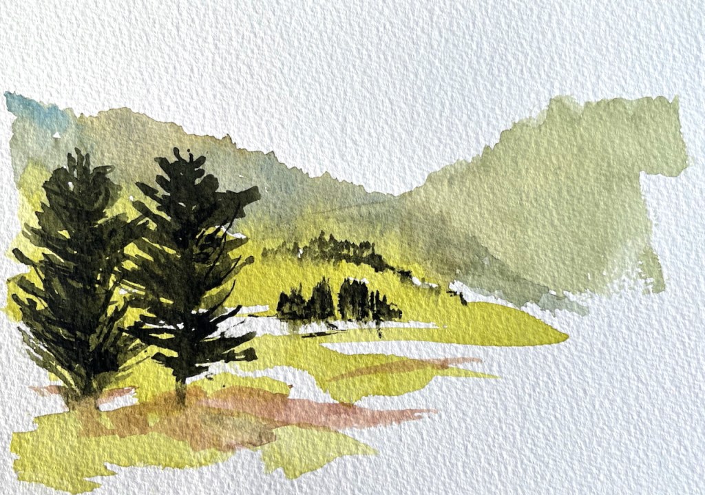
View over Sainte-Croix and the Mont de Baulmes, from Chemin des ChaletsWork in progress on the sketch
I sketched also in the village.
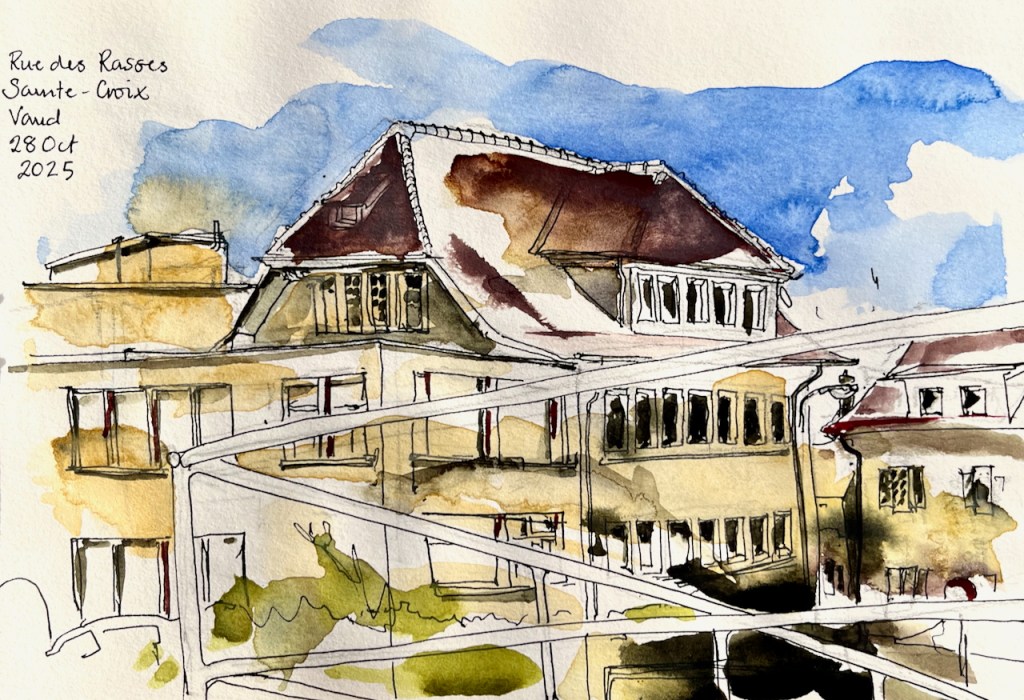
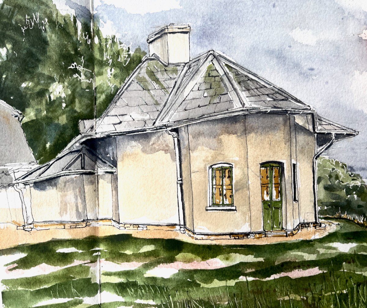
House, Rue des Rasses, Sainte-Croix
It is a season of clouds.
Jura scenes
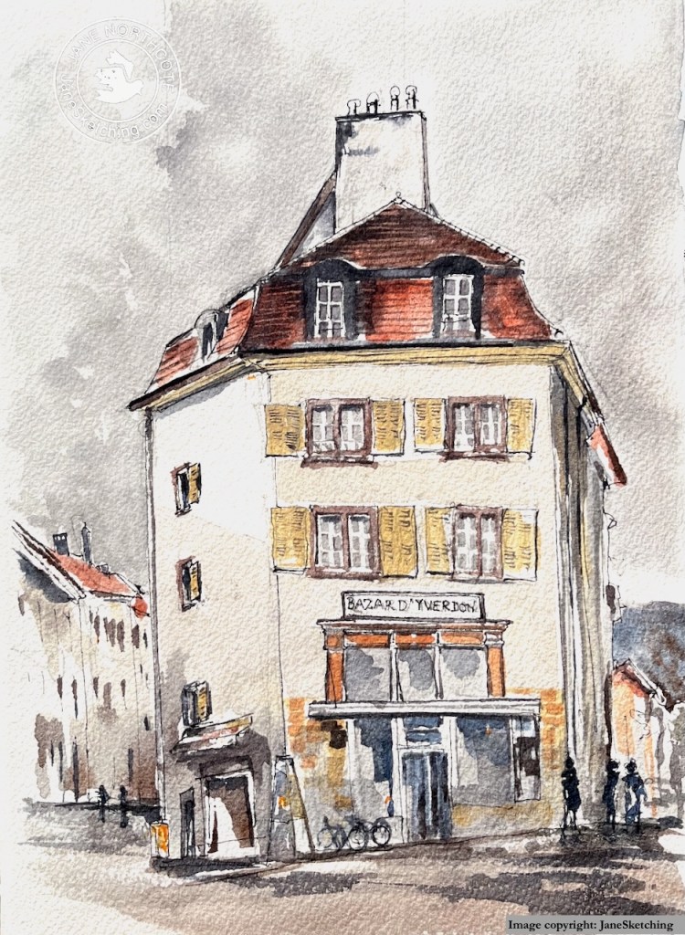
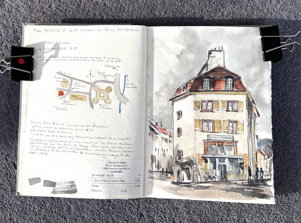
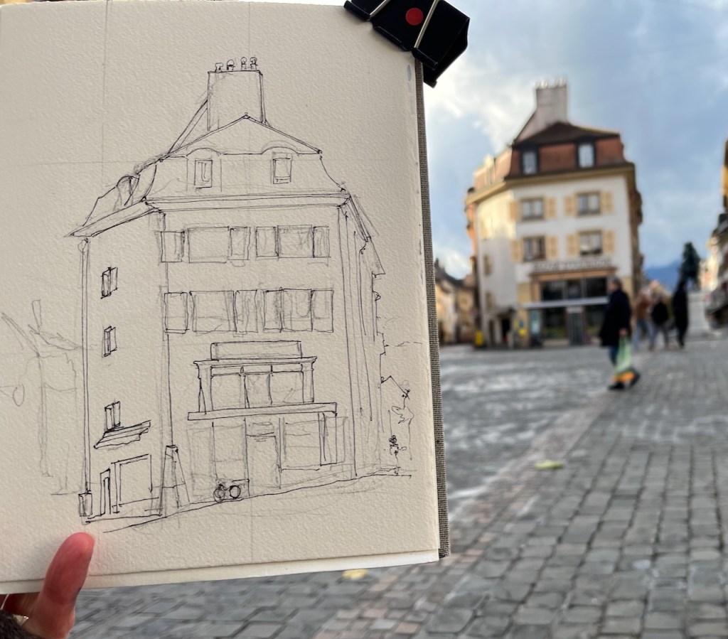
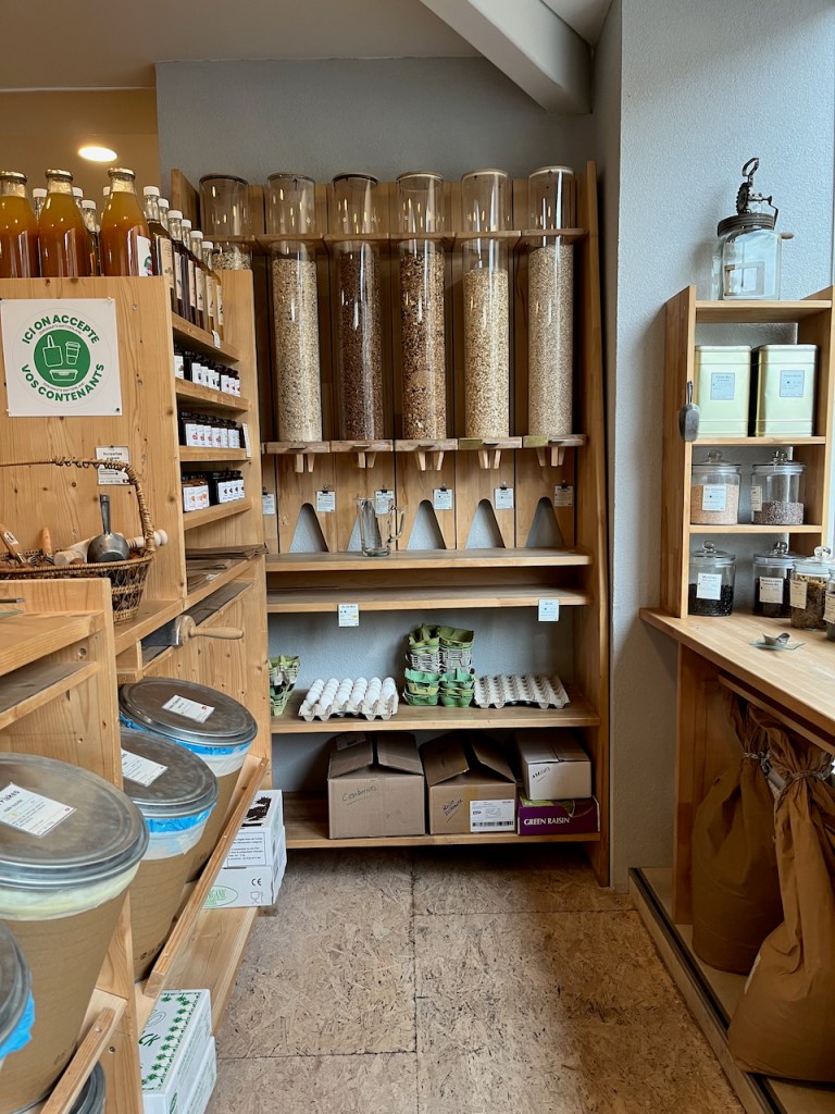
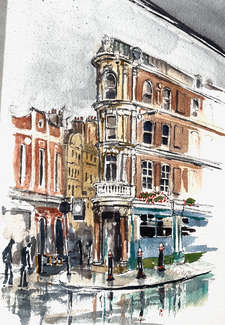
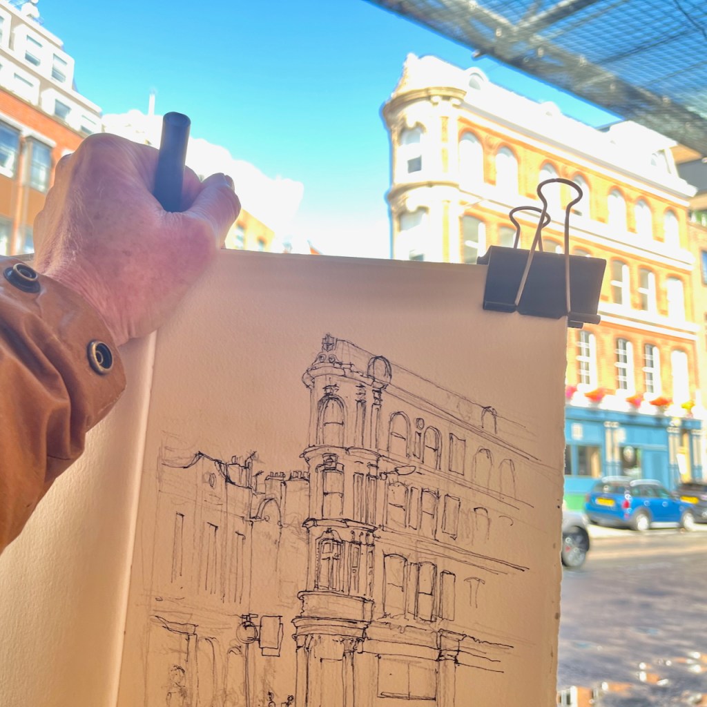
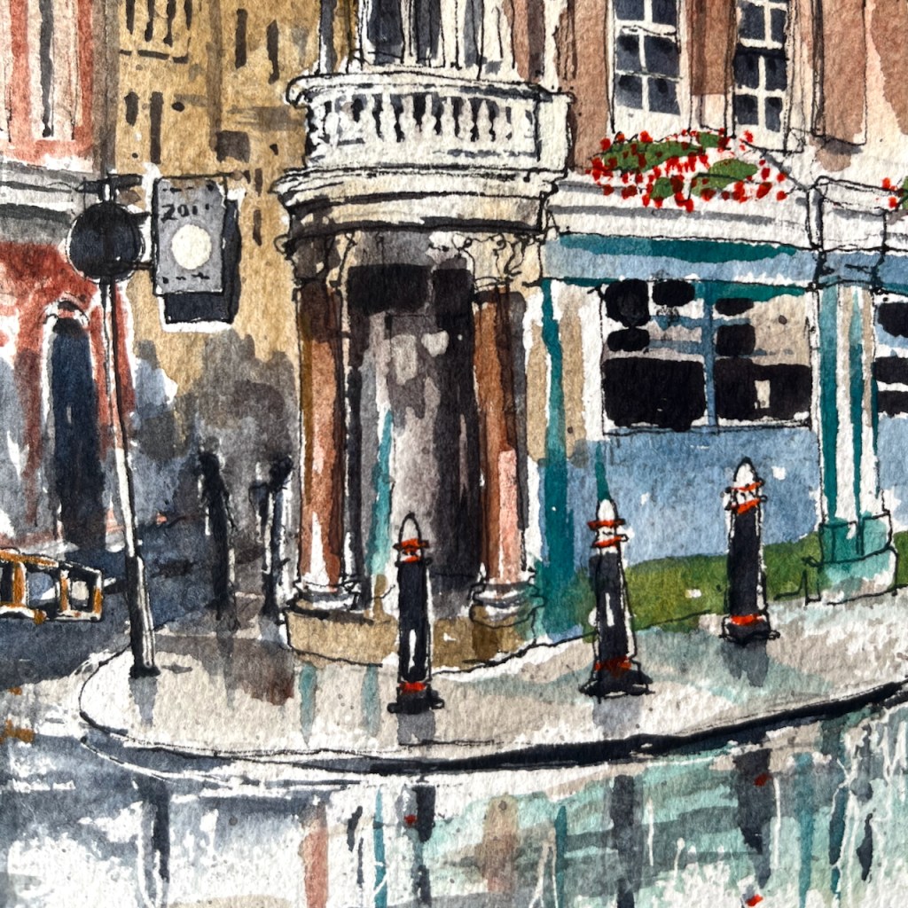
On an expedition to Yverdon-les-Bains I sketched in the Place Pestalozzi.
Bazar D’Yverdon, now L’Epicerie Vrac, Place Pestalozzi 3 1400 Yverdon-les-Bains
It was very cold. I just managed to complete the pen and ink sitting in the square. Then I finished the colour in my hotel room.
This building, Bazar D’Yverdon, dates from the beginning of the 17th century. There is an article in the local paper of 2018 (note 1), with some history of the building, and news of a campaign to prevent its being sold and transformed from a retail space into offices. At the time is was a stationary shop, Papeterie Schaer.
A bazaar is a souk, a living place where there are goods and services, where you gossip, trade. For us, the very name “Bazar” is a real source of inspiration.”
Aurélie Massin-Kerkan, co-president of the association for maintaining usage of the Bazar (note 1 – my translation)
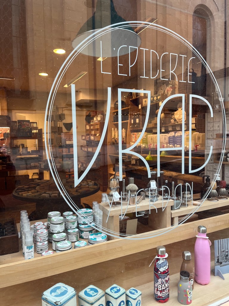
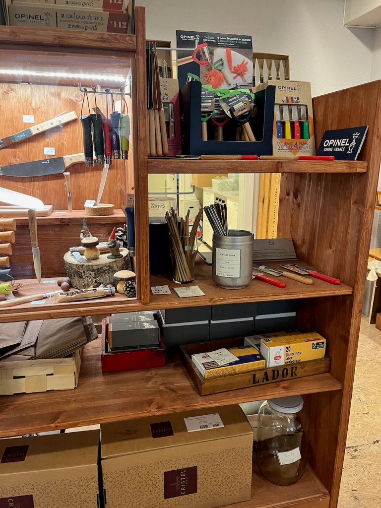
Evidently the campaign was successful. The shop on the ground floor is now a grocer “L’Épicerie VRAC”. I went in to have a look. It sells bulk household goods such as shampoo and muesli, as well as a huge collection of traditional items such as egg timers and kitchen knives and tea towels. The bulk items are displayed in dispensers, so you can fill your own container.
L’Épicerie VRAC
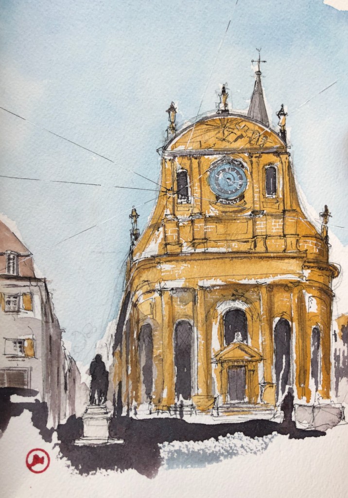
I’ve sketched in Yverdon before. Here is the Temple of Yverdon which is just to the right of the Bazar.
Temple d’Yverdon. The Bazar is the building on the left of this sketch. Click to go to my article about the Temple.
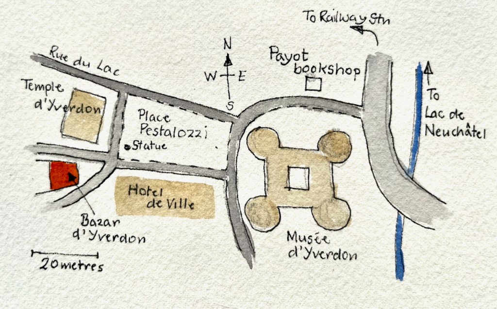
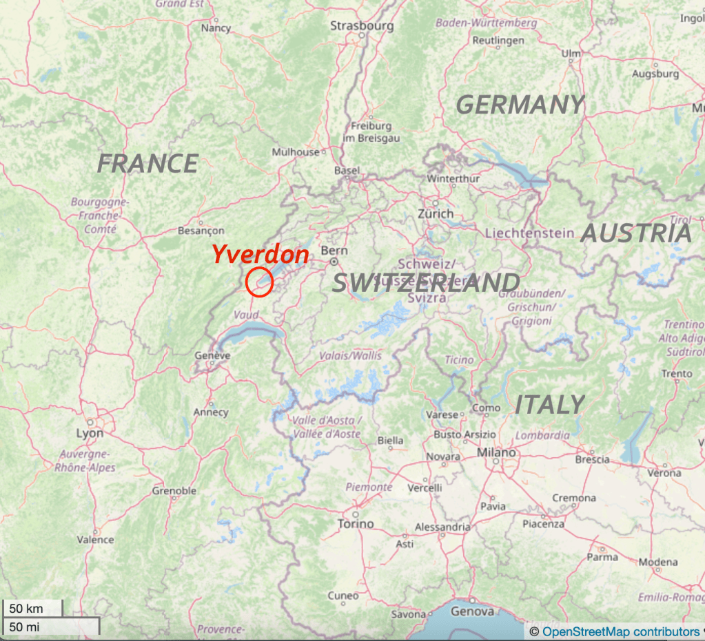
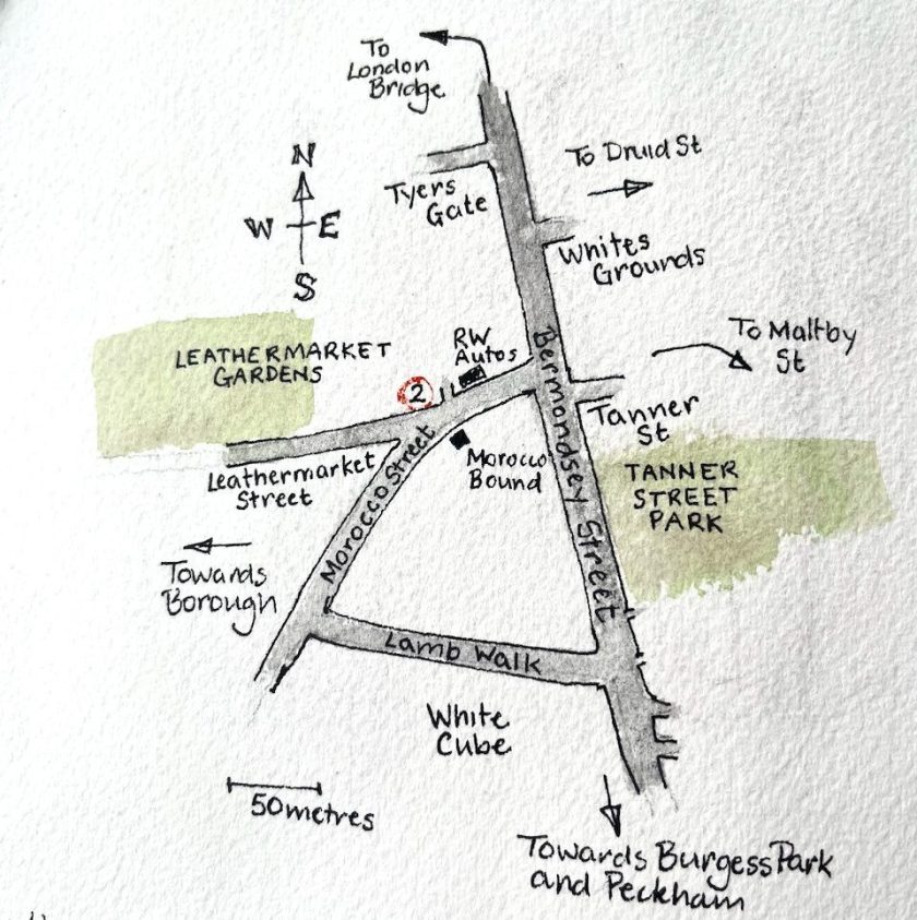
The maps below show the location of Yverdon, in the canton of Vaud.
Canton of Vaud is in the West of SwitzerlandLocation of Yverdon (c) OpenStreetMap contributors
On the Place Pestalozzi
Note 1: The local paper article about the Bazar is in the archives of “24 heures – VAUD”. It is by Frederick Ravissin, 16 June 2018. Read a pdf of the article here (in French) – link below:
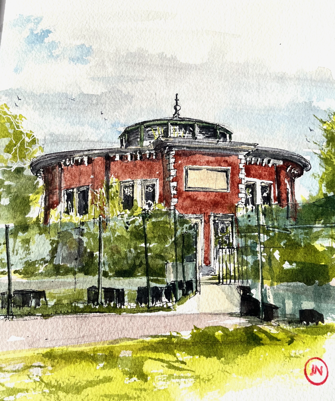
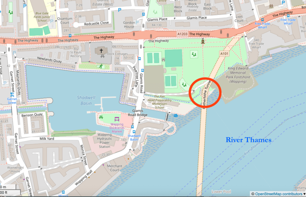
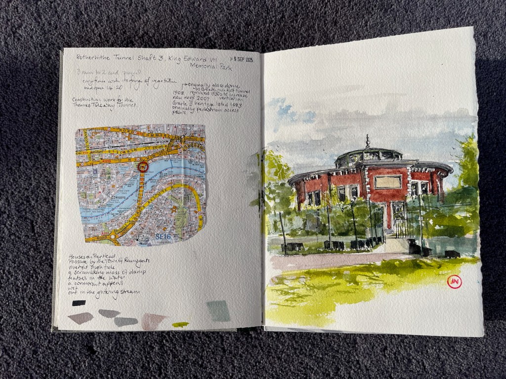
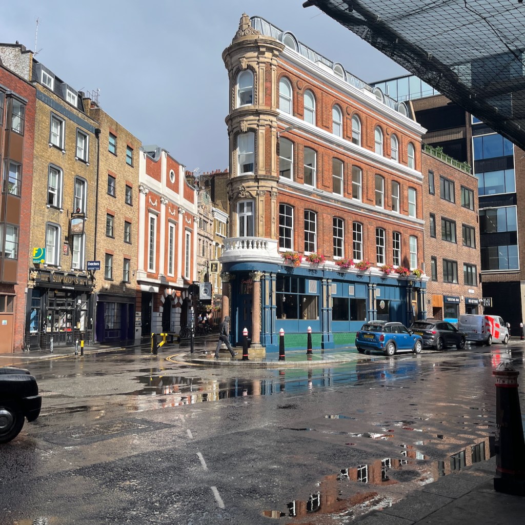
Construction work for the Thames Tideway tunnel surrounds this small round building on the north side of the Thames, near Shadwell.
Rotherhithe Tunnel Shaft 3, King Edward VII Memorial Park, sketched 9th September 2025 in Sketchbook 16
This building is an air shaft and access point access for the Rotherhithe tunnel. The Rotherhithe Tunnel carries road traffic between Rotherhithe on the south of the river and Limehouse on the north. It was constructed between 1904 and 1908, for horses and carts. The designer was Sir Maurice Fitzmaurice.
The tunnel links Limehouse on the north of the river to Rotherhithe on the south. Built originally for horse-drawn carriages and pedestrians, the tunnel now carries far more traffic than it was designed for, which requires careful day to day management by TfL to ensure safety.
This circular building is one of four shafts giving access to the tunnel. It contains a spiral staircase, which was in use from when the tunnel was opened in 1908 until the 1970s2. This access is now closed to the public. The shaft building and the staircase are Grade II listed3.
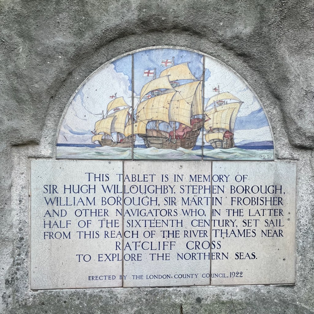
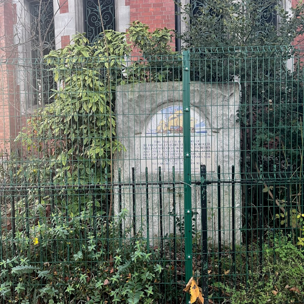
Next to the shaft there is a stone tablet:
THIS TABLET IS IN MEMORY OF SIR HUGH WILLOUGHBY, STEPHEN BOROUGH, WILLIAM BOROUGH, SIR MARTIN FROBISHER AND OTHER NAVIGATORS WHO, IN THE LATTER HALF OF THE SIXTEENTH CENTURY, SET SAIL FROM THIS REACH OF THE RIVER THAMES NEAR RATCLIFF CROSS TO EXPLORE THE NORTHERN SEAS. ERECTED BY THE LONDON. COUNTY COUNCIL, 1922
The roof in my picture dates from a refurbishment in 20074. Originally there was a glass dome5.
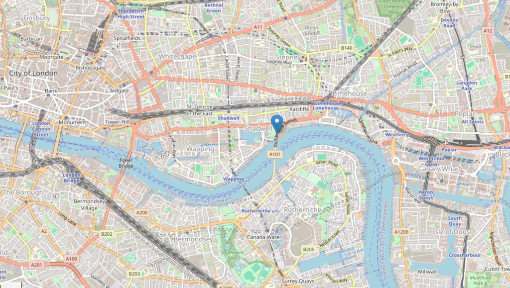
Location of Rotherhithe Tunnel Shaft 3, map (c) OpenStreetMap contributors.
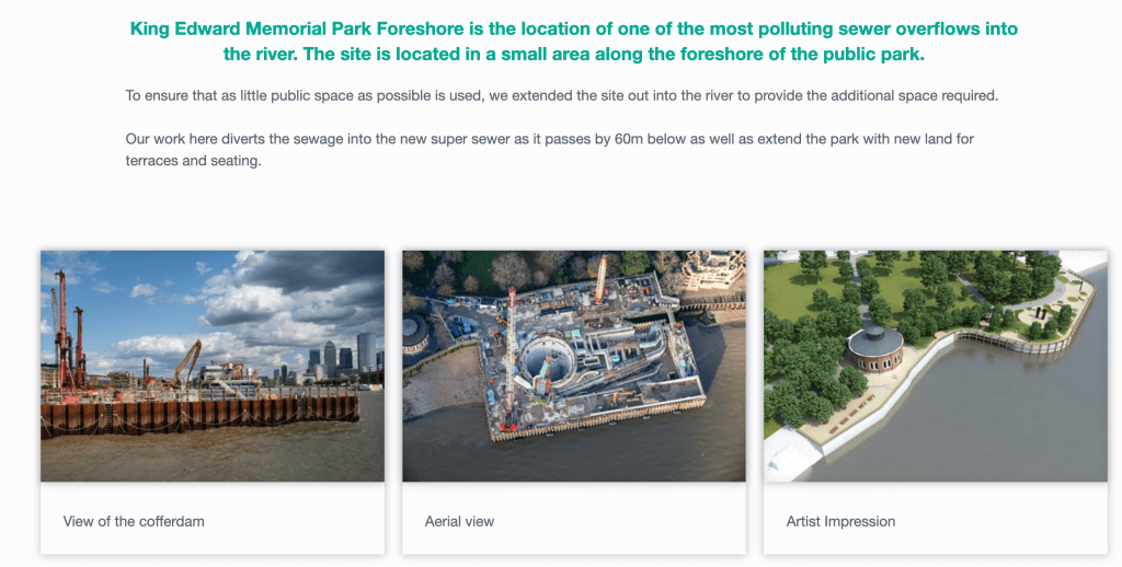
The fences in my drawing are the perimeter of a Thames Tideway tunnel construction site. The Thames Tideway Tunnel carries sewage from central London to Becton Sewage Treatment Works. It runs under the Thames. At various points there is a junction between this main sewer and a local sewerage system. The site at King Edward VII is one such junction.
The Thames Tideway tunnel runs longitudinally along the Thames, so it crosses the Rotherhithe tunnel, which goes across the Thames. But this is not a problem, as the Thames Tideway tunnel is 60m6 below the Thames and the Rotherhithe tunnel is just 23m down7. So they do not bump into each other.
Map showing the position of Shaft 3 at the North end of the Rotherhithe Tunnel. (c) OpenStreetMap Contributors.Sketchbook 16 spread
I’ve read that you can walk through the Rotherhithe Tunnel starting from one of the the tunnel entrances and passing under the shaft I’ve drawn. Those who have tried it8, even during the pandemic, do not recommend the experience. The tunnel is highly polluted from the vehicle fumes, and the pavement is narrow. It’s even pretty terrifying to drive through it in a car. Close the windows and the air vents, and stay alert while driving. If you’d like to walk a Thames tunnel, I recommend the Greenwich Foot Tunnel, or the Woolwich Foot tunnel, both of which I’ve walked. They are fun, eerie and have no traffic to pollute the air. You can read about my excursion to the Woolwich Foot Tunnel here.
Disambiguation: The Rotherhithe Tunnel I’m talking about in this post is not the same as an earlier tunnel built between 1825 and 1843 by Marc Brunel, and his son, Isambard. This Brunel tunnel was a little further upstream, and is now used as a railway tunnel only.
Roof replacement 2007 confirmed by King Edward VII park “Management Plan” 2008 page 15: “The park surrounds the tunnel vent and access shaft to the Rotherhithe Tunnel. The tunnel was opened in 1908, the vent was present before the park was constructed, and early images of the park show that it visually dominated the site. The tunnel vent remains an important feature, but is no longer so visually dominant due to the present day maturity of trees in the park. The Rotherhithe Tunnel was refurbished in 2007 and a replacement roof was installed as part of these works.” Link: https://www.towerhamlets.gov.uk/Documents/Leisure-and-culture/Parks-and-open-spaces/king-edward-management-plan.pdf↩︎
Roof of the shaft: 1908 – glass dome, by 1946 – no roof (removed in the 1930s), from 2007 – current roof as in my drawing. Evidence: London Picture Archive has a picture of the shaft in 1921, where you can see the glass dome that covered the shaft. Record number 118817, Catalogue number SC_PHL_01_392_A360 See this link: https://www.londonpicturearchive.org.uk/view-item?WINID=1762114518393&i=121045. They also have photographs from 1971 where it’s clear that the roof has been removed completely. See photo on this link, record number 237845, catalogue number SC_PHL_02_0666_71_35_217_30A: https://www.londonpicturearchive.org.uk/view-item?i=239938 “A London Inheritance” post contains an aerial picture from 1946 showing that the roof had been removed by that date. See this link. This post says: ” The following photo dated 1946 from Britain from Above shows the park at lower left. Note the round access shaft to the Rotherhithe tunnel. In the photo the shaft has no roof. The original glass roof was removed in the 1930s to improve ventilation. The current roof was installed in 2007.” ↩︎
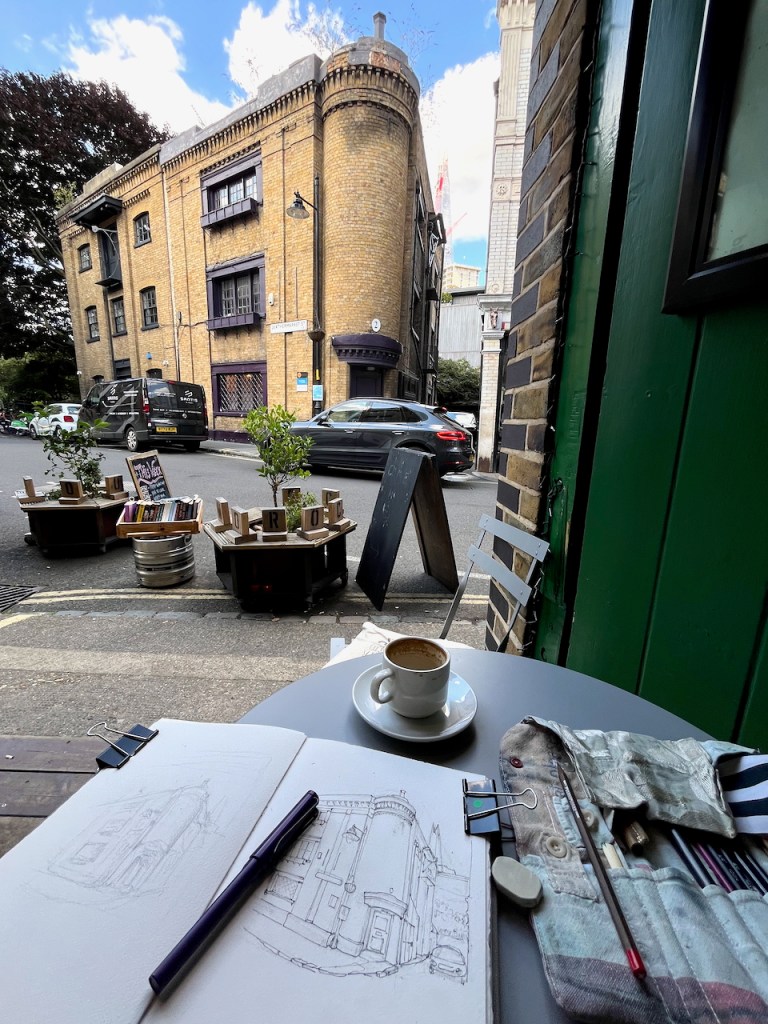
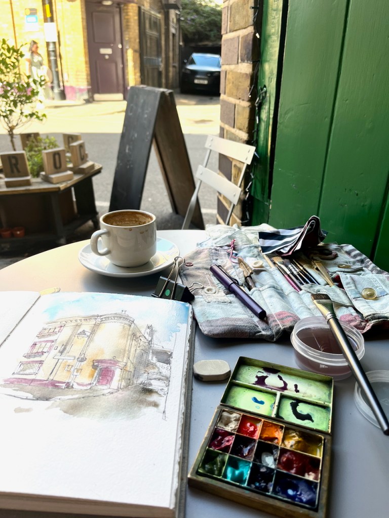
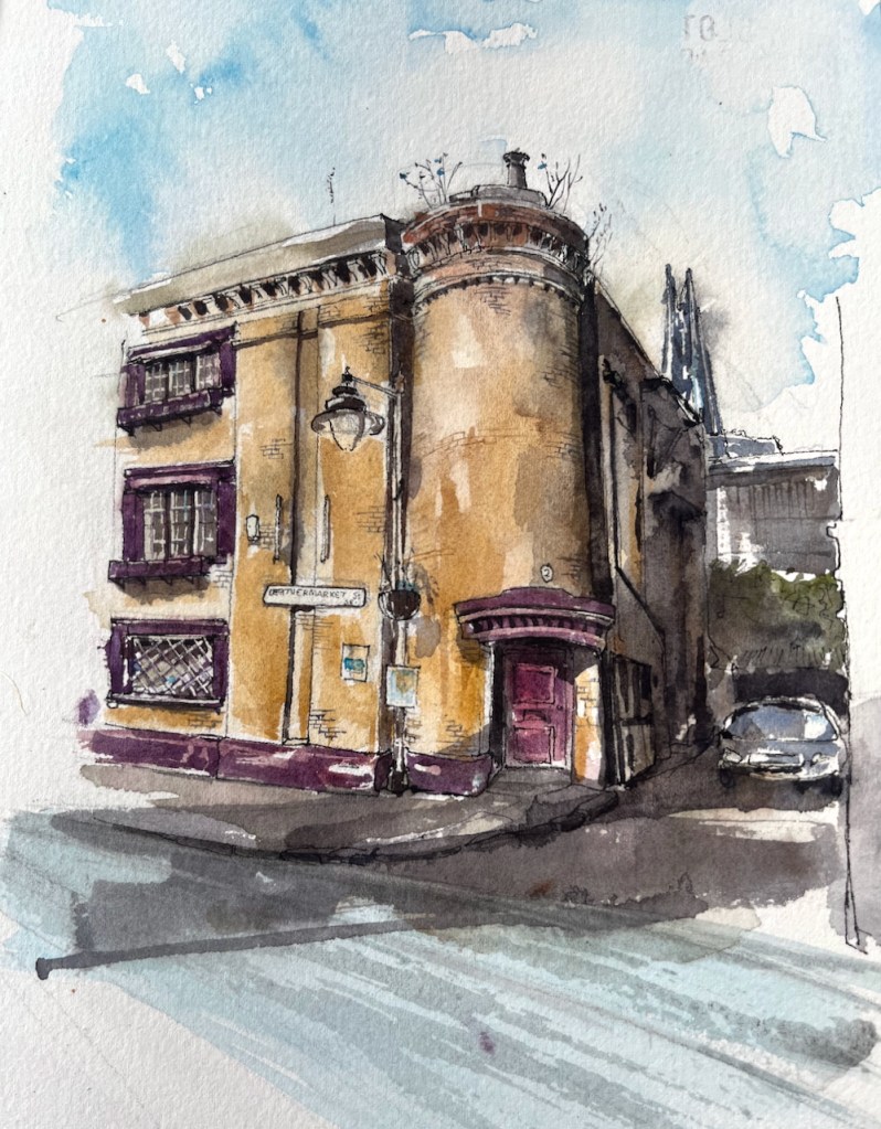
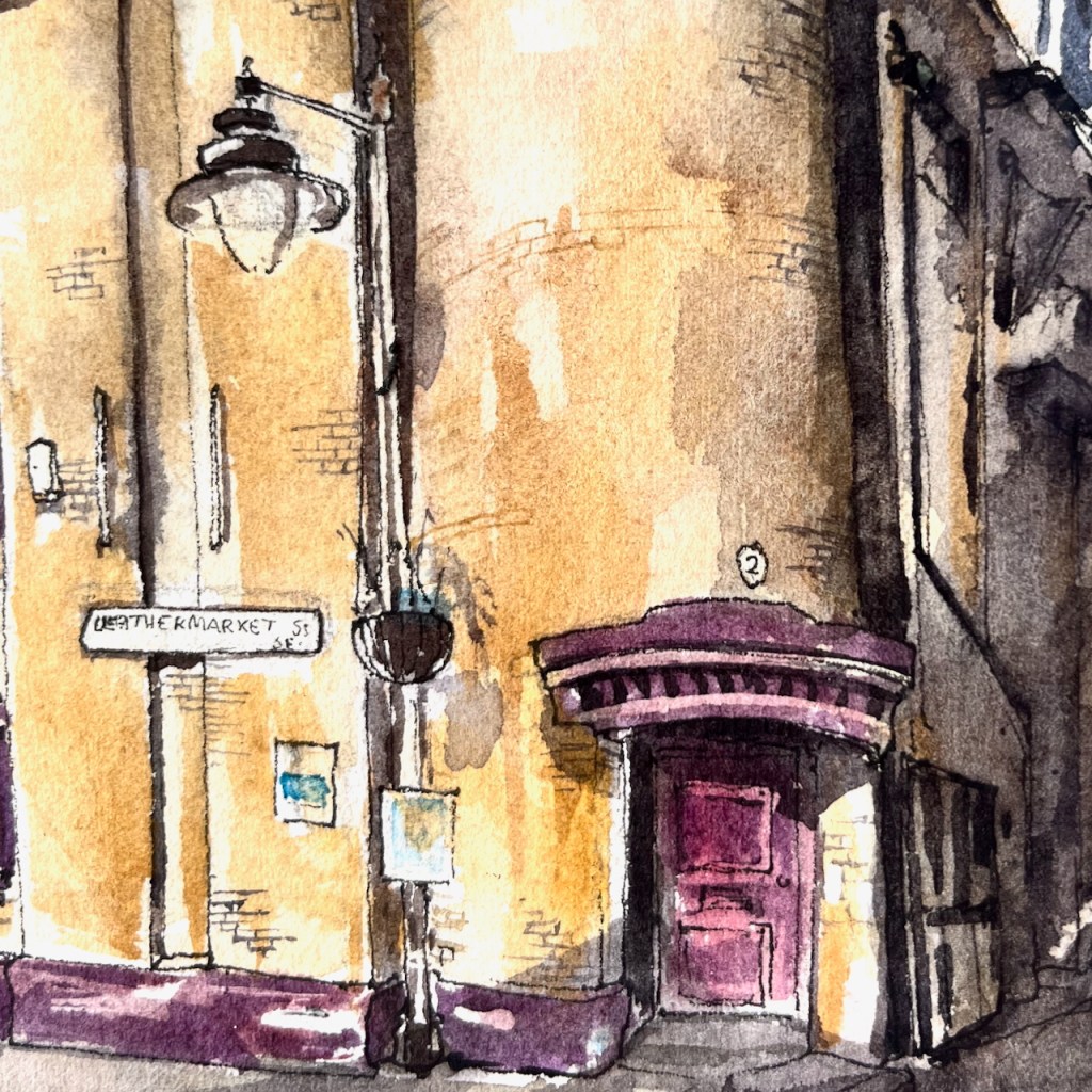
From the café “Morocco Bound” I sketched the distinctive building across the street.
This is 2 Leathermarket Street:
2 Leathermarket Street, London SE1 3HN. Sketched 5th September 2025 in Sketchbook 16
In the distance you see The Shard, at London Bridge Station.
This was the leathermaking district up to the beginning of the twentieth century. We have Leathermarket St, Morocco St, and Tanner St. The former “Leather Hide and Wool Exchange” is further up Leathermarket Street, towards Borough, to the west.
The building was listed Grade II in 1972. It is early 19th century, according to the listing.
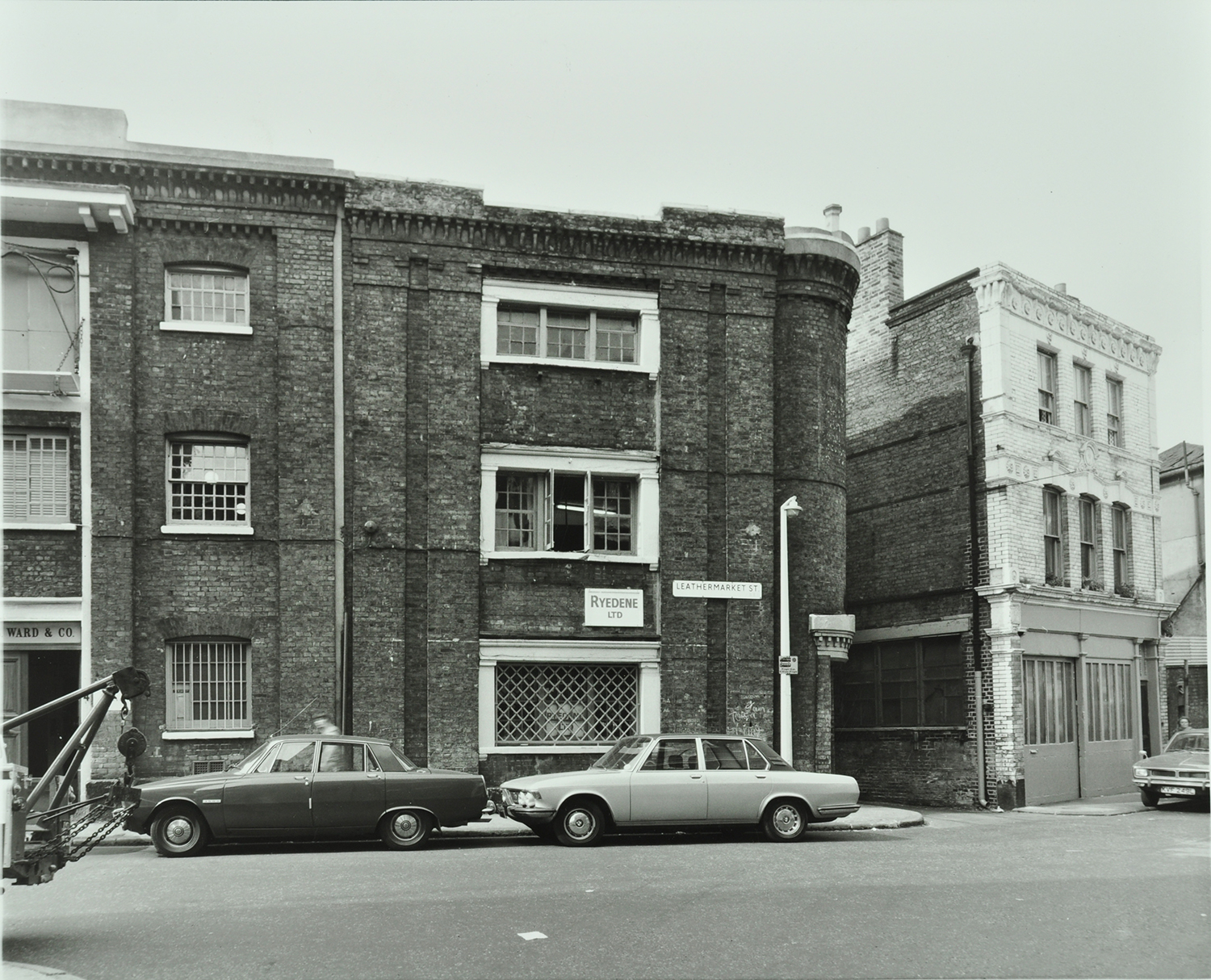
Here is the area in 1976, in a picture from the London Archives, used with permission:
The windows are all still there as in 1976, with the same window frames, now painted purple. Even the weird little chimneypot on the top of the turret is still there, as it was 50 years ago. In this 1976 picture the placard between the windows says “Ryedene Ltd” but I have been unable to discover if this company was in the leather business. There is no placard now.
“The Department” now occupies this building. Their business, according to their website, is:
combining cutting edge technology with humanising theatrics to create experiences which are technically masterful and purposely human”
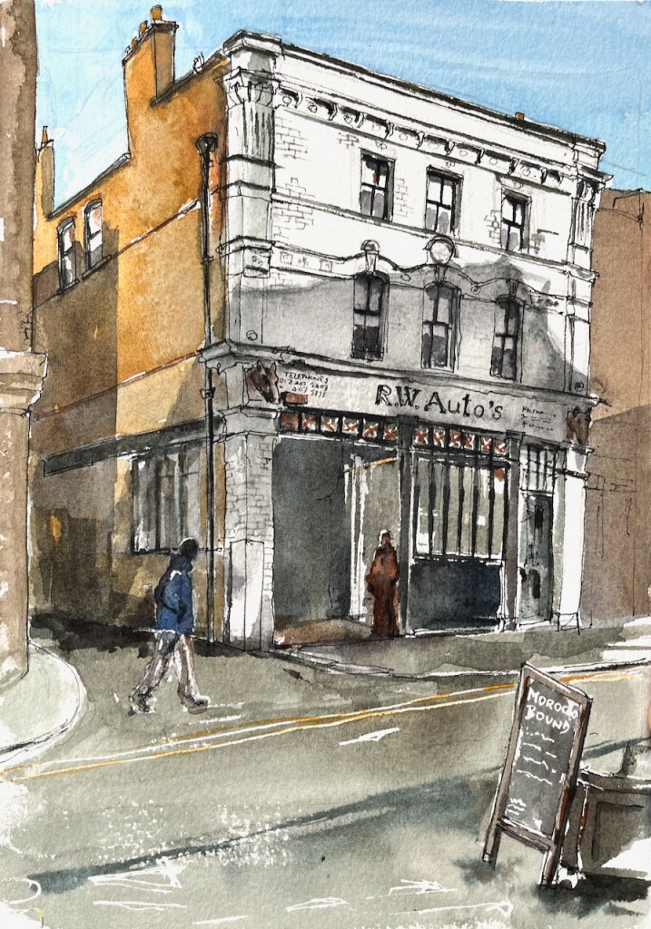
To the right of 2 Leathermarket Street is a garage, “R.W. Auto’s” which I have sketched previously:
2 Morocco Street, sketched from “Morocco Bound”, 18th October 2024, 2pm in Sketchbook 15
Thank you to “Morocco Bound” for their hospitality while I sketched these pictures. It’s a calm and welcoming bookshop and café in an interesting location. I’ll be back!
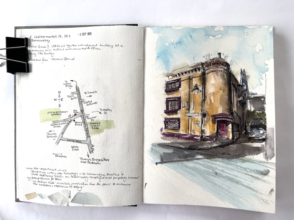
Page spread, Sketchbook 16
Click a button below to share this post online, email it, or print it:
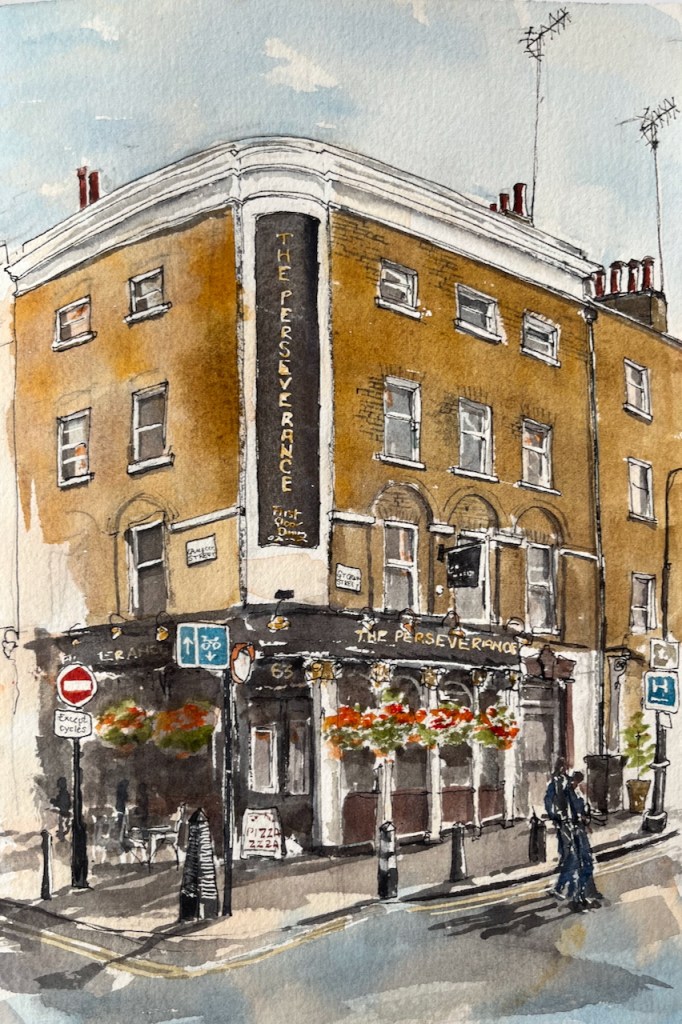
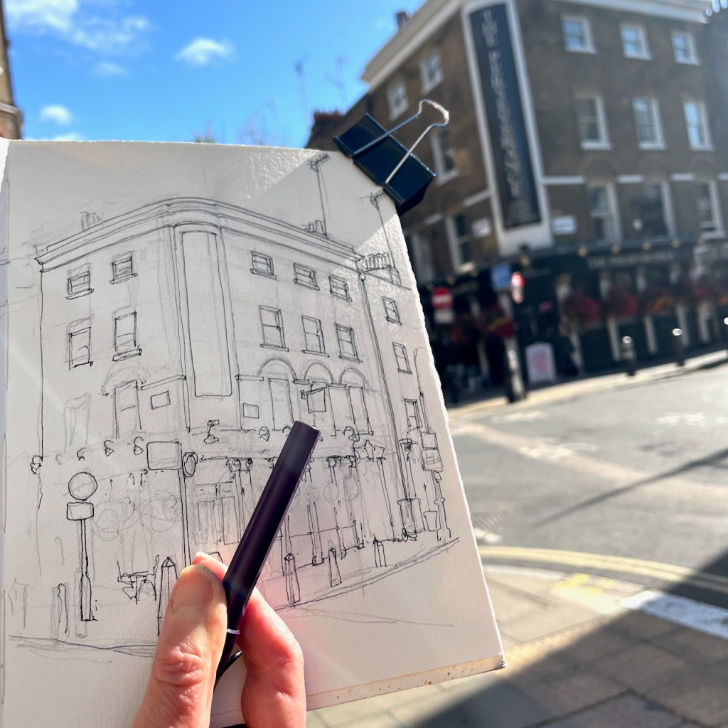
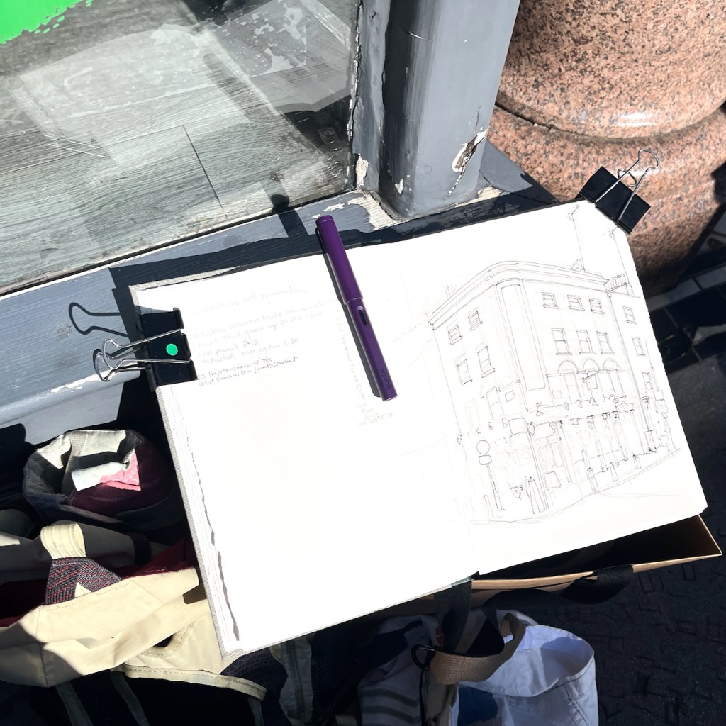
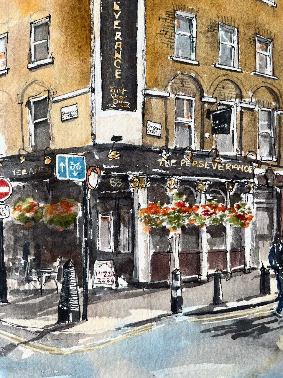
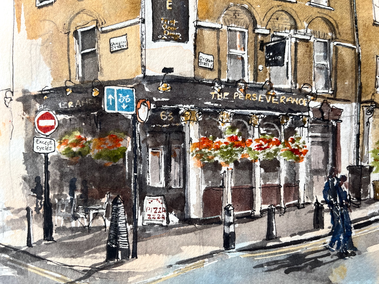
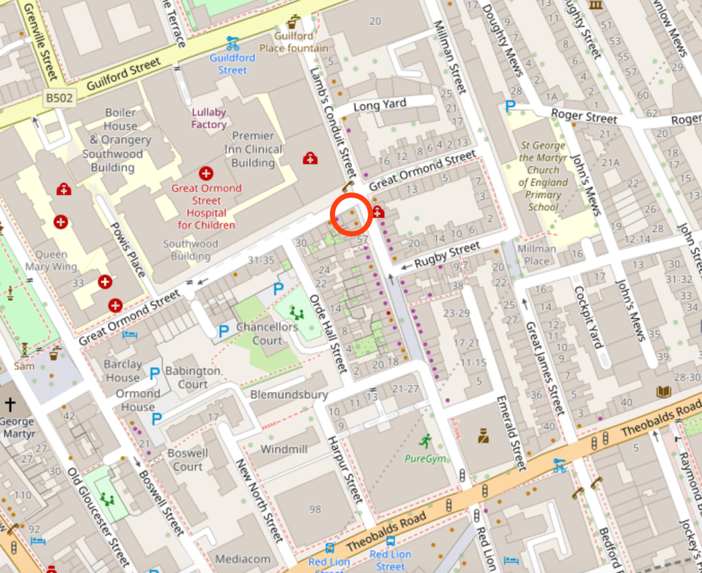
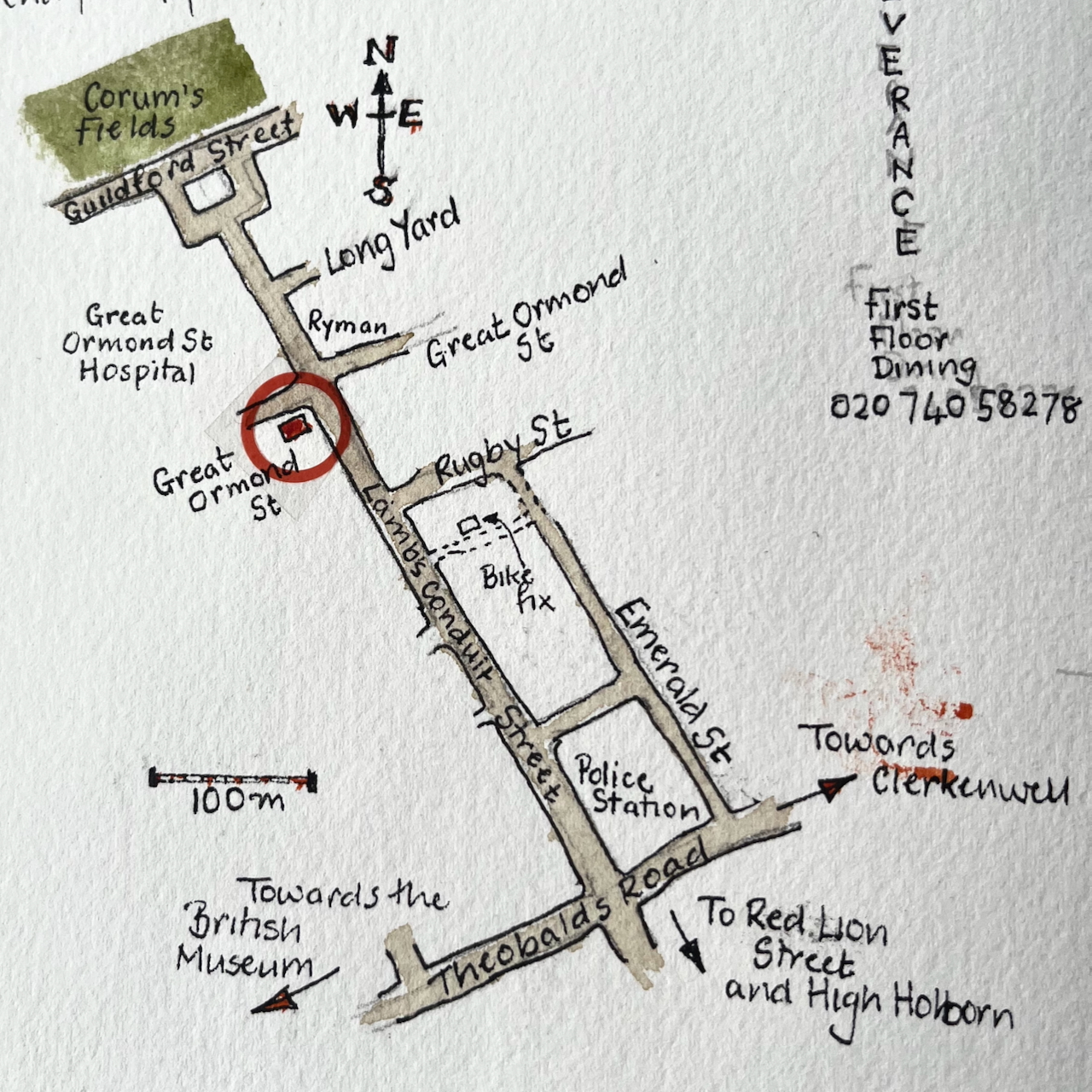
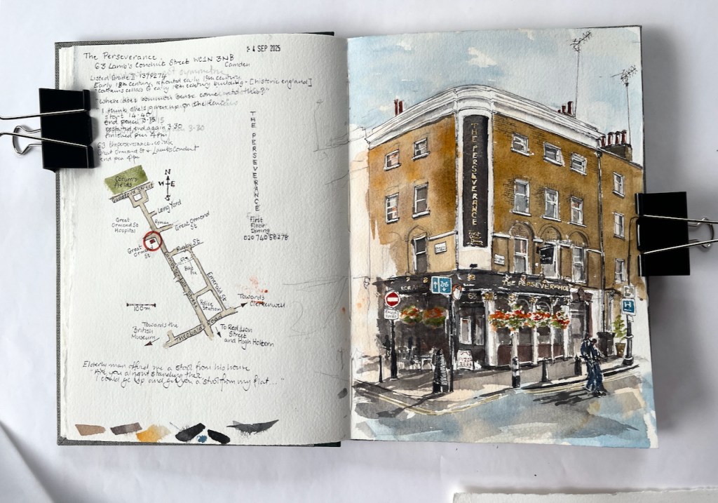
Here is The Perseverance, on the corner of Great Ormond Street and Lamb’s Conduit Street.
The Perseverance, 63 Lamb’s Conduit Street WC1N 3NB, sketched 4th September 2025 in Sketchbook 16
This pub was formerly The Sun, and had a magnificent painting on the corner. There are pictures and history on this detailed post from The London Inheritance. The many comments on the London Inheritance blog post describe happy memories of The Sun and its numerous Real Ale pumps.
The pub is listed Grade II reference 1379274. It was built in the early 18th century and the front was renewed in the 19th century. It was The Sun until the 1990s when the name was changed a few times, becoming the Perseverance around 2005/6.
I sketched it from the “Rymans” stationery shop which is on the opposite corner of the crossroads. People walked past me, deep in conversation, casting shadows in the afternoon sun. But one elderly man stopped, and looked up at me. His back was slightly bent. “Are you alright standing there?” he asked. I said I was, wondering what he meant. “Because,” he continued, “I could go up and get you a stool from my flat. It’s just up there.” He pointed heavenwards, to the windows above the shops. People are so kind. This man was so kind. It’s moments like this which make the sun rise on humanity. I was in fact quite tired, and would have liked to sit down, but my drawing was very nearly finished. I hesitated to send this helpful individual back up his stairs. So I declined his thoughtful offer, as politely as I knew how, and continued my drawing standing upright in the sun.
This drawing took 1 hour and 20 mins on location, plus another hour and a half at my desk later. The colours are:
Mars Yellow (brickwork)
Ultramarine Blue and Burnt Umber (mixed, for the greys and blacks)
Phthalo Blue Turquoise and Ultramarine Blue for the sky and the street, and the street signs
Transparent Pyrrol Orange for the “No Entry” sign and the flowers
Serpentine Genuine Green for the plants
A tiny bit of Permanent Yellow deep for the yellow line on the road, and other small touches
All whites are the paper.
Ink lines are De Atramentis Document black ink in an Extrafine Lamy Safari fountain pen
Paper is Arches Aquarelle 300gsm Cold pressed in a sketchbook made by the Wyvern Bindery in Hoxton.
Here are maps (click to enlarge):
(c) OpenstreetMap Contributors
Here is the sketchbook, size 7″ x 10″.
Click a button below to share this post online, email it, or print it:
My idea that day was to sketch some interesting corner pubs in Bloomsbury.
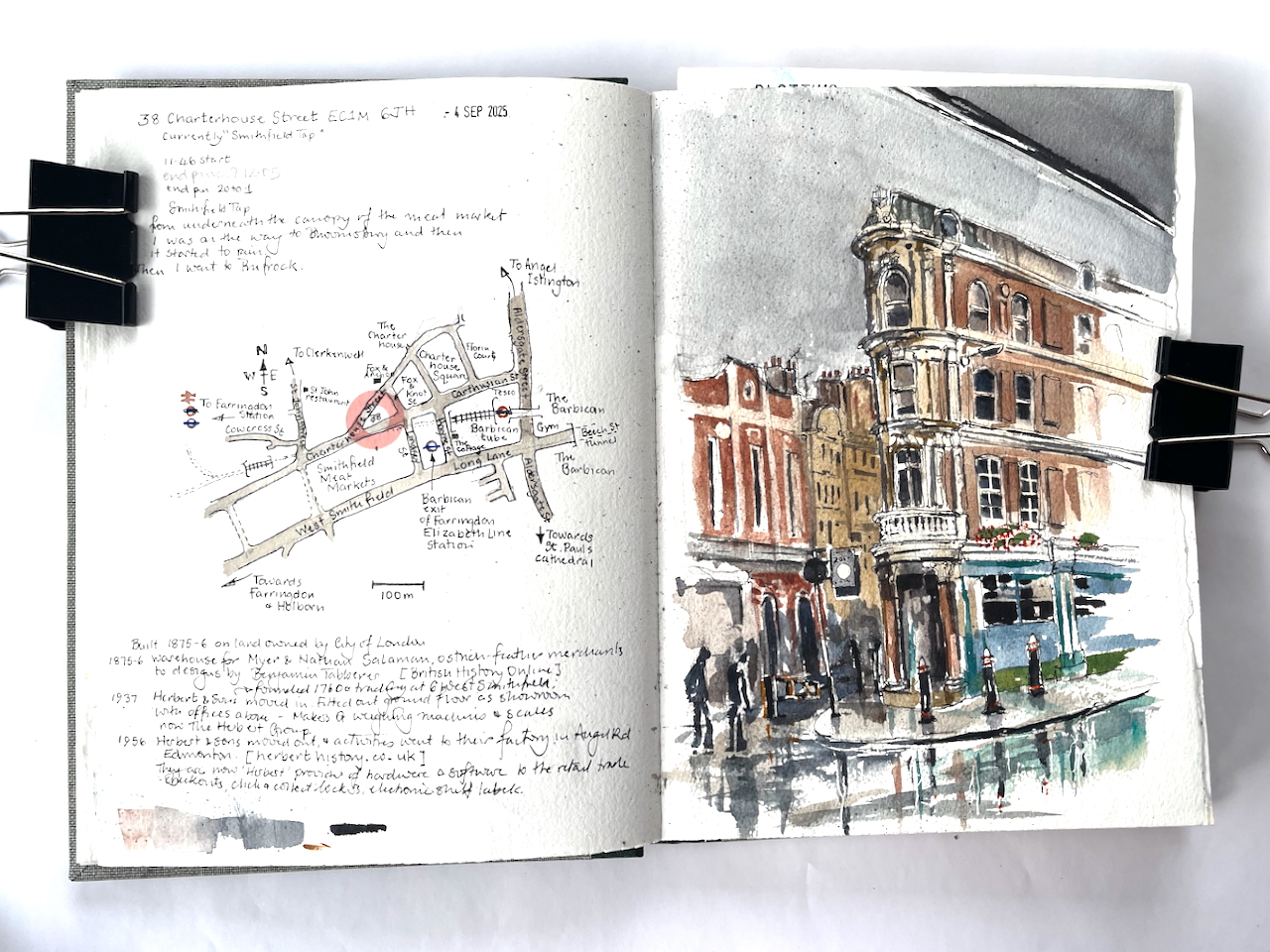
By the time I had emerged from my flat and was on the street, the bright autumn day had turned stormy. After a few paces, the rain started falling. Everyone dashed for cover. I sheltered in a doorway, together with another woman, two strangers in a refuge, grinning and rolling our eyes. “Well, it is September”. At a pause in the deluge, we both emerged and went our separate ways. I went doggedly towards the West, but no, the rain returned, seemingly even more torrential. I dashed from doorway to doorway, like a fugitive in a spy novel, finding cover where I could. Then I spotted the generous overhang of Smithfield Market and rushed underneath, the rain spattering on the glass above. There was no sign of the deluge ceasing, so I considered, as you do in these strange interim conditions: to go on? to go back? Or to stay where you are?
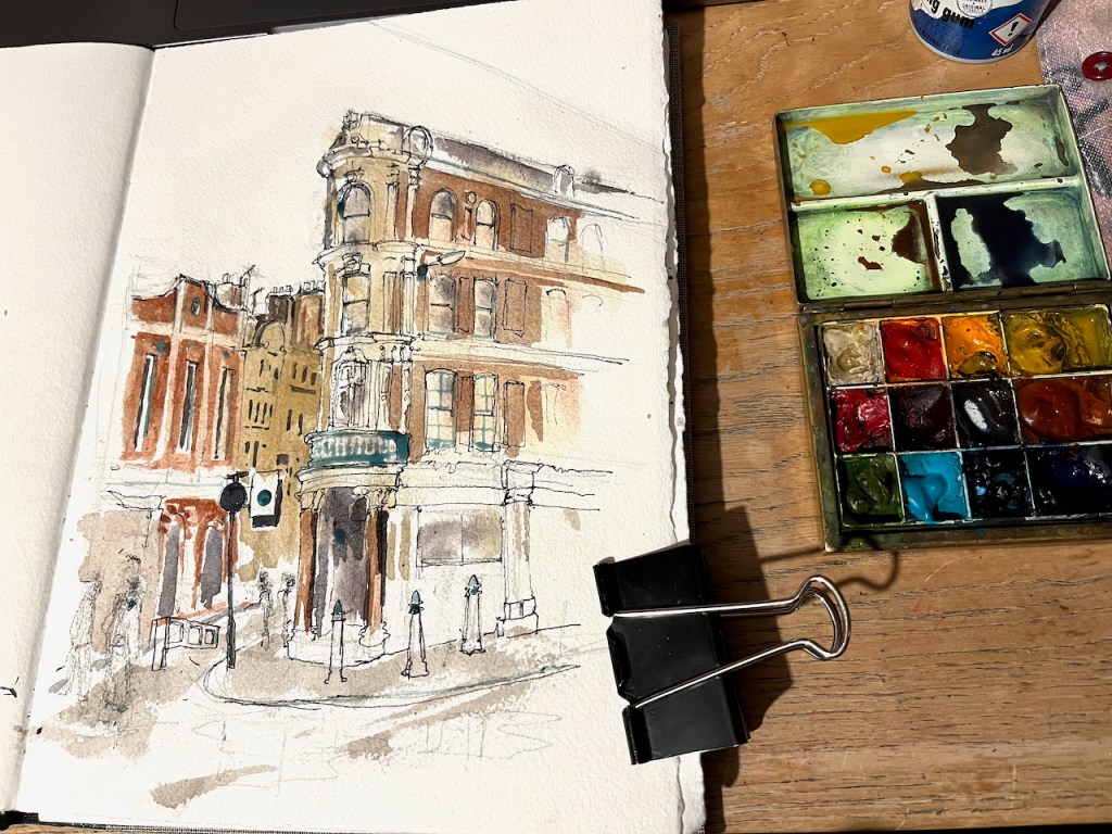
Why not do the drawing right here? Over the other side of the road is a building occupying an acute angle between roads. It wasn’t in my plan, but by this time I had abandoned my plan. So here is 38 Charterhouse Street, sketched from the shelter of the Smithfield Meat Market canopy.
38 Charterhouse Street, EC1M 6JH sketched 4th September 2025 in Sketchbook 16
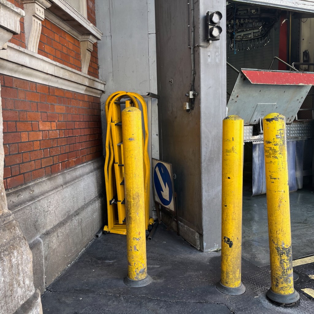
I sketched it in pen on location. Part way through the process, a group of workers started to clean the area behind me, using high-pressure water hoses. A fine mist appeared in the air, adding to the general dampness. I finished the drawing later that evening, in my warm dry room.
38 Charterhouse Street, photoDrawing in progress on locationDetail of finished drawingThis was where I was standing to sketch, this area was cleaned with high-pressure water hoses.
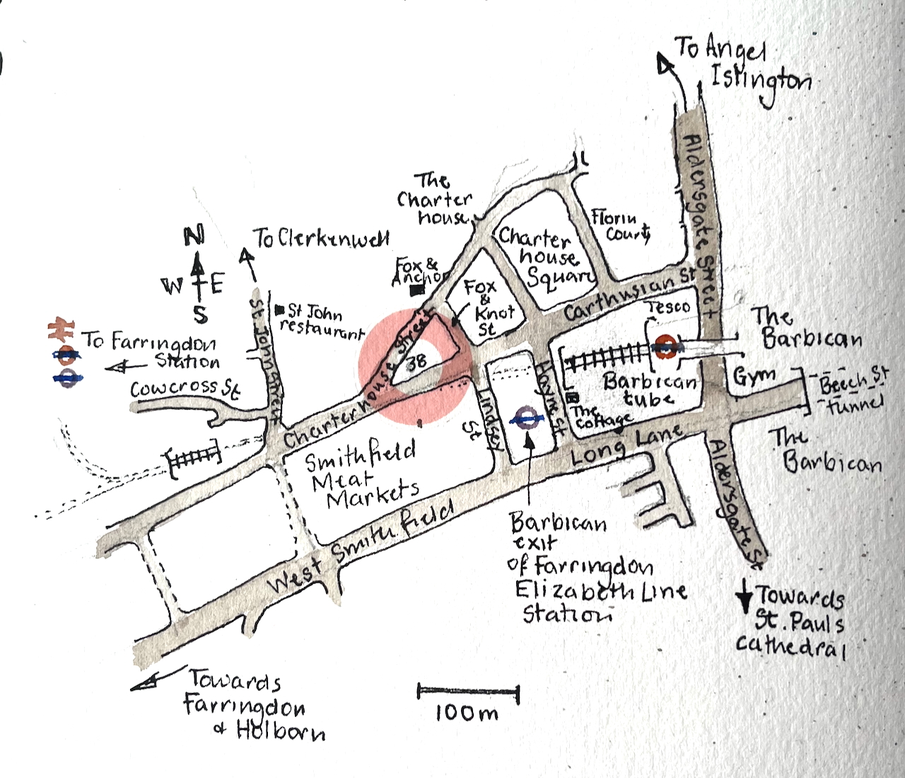
Here is a map.
As you see, number 38 stands on a little triangle of land, bounded by Charterhouse Street, Carthusian Street and the tiny alley called Fox and Knot Street.
British History Online offers some history for this triangular plot. In the 1860s the City of London redeveloped the Smithfield Meat Market. At the time it had been mostly an open-air market. The City turned it into the covered market it is today. The surrounding lanes and buildings were also affected, both by the redevelopment and the increased trade.
In 1869–70, with the new market building complete, it was resolved to take the new road along the north side of the market further east into the square itself, carried out in 1873–4. The road was called Charterhouse Street, apparently at the suggestion of the Charterhouse, Whereas in 1860 Charterhouse Lane enjoyed a mix of businesses, in 1876 half of the sixteen surviving houses were occupied by meat and poultry traders. The same trades dominated the new buildings put up, though there were also coffee rooms to rival the two remaining pubs and a large bank at the corner with St John Street. By the time of the Second World War most of the buildings west of the Fox and Anchor at No. 115 were purpose-built cold stores. Only with the decline of Smithfield Market did the grip of the meat trades loosen. Today restaurants and bars have largely supplanted them.
The Fox and Anchor pub and the former cold stores are on the left of my drawing. I’ve drawn the marvellous frontage of the Fox and Anchor here.
British History Online describes the block on the corner, number 38:
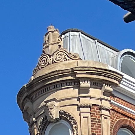
The City of London arms on the building today.
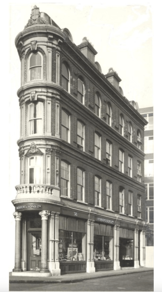
The remnant of ground at the angle between the old and new roads was laid out for a small block of buildings and allotted the numbers 38–42 (even) Charterhouse Street, behind which a tiny street, Fox and Knot Street, was cut through in 1871. The name was taken from Fox and Knot Yard, a court obliterated by the new market.
The small triangular block west of Fox and Knot Street […] just within the City boundary, belongs to the land acquired by the Corporation of London in the 1860s for the Smithfield Market development. Set out for building in 1871–2, it remained empty until 1875–6. At the apex a warehouse (No. 38), was then built for Myer and Nathan Salaman, ostrich-feather merchants, to designs by Benjamin Tabberer. […] It is four storeys high, of red brick with regular fenestration; all the ornamentation is concentrated on the narrow corner. For many years there were coffee-rooms here.
So, in 1875 it was an ostrich-feather warehouse, which must have been a great place to visit. The next mention of the building is on the website of Herbert, a present-day supplier of technology to retail businesses. They have a section of their website devoted to their long history. In the early twentieth century they were supplying weighing machines and balances from their offices in West Smithfield and a factory in Edmonton.
Herbert and Son moved out in 1956 and consolidated their operations into their Edmonton site. Since then, the building has been a coffee house, and, more recently, various bars. It is now the “Smithfield Tap”.
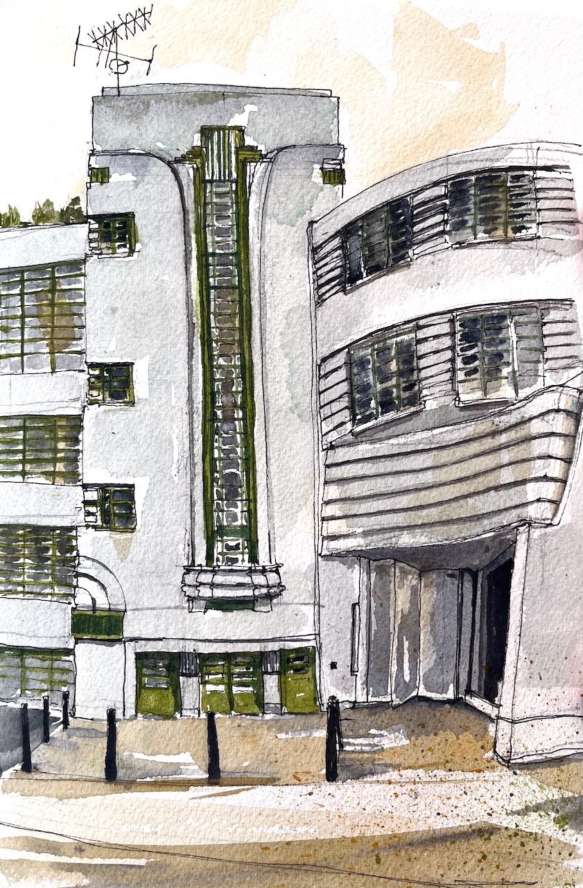
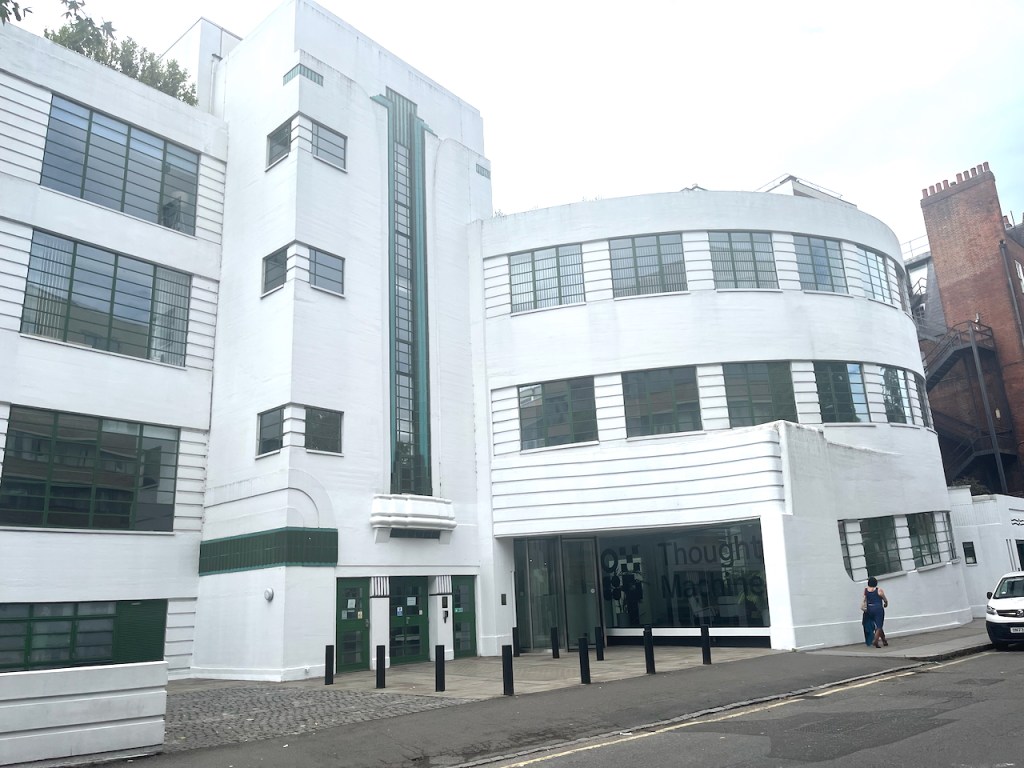
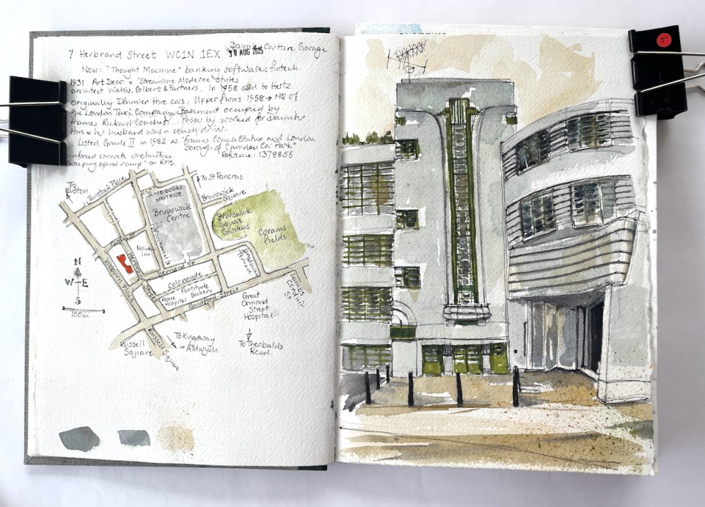
In a backstreet in Camden is a magnificent Art Deco building.
7 Herbrand Street WC1N 1EX, sketched 30 August 2025 in Sketchbook 16
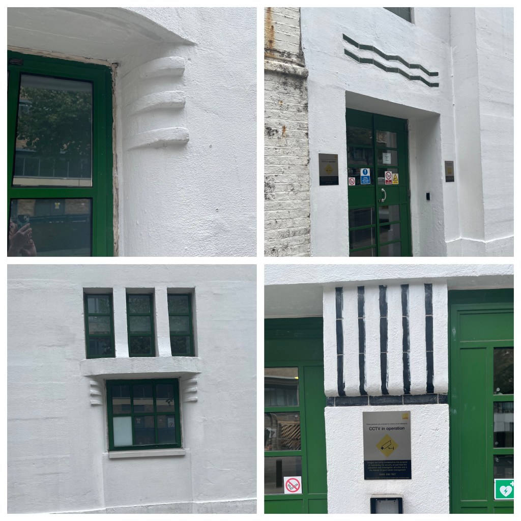
This was built of re-inforced concrete in 1931, to the designs of architects Wallis, Gilbert and Partners. The style is called “Streamline Moderne” and includes fun details.
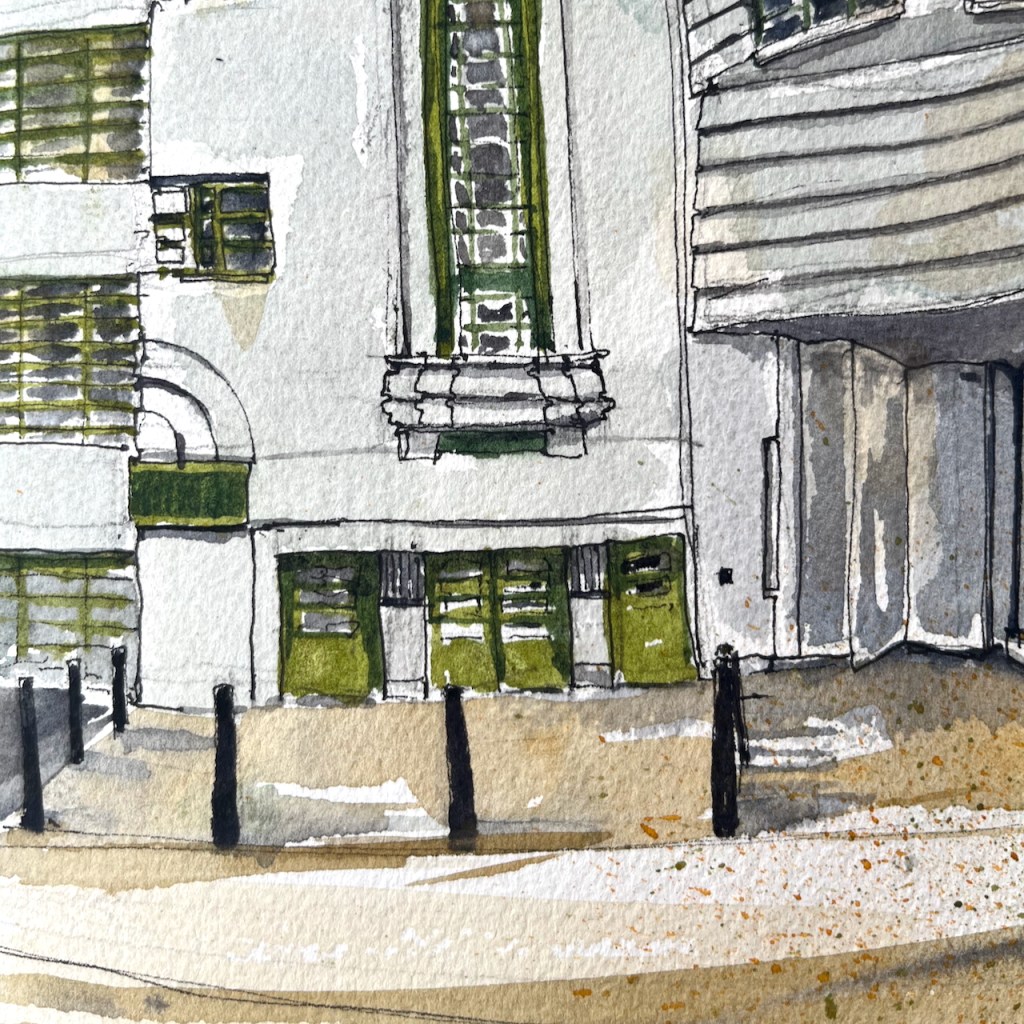
7 Herbrand Street, details
It was originally used as the headquarters of Daimler Hire Cars. It includes a spiral ramp, off to the right of my picture. This was where the cars entered and drove up to the garage.
General view of 7 Herbrand Street showing the former garage entrance (centre right). The spiral ramp was in the curved part of the building to the right.
As I was sketching, a passer-by approached me to tell me the history of the building. She worked for Daimler Hire, in the offices on the upper floors. Her husband was a driver, she told me. Later the building was used as the headquarters of the London Taxi Company, and by Hertz car rentals. The basement was occupied by Frames Rickard Coaches.
The building was listed Grade II in 1982, number 1378855. The listing calls it “Frames Coach Station and London Borough of Camden Car Park”. It is now occupied by a fintech company called “Thought Machine” who provide banking software. The spiral ramp has been removed.
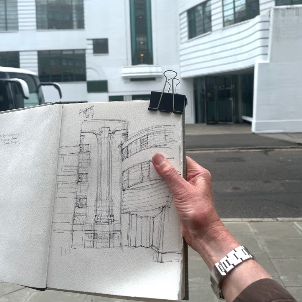
This building with its curves was tricky to draw and took me a long time. The person who had approached me to describe the history returned back up the street. She held out a hand containing fresh hazel nuts she had collected from the pavement. “I don’t think Camden Council realise they have planted hazelnut trees” she said.
Once the pen drawing was finished, I ate a sandwich from nearby Fortitude Bakery, and walked home to finish the drawing at my desk.
Sketchbook 16
Click a button below to share this post online, email it, or print it:
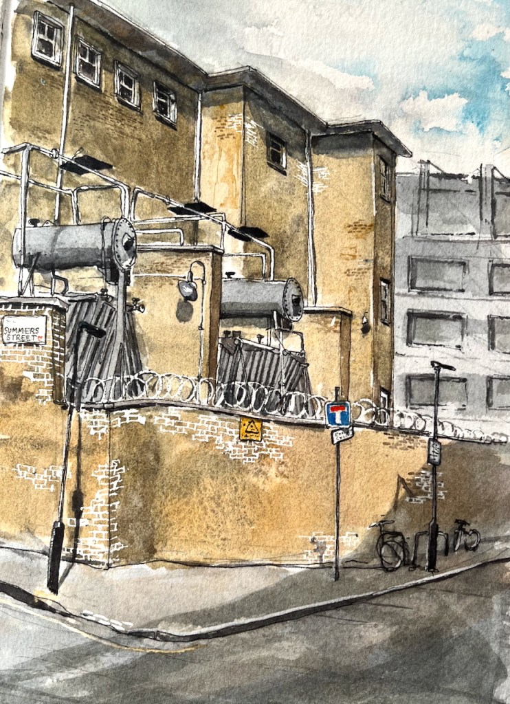
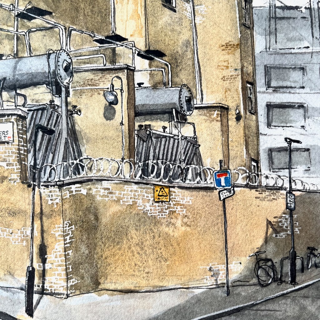
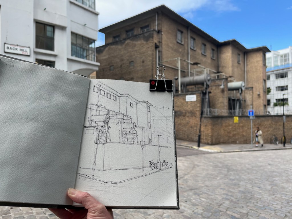
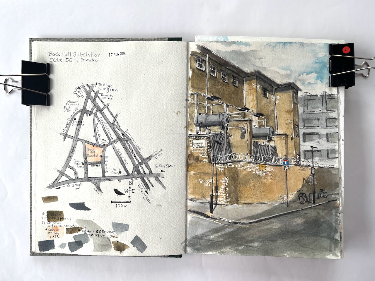
This imposing building presides over an entire block, in the back-streets of Camden. I’ve admired its austerity and unadorned walls, amongst the much more elaborate buildings around. This is an electricity substation, very functional. I’d noticed it while sketching The Coach, a nearby pub.
Back Hill substation, EC1R 5ET, sketched 27 August 2025 in Sketchbook 16
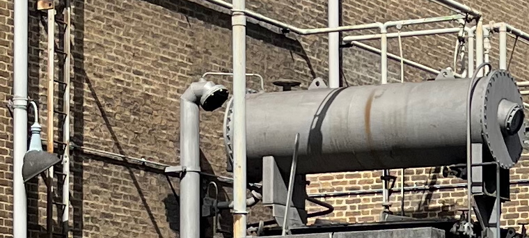
There were many more pipes and connectors than I could fit into the drawing. They all looked important. This is a serious building. The sign on the wall says “Danger of Death”. But the pipework has a certain lighthearted steampunk appeal. The arrangement has lamps, ladders and valves in odd places, and inexplicable vents, as though it might huff and exude puffs of steam. But when I saw it, the whole structure was silent and still.
“silent and still”
The building is from the 1950s.
This complex dates mostly from 1956–7, when the London Electricity Board extended an earlier yard established in the late 1920s by its predecessor, the London County Council’s County of London Electric Supply Co. The 1950s buildings, designed by the LEB’s Architect’s Section, are of reinforced-concrete and steel frame construction with elevations of buff-coloured brick and glass block. They match the original building in the southeastern corner of the site ….
‘West of Farringdon Road’, in Survey of London: Volume 47, Northern Clerkenwell and Pentonville, ed. Philip Temple (London, 2008), British History Online https://www.british-history.ac.uk/survey-london/vol47/pp22-51 [accessed 11 September 2025].
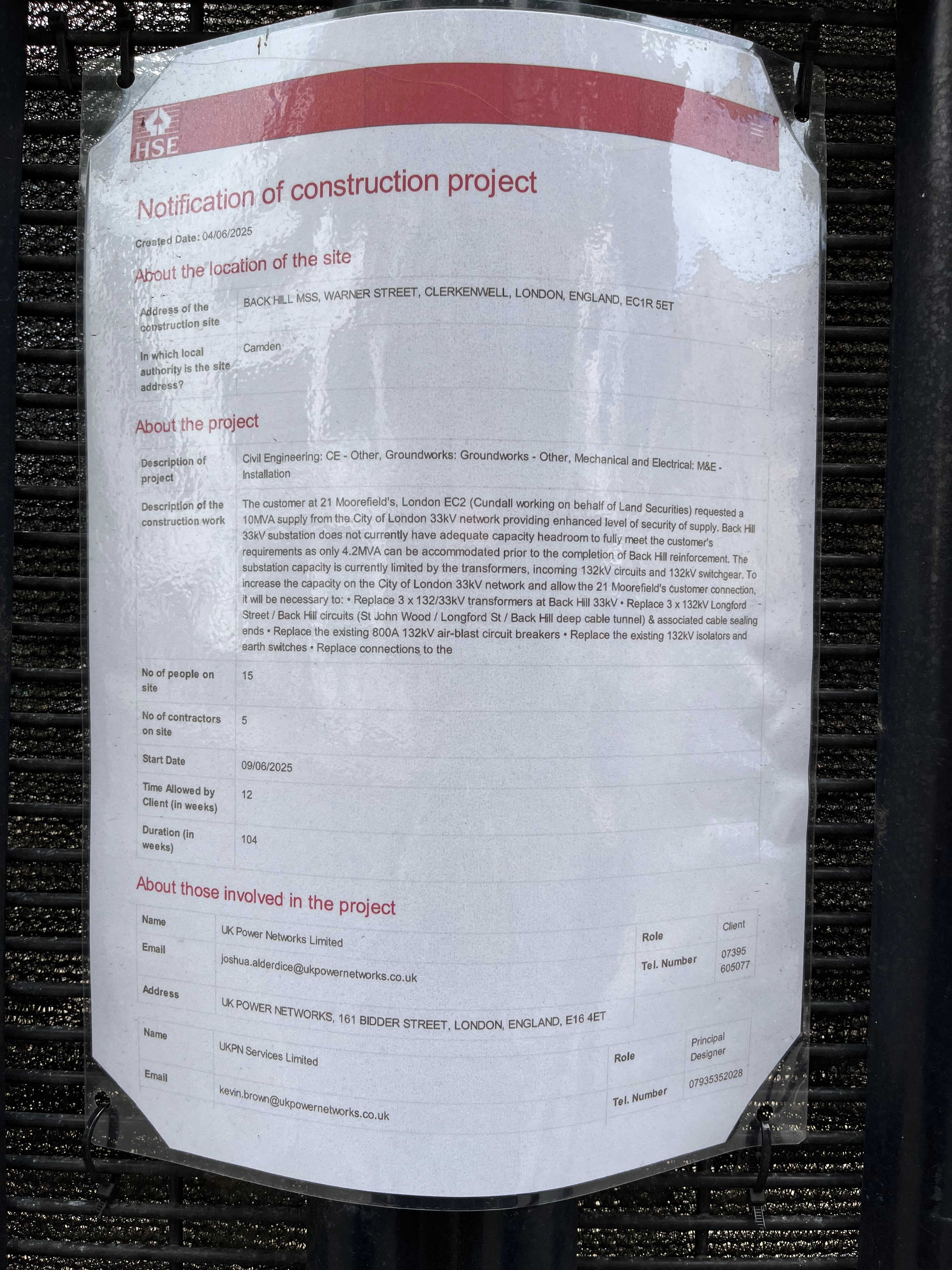
The planning notice on the gate: click to enlarge
It is very much in active use and currently being enhanced. Planning notices fastened to the main gates informed me that: “The customer at 21 Moorefield’s [sic], London EC2… requested a 10MVA supply from the City of London 33kV network providing enhanced level of security of supply.” They don’t want any fluctuation in the power supply, then, and no power cuts.
At the moment: “Back Hill 33KV substation does not currently have adequate capacity headroom to fully meet the customer’s requirements…” and “The substation capacity is currently limited by the transformers, incoming 132kV circuits and 132KV switchgear..”
So they have to replace the transformers, cabling and switchgear, to “allow the 21 Moorefield’s customer connection,” the notice says.
21 Moorfields is the building above Moorgate Elizabeth line station, just to the East of the Barbican.
21 Moorfields, from the Barbican Highwalk under Willoughby House.
“Electrical Contracting News” provides a more general description:
Almost 10,000 customers from Farringdon, Clerkenwell and key buildings in City of London are to benefit from a multi-million pound investment to upgrade the electricity network.
Work is currently underway to install the first of three new transformers – a device which steps down the power voltage so electricity can be safely delivered to local properties. The transformer, along with new switchgear equipment, will be installed at UK Power Networks’ substation to meet greater energy demand in the area. The £24 million project started in October 2021 and is due to finish in early 2026. As part of the scheme, the firm has consulted local councils and other interested parties to ensure that people experience as little disruption as possible while the work takes place. Euan MacRae, Project Manager at UK Power Networks, says: “This substation upgrade is part of our ongoing investment in the network to maintain safe and reliable power supplies and future-proof the network. The City of London is home to some of the capital’s most iconic buildings, so in collaboration with our alliance partner The Clancy Group this project is committed to carrying out a staged replacement of the major electricity assets at Back Hill Substation, some of which date back to 1956 and have been well maintained over the years. “We are excited to be installing innovative equipment which will allow the substation to provide double the previous level of power and will improve the resilience of power supplies across the network in London.”
I was pleased with my sketch of the substation, and I enjoyed trying to follow the lines of the pipes.
I find it fascinating to realise that there is enormous work going on to keep the electricity flowing, with very little fanfare. There are these silent buildings sitting amongst the offices and flats, doing their job.
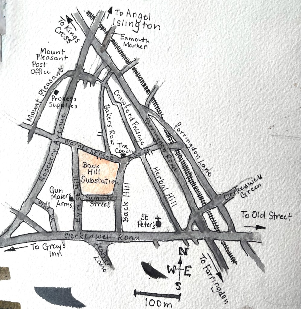
Here is a sketch map to show where the substation is:
The location of Back Hill Substation.Back Hill substation, page spread, Sketchbook 16
I’ve sketched the nearby pubs, the Gunmaker’s Arms here, and The Coach here.
Kenwood House is a mansion at the top of Hampstead Heath, to the North of London. It is managed by English Heritage. At the moment there is an exhibition “Heiress: Sargent’s American Portraits”. Fantastic oil paintings, each woman with a history, echoes of the time of Henry James. Even more than the oil paintings, I enjoyed the charcoal portraits. See the character of the sitter! See the skill of the artist! Recommended: it’s on until 5th October 2025.
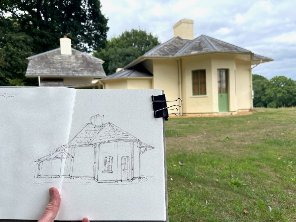
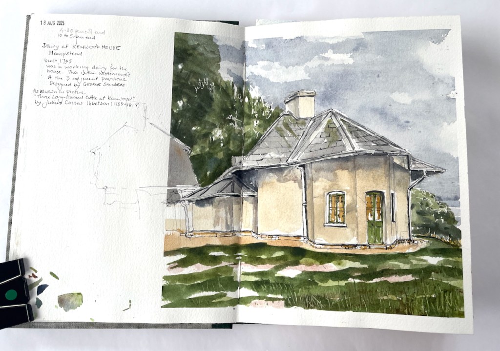
After that, we walked out into the late afternoon sun. Kenwood is a large building. It was too much to take on the house as a sketch project at that time of day. So I sketched a small building I’d spotted on the way in. This is “Kenwood Dairy”. I sketched just a part of it.
Kenwood Dairy, south pavilion, sketched 18 August 2025 in Sketchbook 16, approx size 9″ x 9″.
You can see the whole dairy in this oil painting of 1797 by Julius Caesar Ibbetson:1
The pavilion I sketched is the one on the left. There were sadly no cattle, long-horned or otherwise, for me to put in my sketch.
The dairy was built in 1795, just a two years before Ibbotson’s oil painting. It was a working dairy, built to the designs of George Saunders, for Louisa, the wife of David Murray, 2nd Earl of Mansfield. It was fashionable for 18th century upper-class ladies to run dairies.
a dairymaid.. lived in the cottage and produced the fresh butter, cream, puddings and ice-cream enjoyed by the family and their guests.
English Heritage noticeboard near the dairy
These buildings are now used as a base for volunteers at Kenwood and Hampstead Heath.
Here is work in progress on the drawing:
It was quite tricky to follow the line of that roof. I managed to get the ink lines done, then it was time to go home. I added the colour later at my desk.
Kenwood dairy, finished drawing in Sketchbook 16
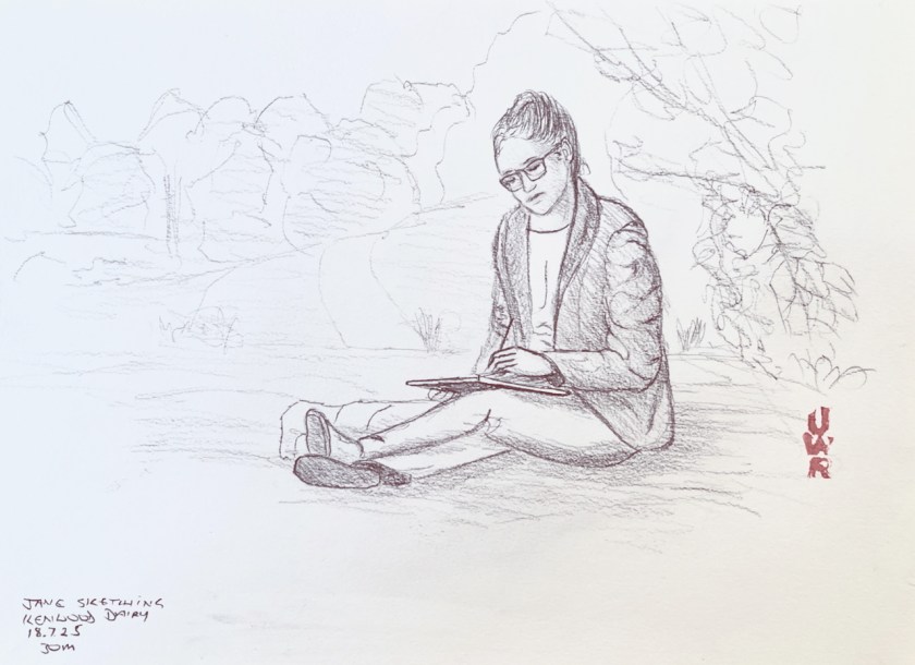
While I was drawing the dairy, John was drawing me, from a nearby bench.
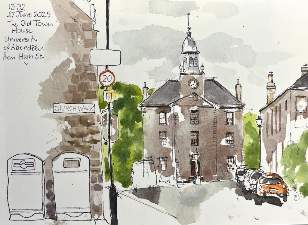
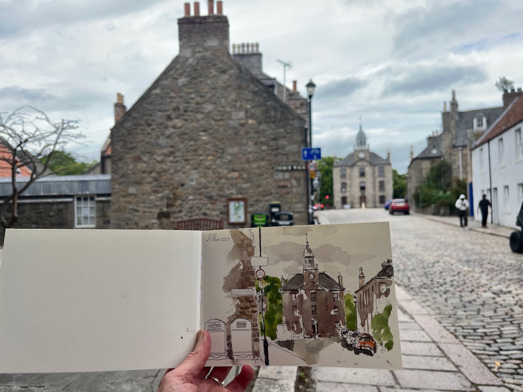
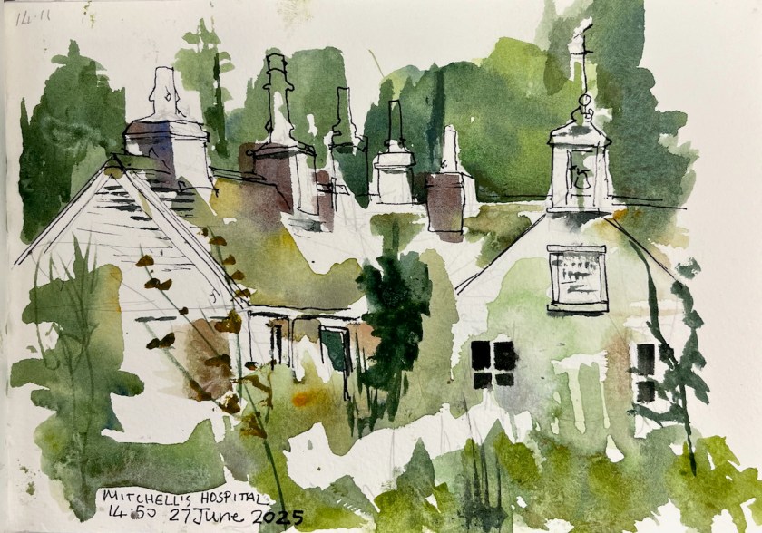
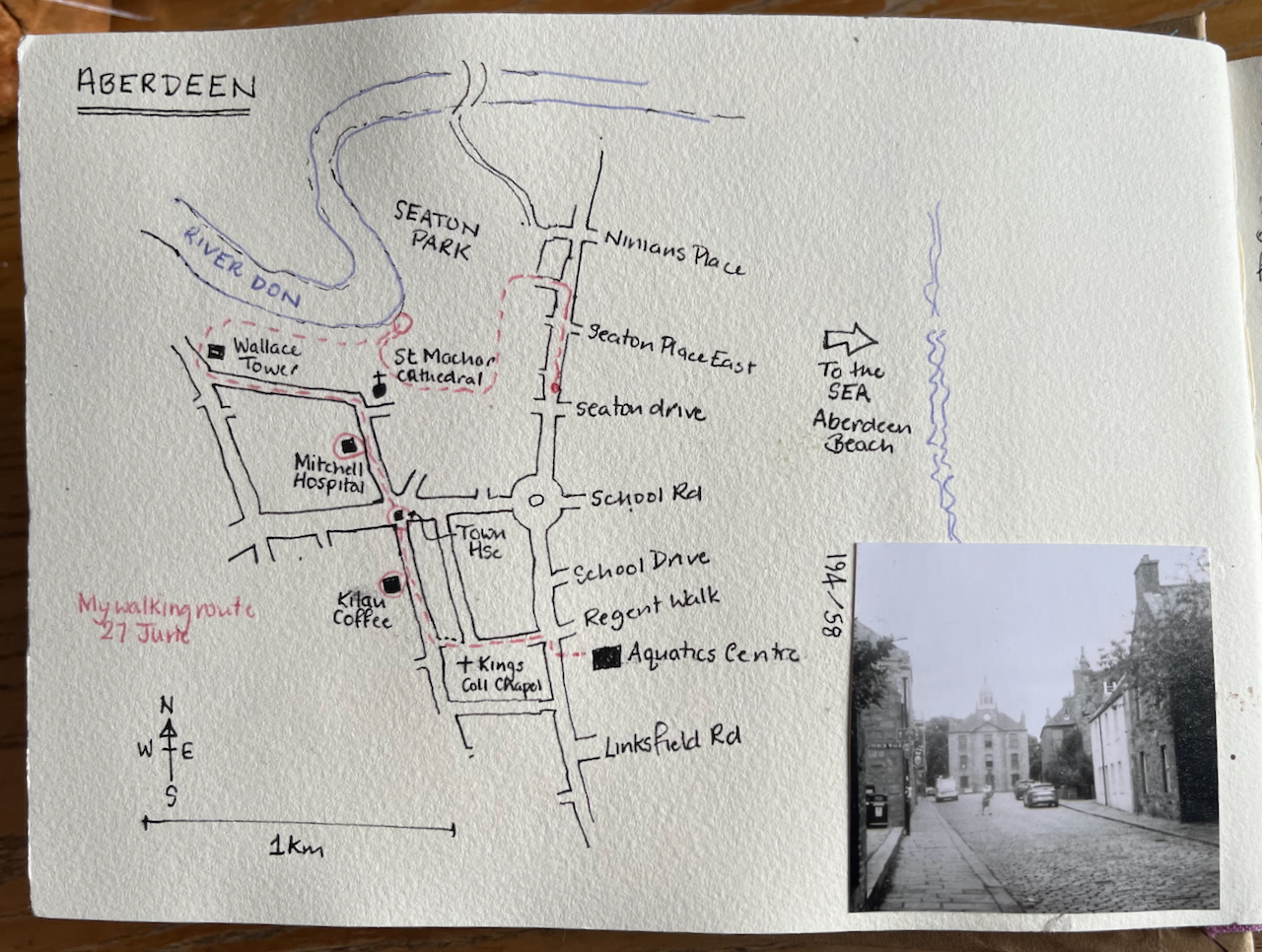
I had been travelling a long time. Reaching Old Aberdeen I sat on a granite kerbstone and sketched The Old Town House. Behind me was a friendly bookshop, where I had bought a map.
The Old Town House, University of Aberdeen, in Shetland 2025 sketchbook, size A5.
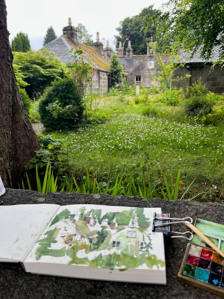
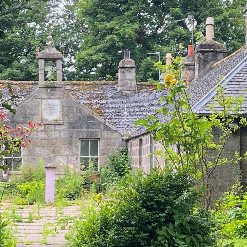
Having sketched, I walked into the picture I had drawn, and towards the trees on the left of the Town House. There I discovered a building being taken over by plants.
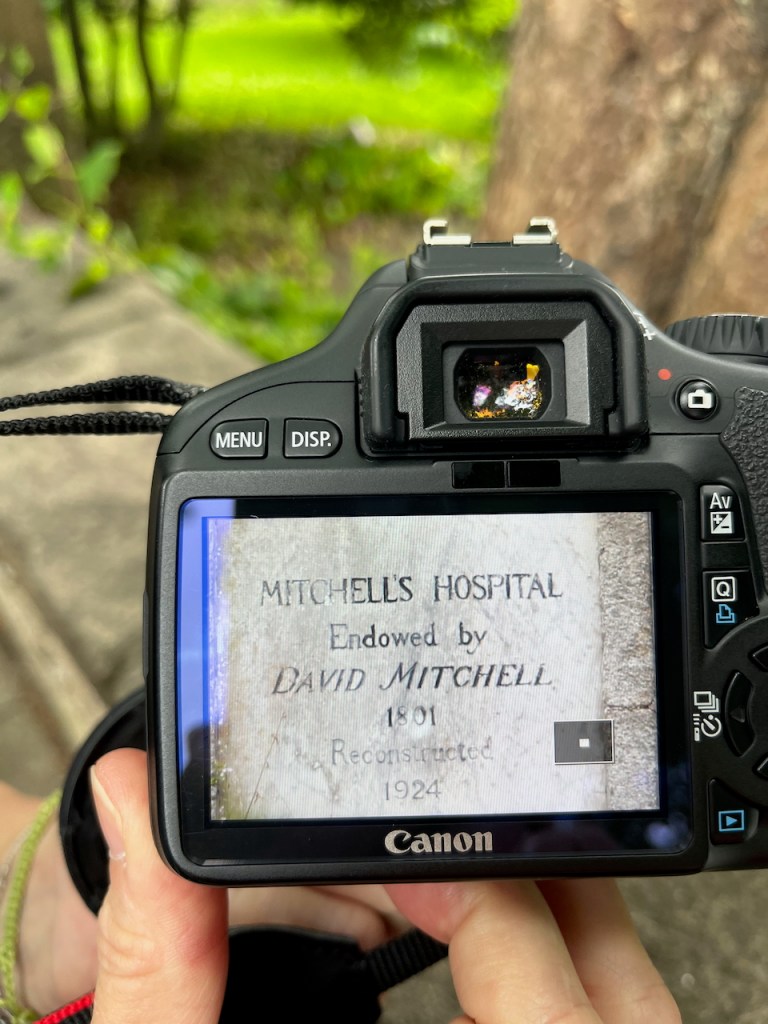
There was a plaque on the building, with writing on. You can see it in the background of the photo above. I couldn’t read the plaque at this distance, and neither could my phone.
Some tourists came by, laden with backpacks and cameras. They paused, curious to see what I was drawing. Since their eyes were younger than mine, I asked if they could read the plaque. They couldn’t, and neither could their phones. My next idea was that they could try using the telephoto lens on one of those formidable-looking cameras. With good grace they shrugged off a hefty block of technology, and removed its canvas housing. It had a fine lens.
“Mitchell’s Hospital, endowed by David Mitchell 1801. Reconstructed 1924.”
So now we know.
Mitchell’s Hospital, The Chanonry, Old Aberdeen. Sketch in “Shetland 2025” sketchbook, A5
David Mitchell founded the hospital as an almshouse “from a regard for the inhabitants of the city of Old Aberdeen and its ancient college and a desire in these severe times to provide lodging, maintenance and clothing for a few aged relicks and maiden daughters of decayed gentlemen merchants or trade burgesses of the said city..” [Wikipedia entry quoting the deed of mortification of the Hospital]. It was used as such, housing elderly ladies, up to to around 2016 when the final elderly resident, Iona Mathieson-Ross, had to move out.
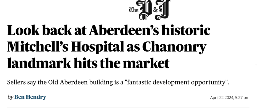
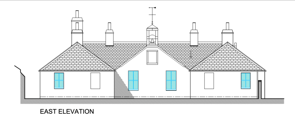
A later article says it has been sold, and that the new owners are refurbishing the building as small residential units to be let, possibly as short-term holiday lets. The planning application on Aberdeen Council’s website shows a building looking identical to the existing one, cleaned up and repaired.
From the planning application 241449/LBC Proposed elevations, North and East
It sounds like a dream come true for this neglected building:
“PROPOSED WORKS Roof: Allow for removal of all moss and vegetation Allow for replacement of missing slates in size, thickness and colour to match existing. Check ridge tiling and re-bed any loose tiles. Chimney stacks pointing to be checked and where missing to be repointed…
…Chimney cans to be reset…
Granite Masonry: Pointing to be checked and where missing to be repointed…
Windows: Existing sash & case windows to be checked & where wet rot is evident timber sections to be replaced with same profile in Redwood. Windows to be refurbished to ensure they are fully operational and fitted with draught stripping internally….
External Doors: Existing external doors to be replaced with external quality Redwood 4 panel doors with double glazed obscure glass in upper 2 panels fully weather stripped primed and painted…
The planning application was approved on the 3rd July 2025, a few days after I was standing there doing my sketch. Perhaps when I next visit Aberdeen the improvement work will be in progress. Maybe, if it becomes holiday lets, I can even stay there.
I’m glad it’s being refurbished, but I shall treasure the view of this graceful building gradually being assimilated into the plant world.
Here is a map showing my walk and Mitchell’s Hospital.
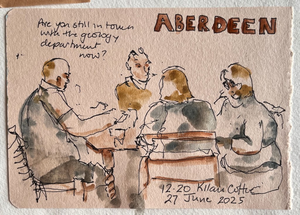
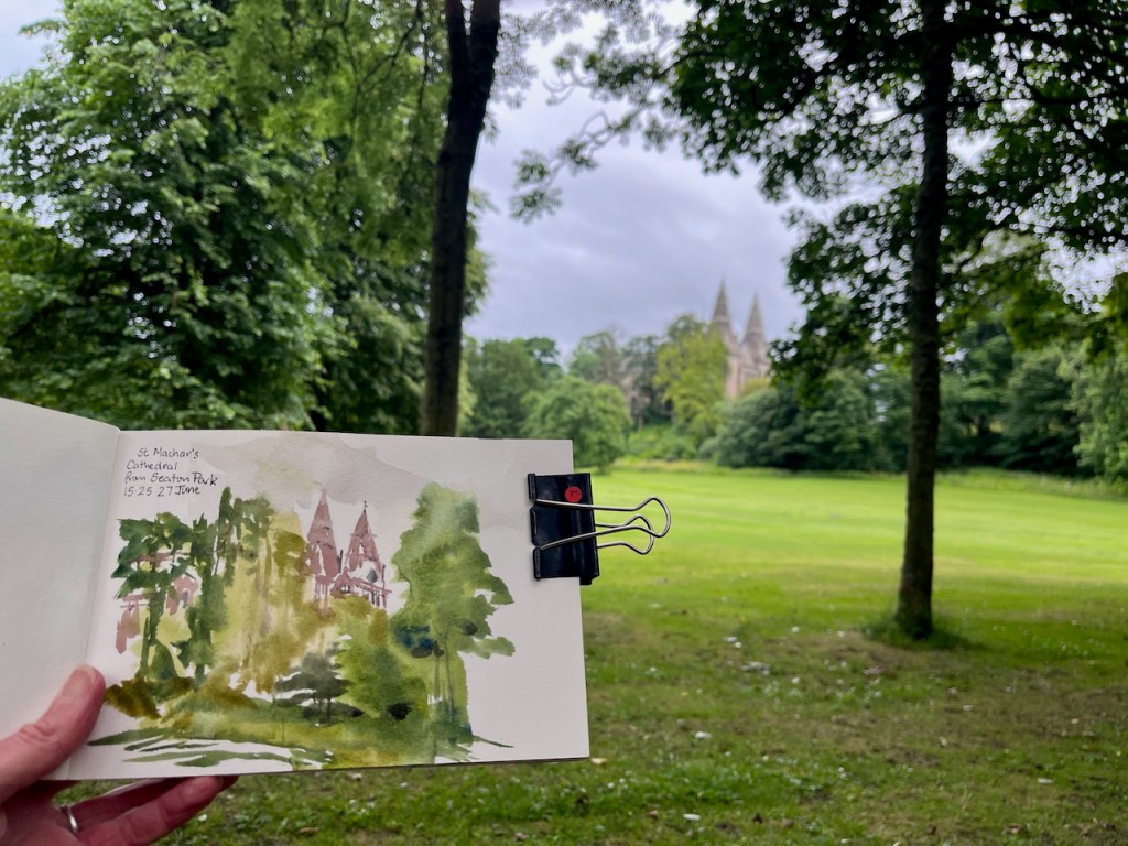
I had coffee in Kilau Coffee – recommended!Sketching in Seaton Park, before the rain. St Machar’s Cathedral.
Click a button below to share this post online, email it, or print it:
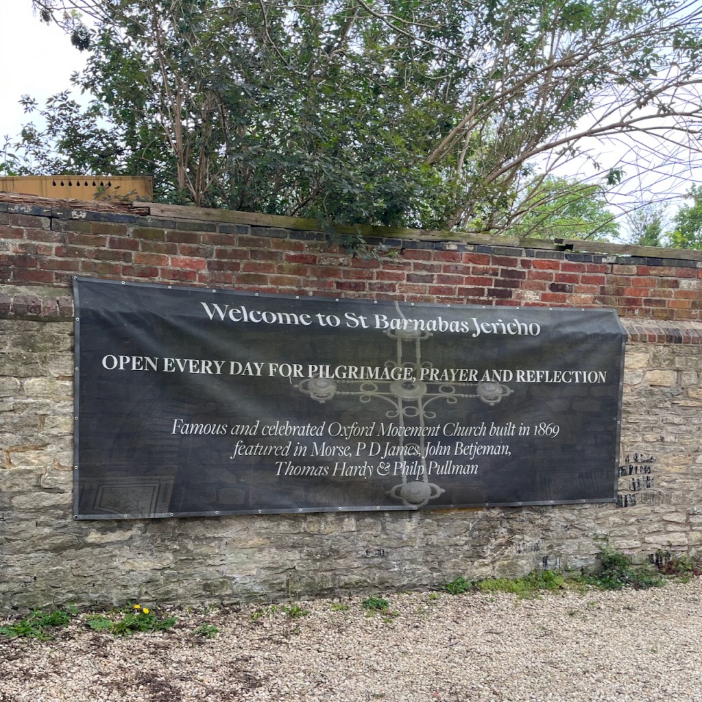
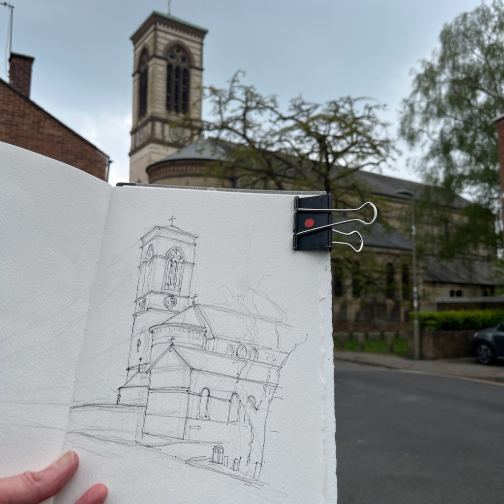
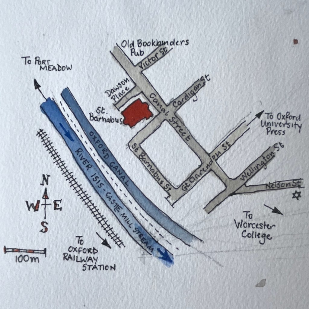
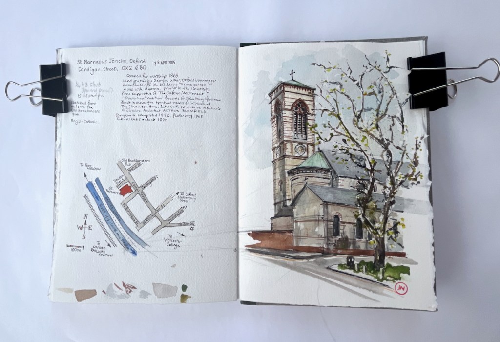
Walking through Jericho on my way to the station, I glimpsed this church tower, and heard its bells. I wove through the small streets until I found it.
St Barnabus Jericho, OX2 6BG, sketched 26 April 2025 in Sketchbook 15.
This is St Barnabus Jericho. Its website says that it is also known as “Oxford Basilica”. It was built as the daughter church of St Paul’s, which is the Grecian-style building on Walton Street, now no longer a church1.
St Paul’s is not far away, just the other side of The Oxford University Press. It was opened in 1836, and became part of the “Oxford Movement”. The Oxford Movement was campaign within the Church of England, led by influential clergymen and theologians in the 1830s. They challenged the contemporary way of thinking in the Church, saying that services were too plain, and that much of value from the Catholic tradition had been left behind. They sought to re-instate some of the theology, pageantry and ritual from the Catholic tradition, and they put it into their services. They also had a social calling, drawn to help working people and the disadvantaged.2
As you can imagine, this was contentious: popular with some people, and regarded as suspicious and un-English by others. In the 1830s, the movement flourished in this part of Oxford. The services at St Paul’s became so crowded that another church was needed. In addition, Oxford University Press moved into its huge site on Walton Street in 1830, which brought many workers to the area. So an additional church was created, and this was St Barnabus.
“The land for St Barnabas was given by George Ward who was an Oxford ironmonger, and the benefactor for the Church building was the generous Thomas Combe, Printer to the University, along his wife Martha.” [https://www.sbarnabas.org.uk/history]
St Barnabus opened for worship in 1869, and is flourishing to this day. Inside it is awe-inspiring and uplifting, with its highly decorated walls and vast size.
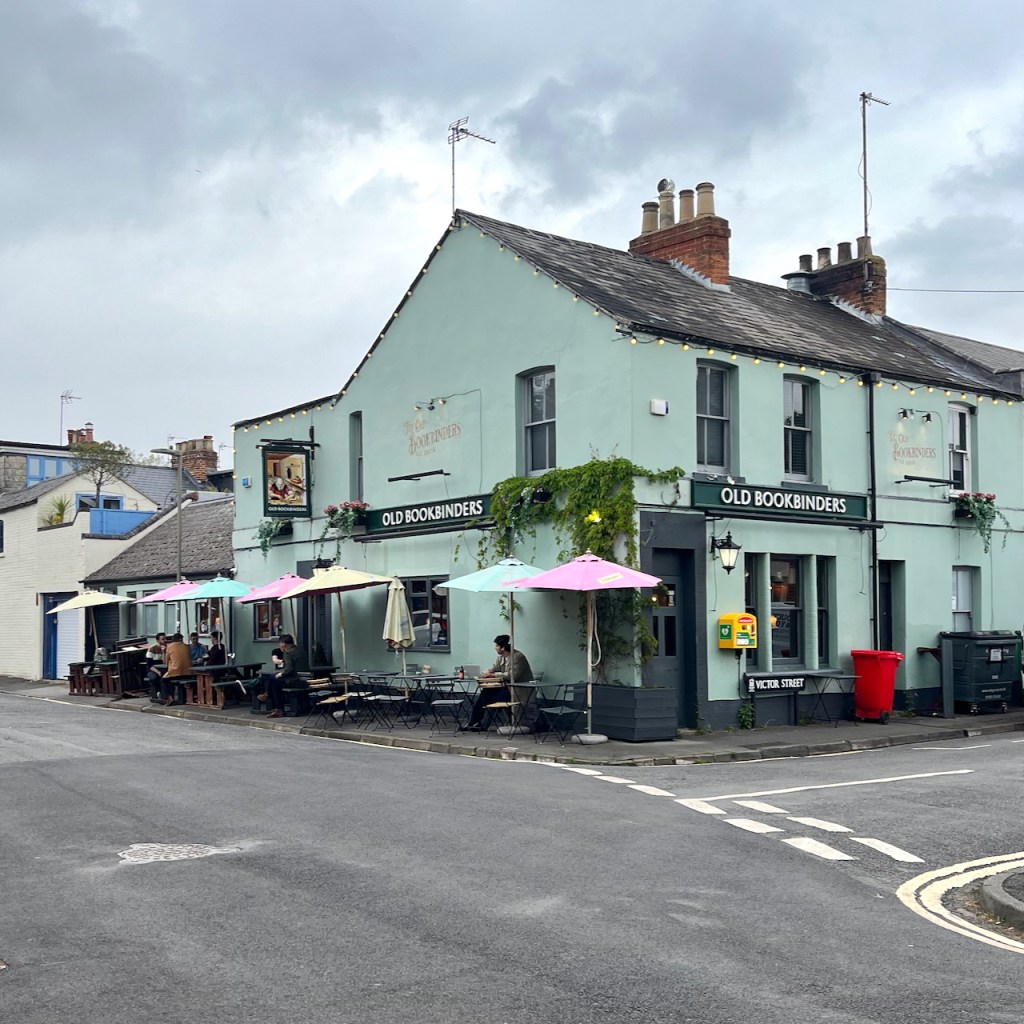
I sketched St Barnabus from outside “The Old Bookbinders” pub, delighted and frustrated in equal measure by the extraordinary detail in that tower. And I was looking at its clock, which informed me of the passing minutes until my train.
I finished the pen-and-ink drawing. Then I walked on, past Worcester College, to the railway station.
Sketchbook spread, St Barnabus Jericho. Sketchbook 15.
Footnotes
St Paul’s: the impressive Grecian temple building on Walton St is no longer a church, but the “St Paul’s” name lives on. I’ve done an earlier sketch which shows St Paul’s Nursery, still very much in operation and part of Somerville College. ↩︎
Oxford Movement: This is my non-specialist summary of a significant and complex theological and social movement. For a proper description see, for example the Wikipedia Article, or this glossary article.↩︎
Click a button below to share this post online, email it, or print it:


_-_Three_Long-Horned_Cattle_at_Kenwood_-_88029298_-_Kenwood_House.jpg)