The Perseverance, formerly The Sun, Lambs Conduit Street WC1

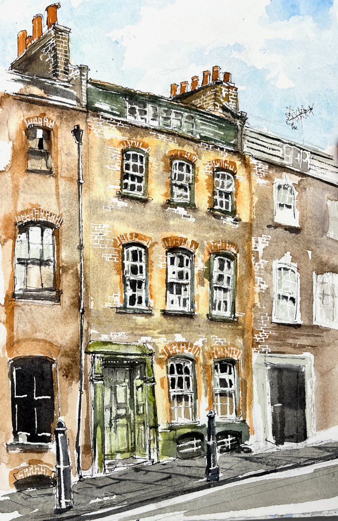
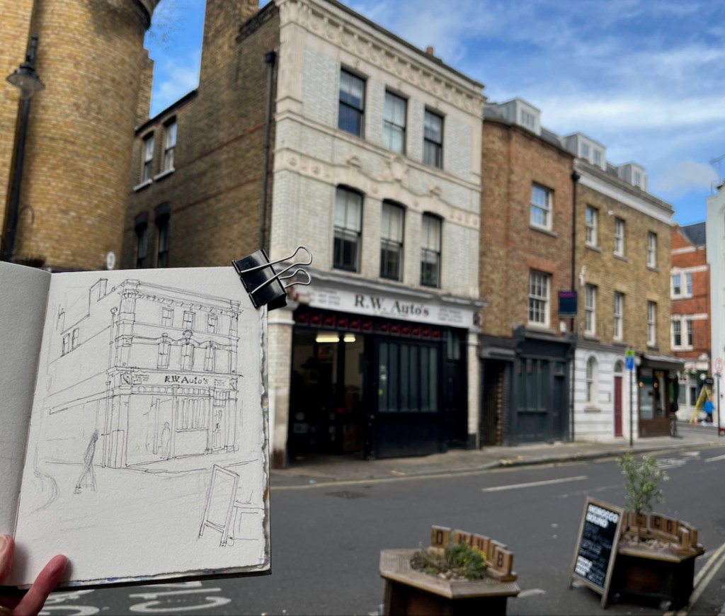
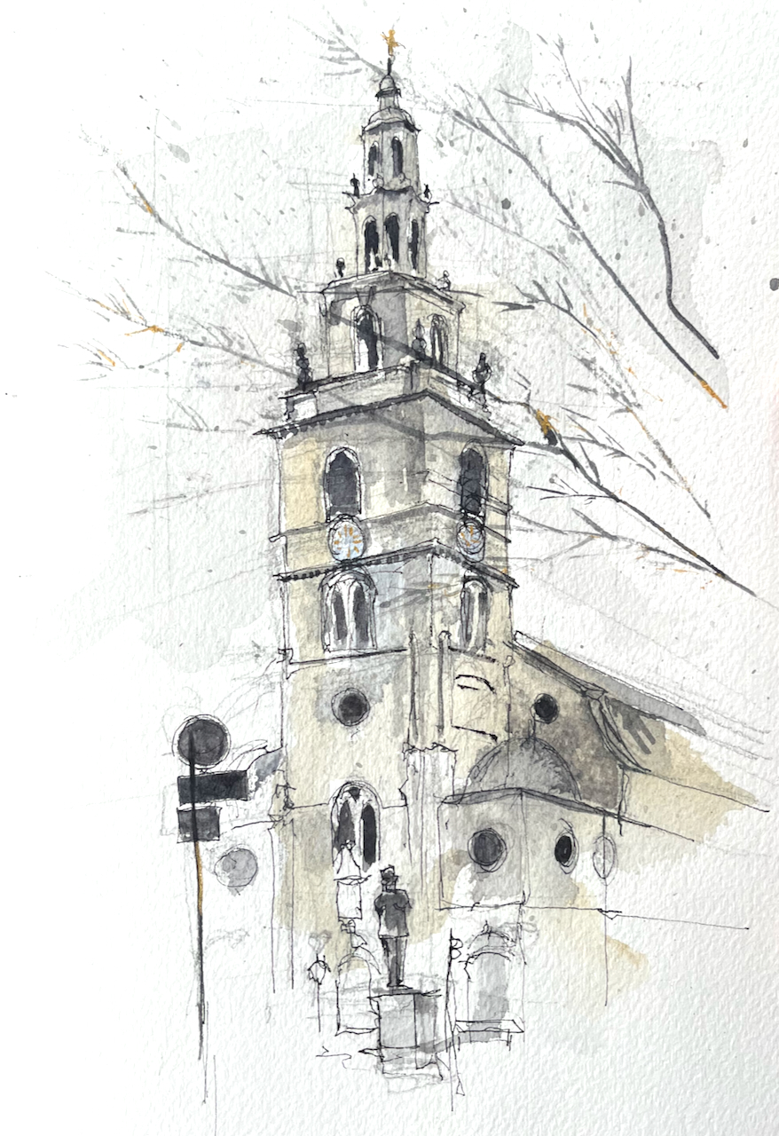
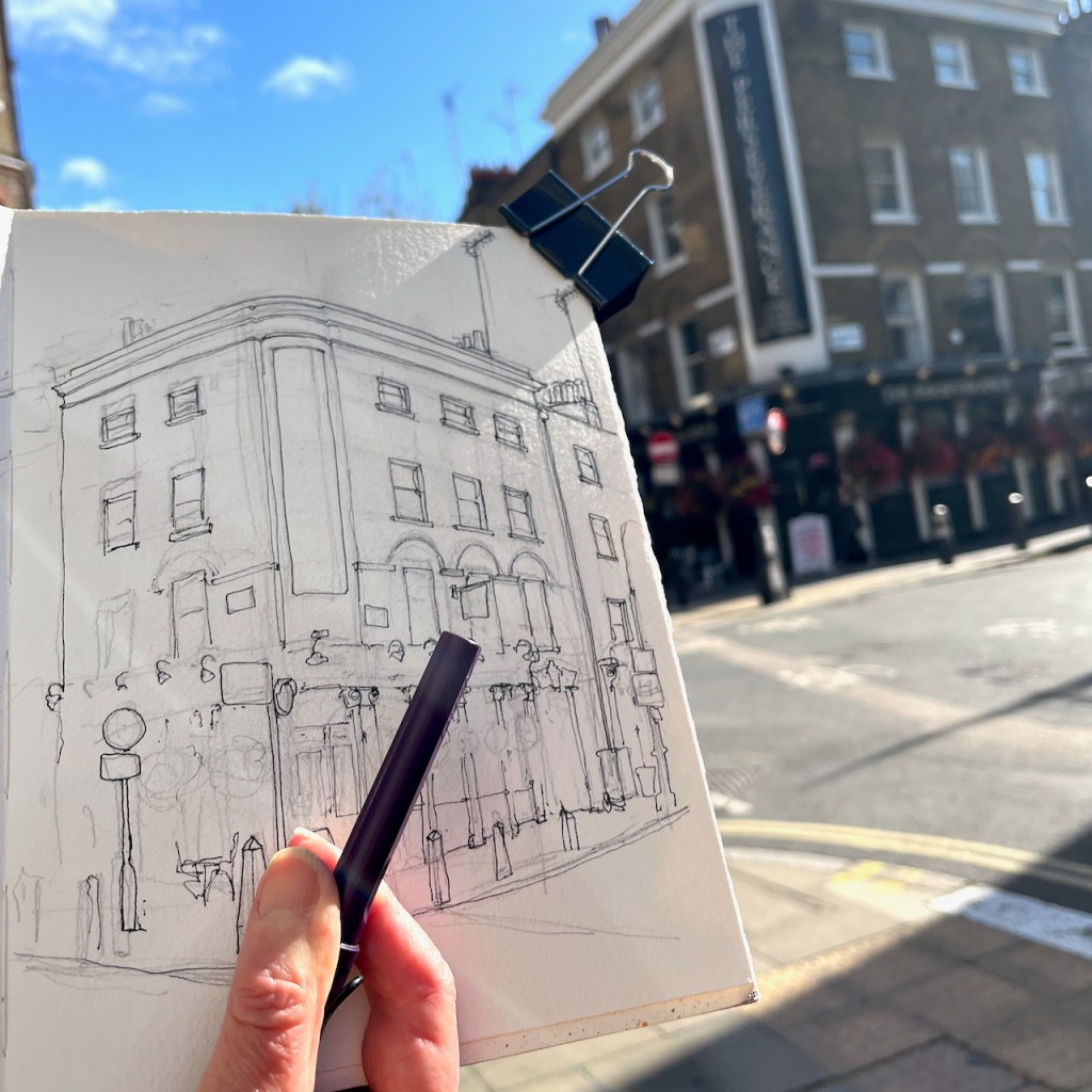
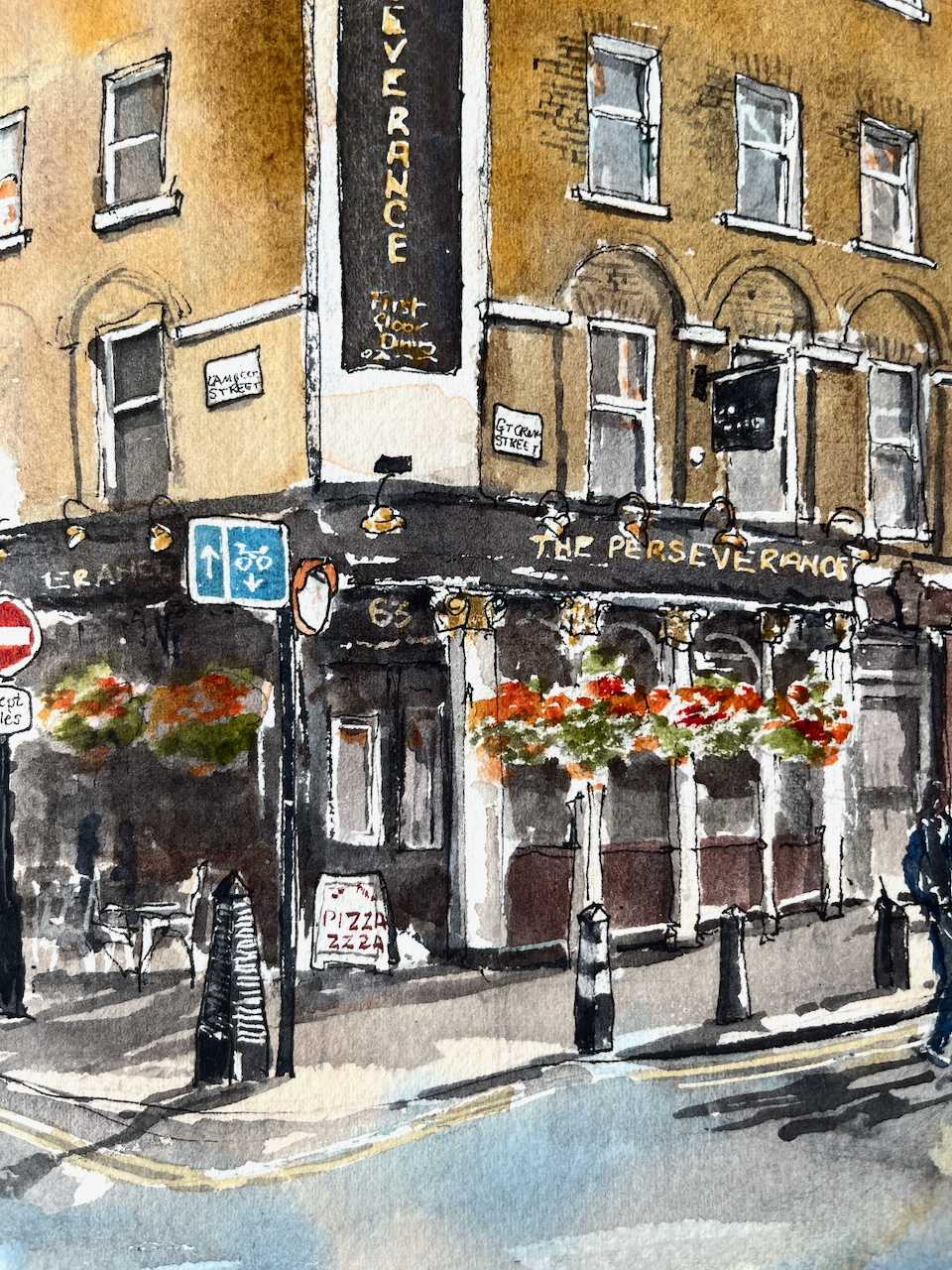
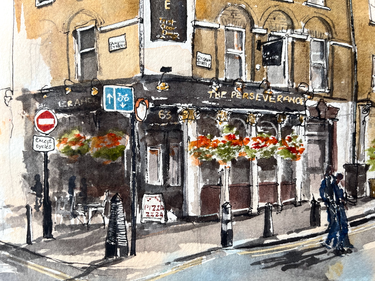
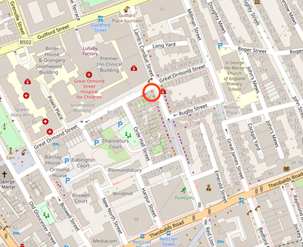
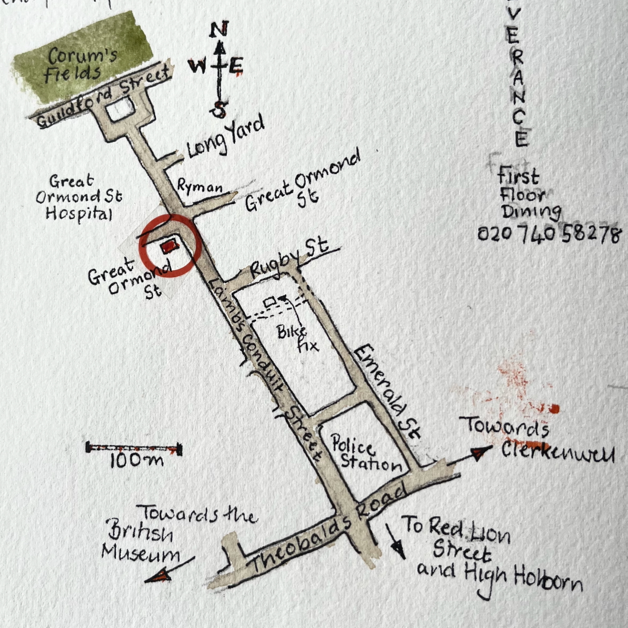
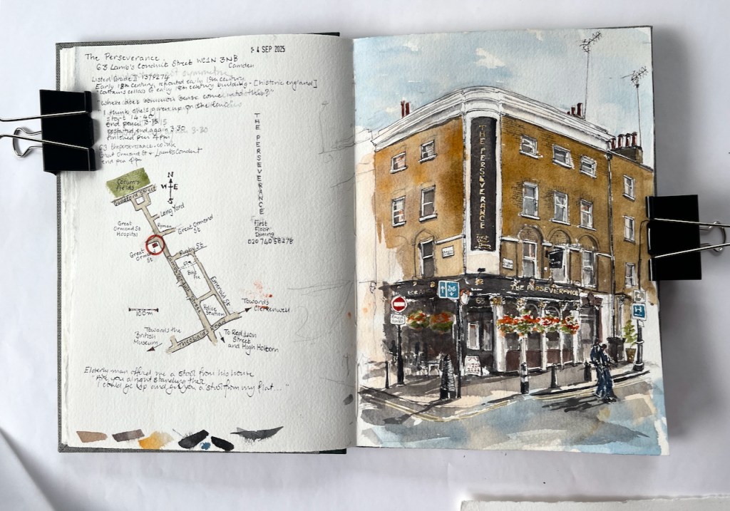
Here is The Perseverance, on the corner of Great Ormond Street and Lamb’s Conduit Street.

The Perseverance, 63 Lamb’s Conduit Street WC1N 3NB, sketched 4th September 2025 in Sketchbook 16

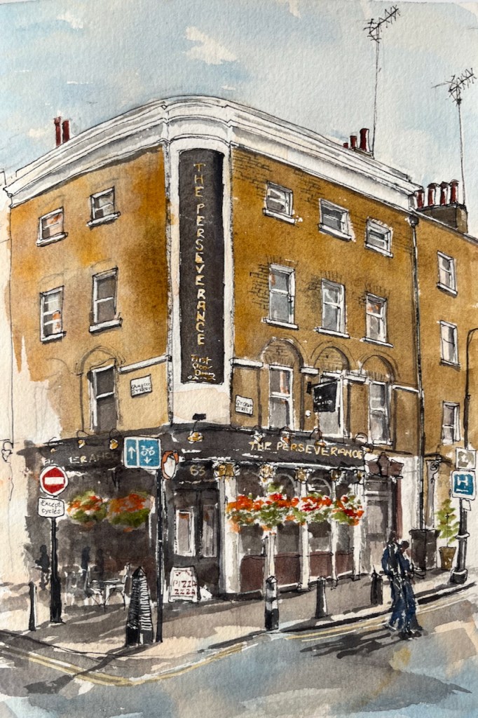
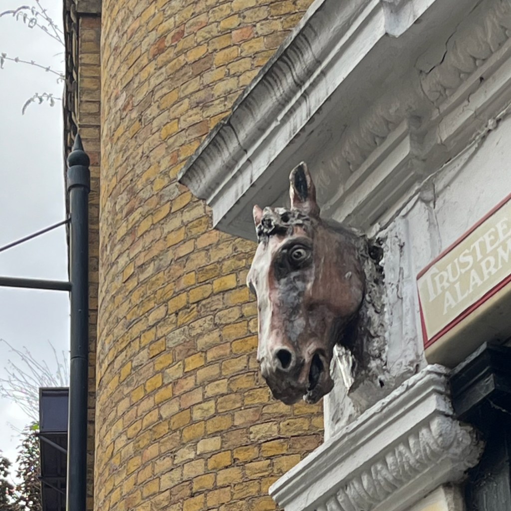
This pub was formerly The Sun, and had a magnificent painting on the corner. There are pictures and history on this detailed post from The London Inheritance. The many comments on the London Inheritance blog post describe happy memories of The Sun and its numerous Real Ale pumps.

The pub is listed Grade II reference 1379274. It was built in the early 18th century and the front was renewed in the 19th century. It was The Sun until the 1990s when the name was changed a few times, becoming the Perseverance around 2005/6.

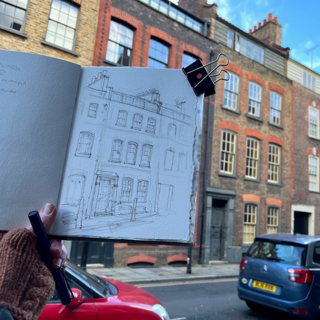
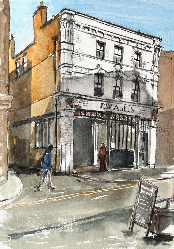
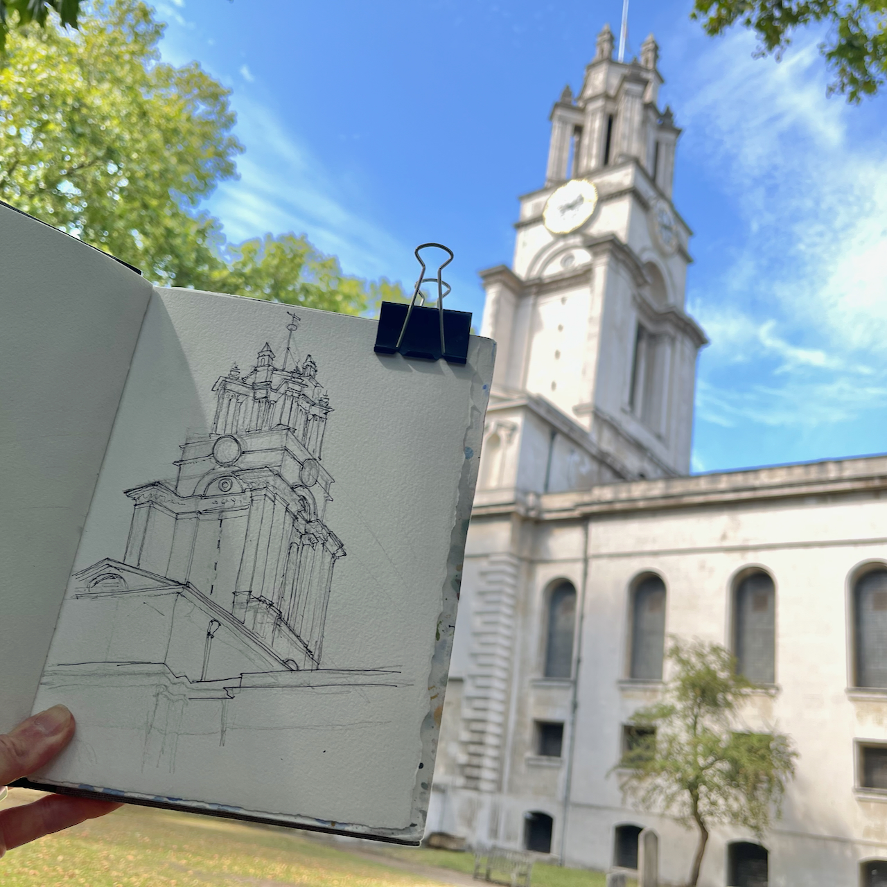
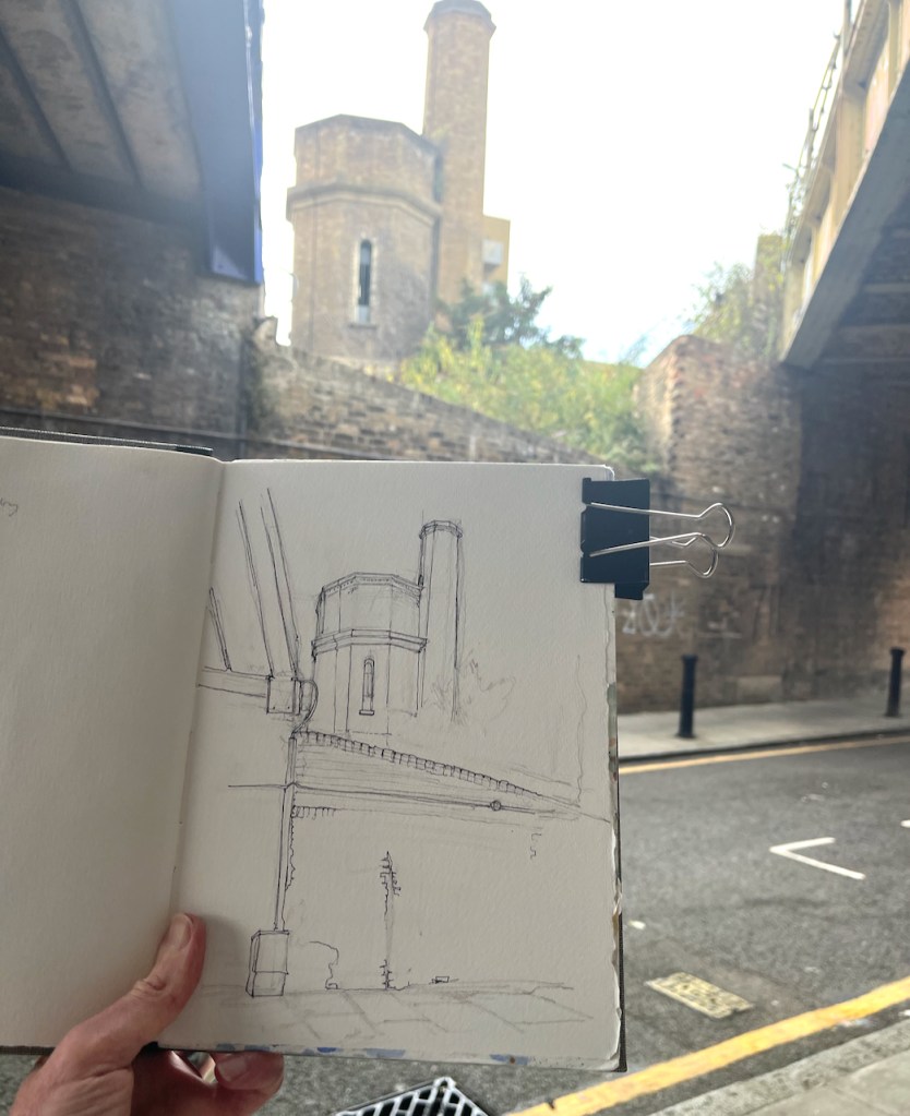
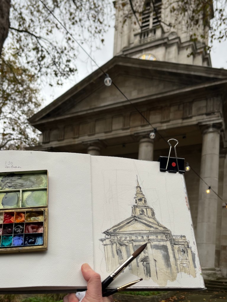
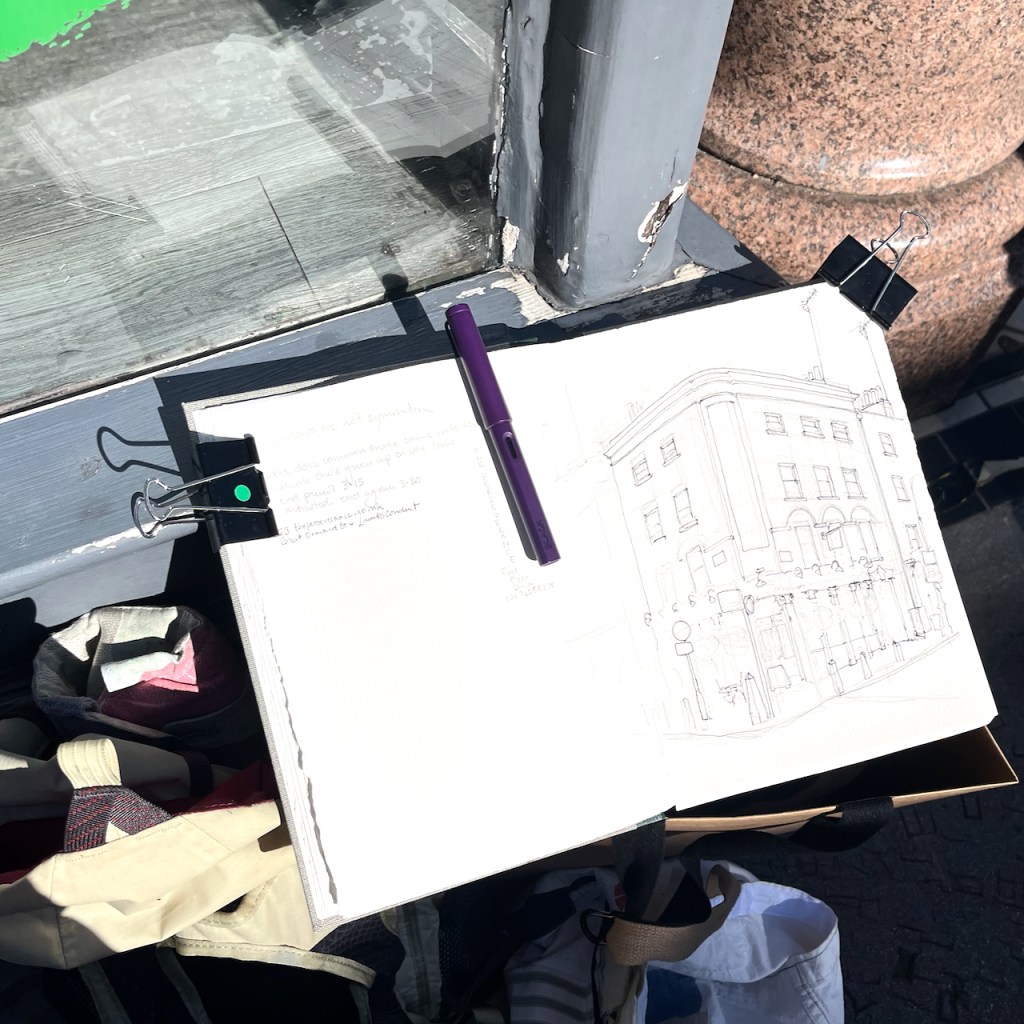
I sketched it from the “Rymans” stationery shop which is on the opposite corner of the crossroads. People walked past me, deep in conversation, casting shadows in the afternoon sun. But one elderly man stopped, and looked up at me. His back was slightly bent. “Are you alright standing there?” he asked. I said I was, wondering what he meant. “Because,” he continued, “I could go up and get you a stool from my flat. It’s just up there.” He pointed heavenwards, to the windows above the shops. People are so kind. This man was so kind. It’s moments like this which make the sun rise on humanity. I was in fact quite tired, and would have liked to sit down, but my drawing was very nearly finished. I hesitated to send this helpful individual back up his stairs. So I declined his thoughtful offer, as politely as I knew how, and continued my drawing standing upright in the sun.

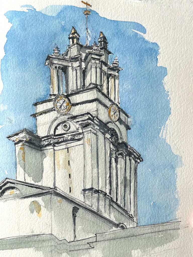
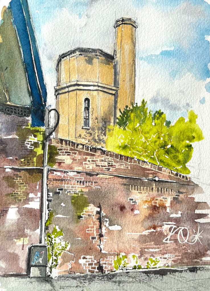
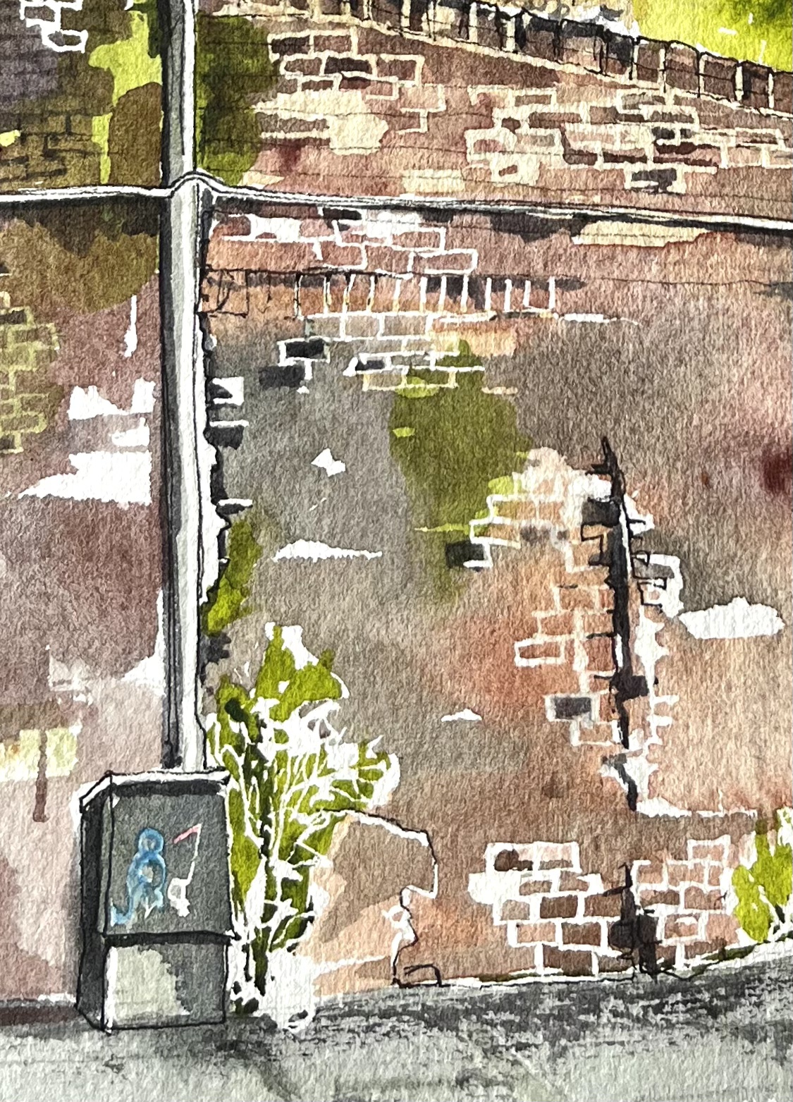
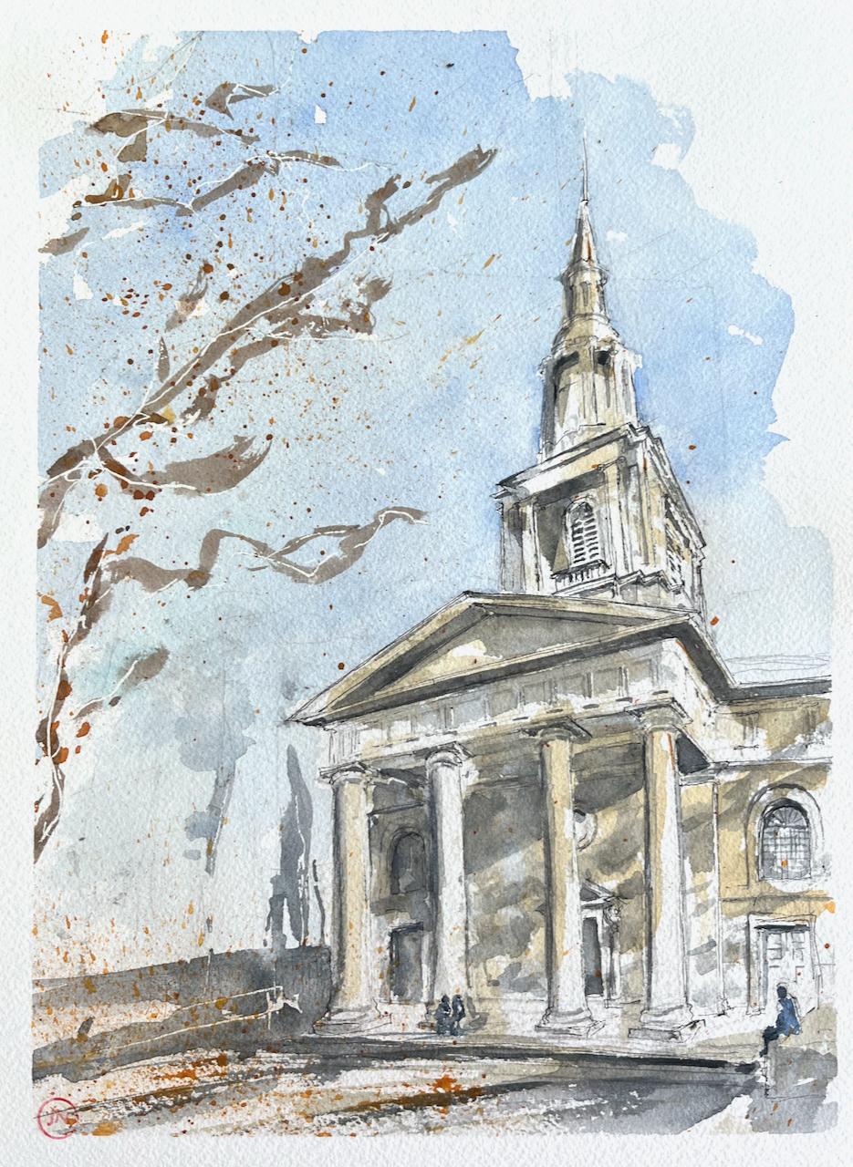
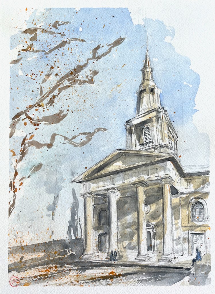
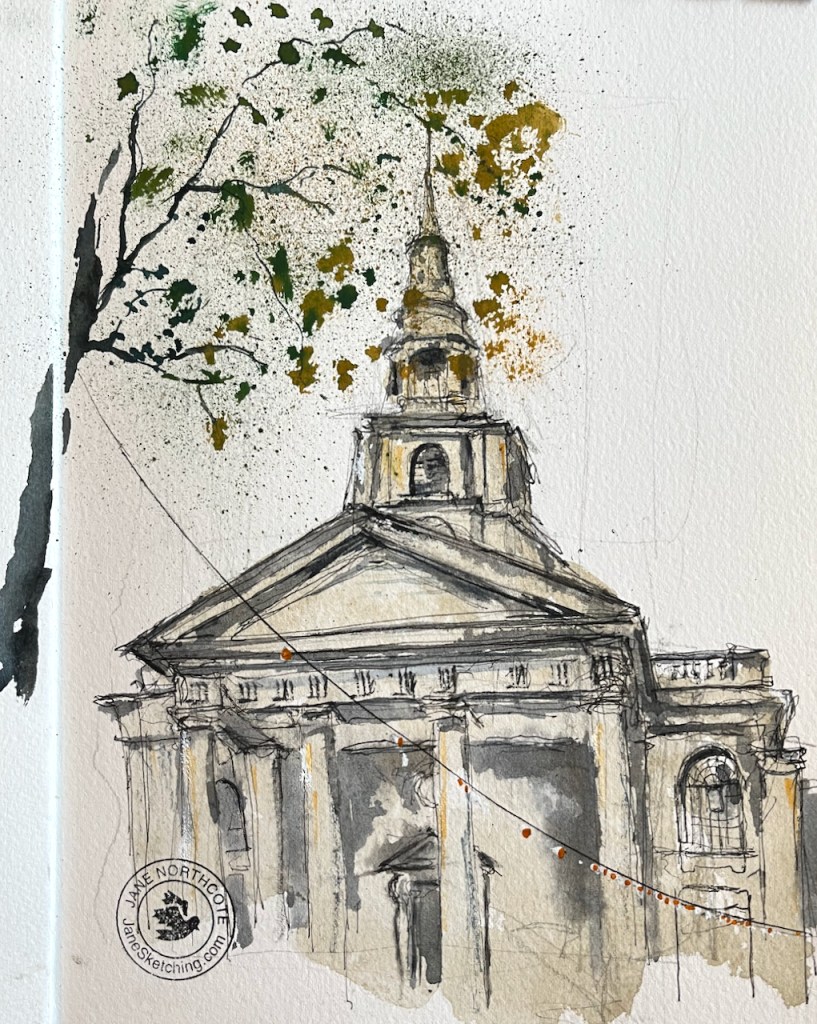
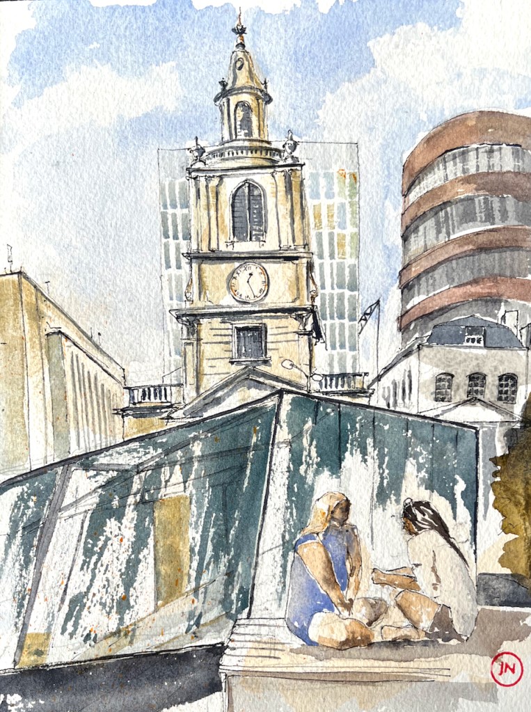
This drawing took 1 hour and 20 mins on location, plus another hour and a half at my desk later. The colours are:

  • Mars Yellow (brickwork)
  • Ultramarine Blue and Burnt Umber (mixed, for the greys and blacks)
  • Phthalo Blue Turquoise and Ultramarine Blue for the sky and the street, and the street signs
  • Transparent Pyrrol Orange for the “No Entry” sign and the flowers
  • Serpentine Genuine Green for the plants
  • A tiny bit of Permanent Yellow deep for the yellow line on the road, and other small touches
  • All whites are the paper.
  • Ink lines are De Atramentis Document black ink in an Extrafine Lamy Safari fountain pen
  • Paper is Arches Aquarelle 300gsm Cold pressed in a sketchbook made by the Wyvern Bindery in Hoxton.

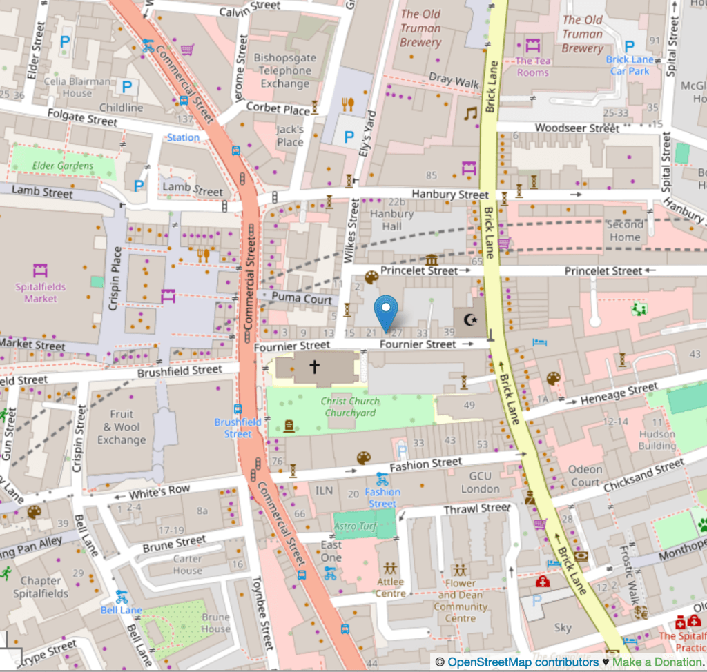
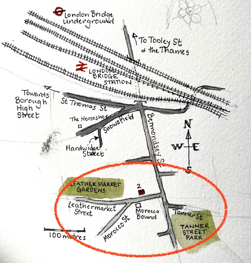
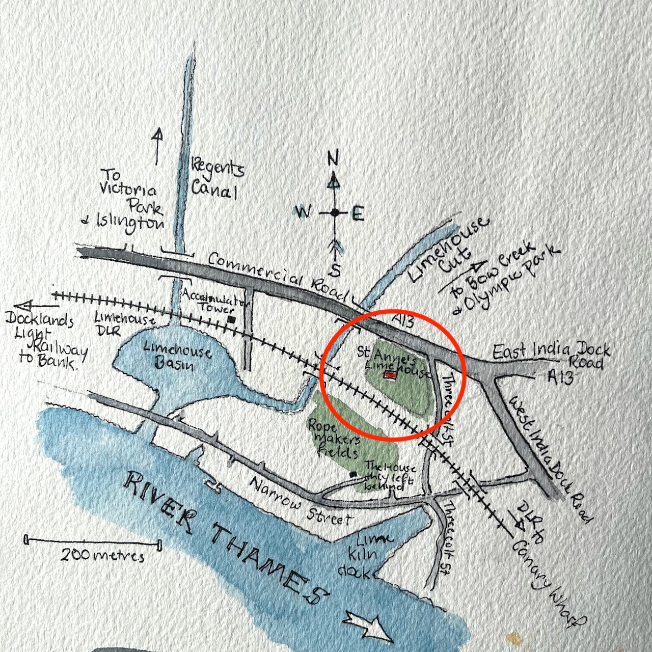
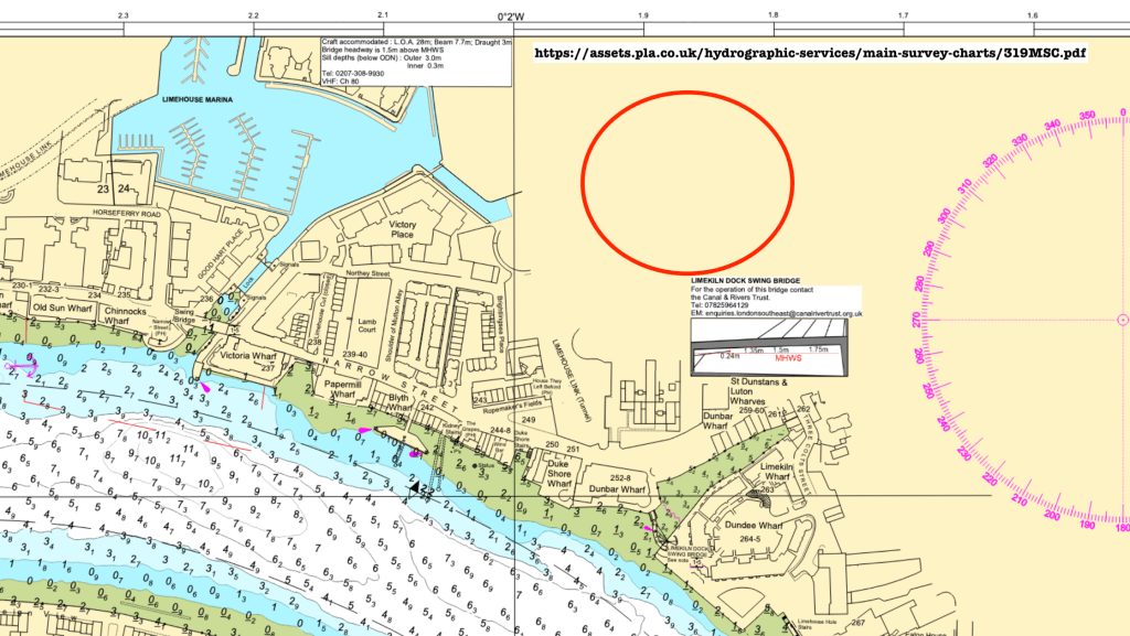
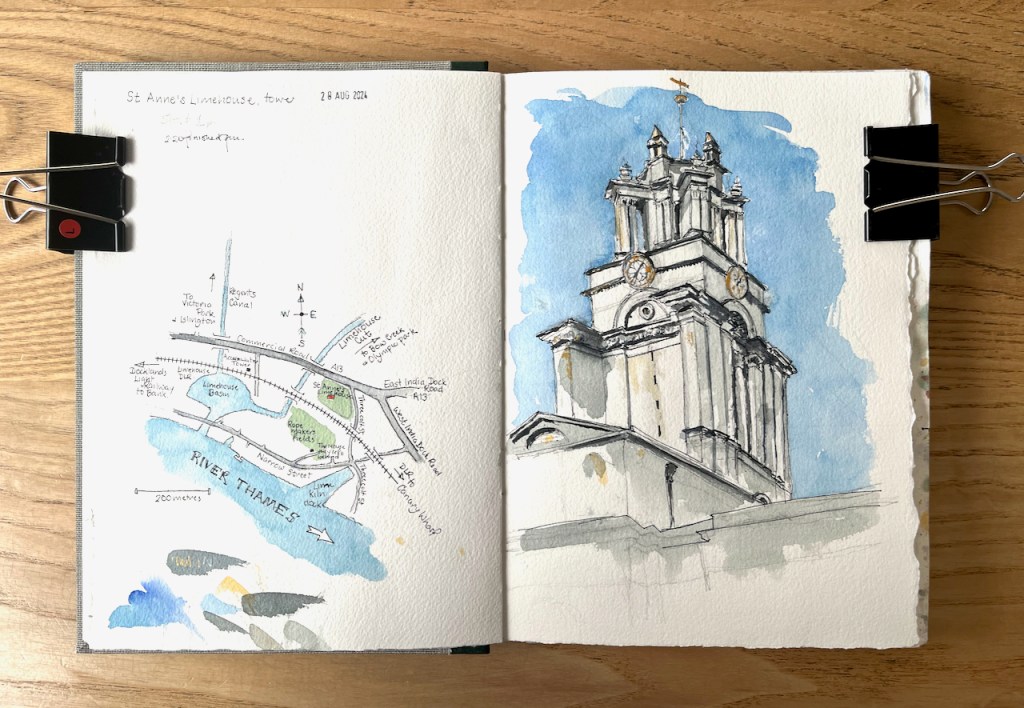
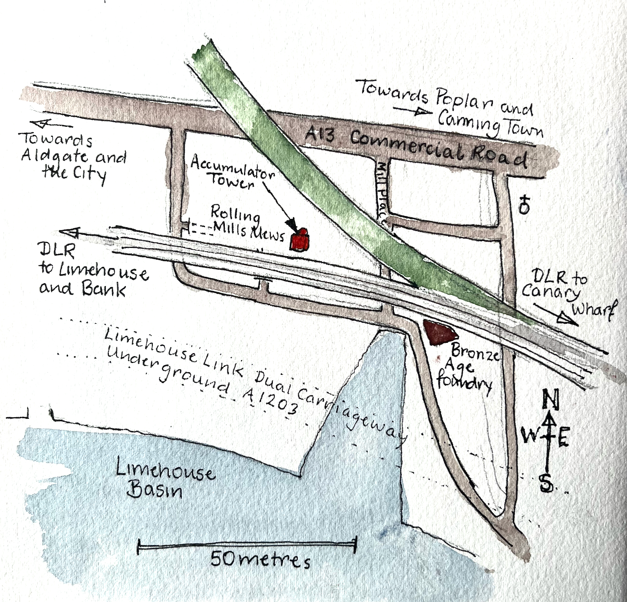
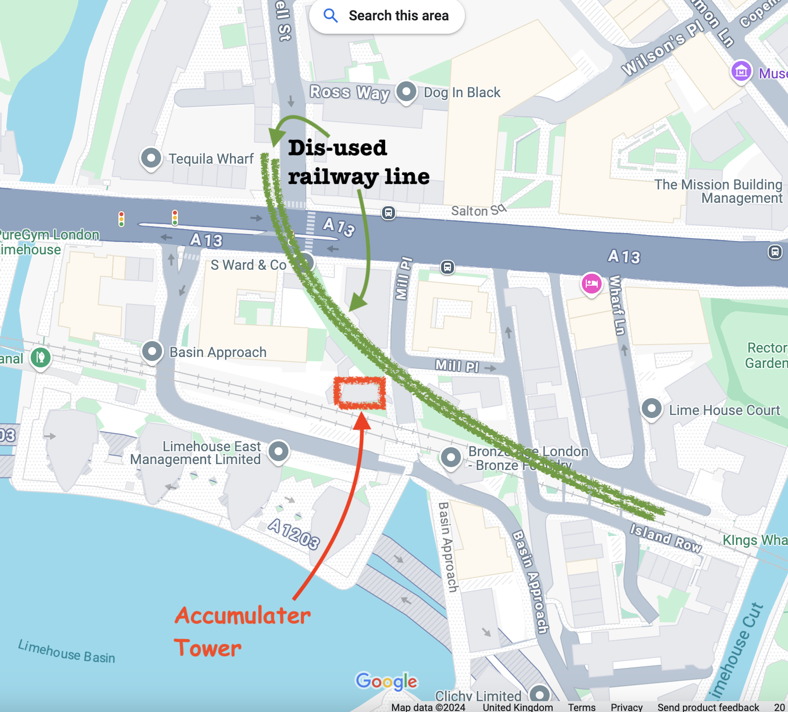
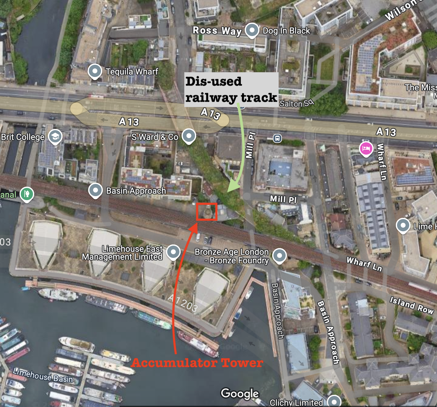
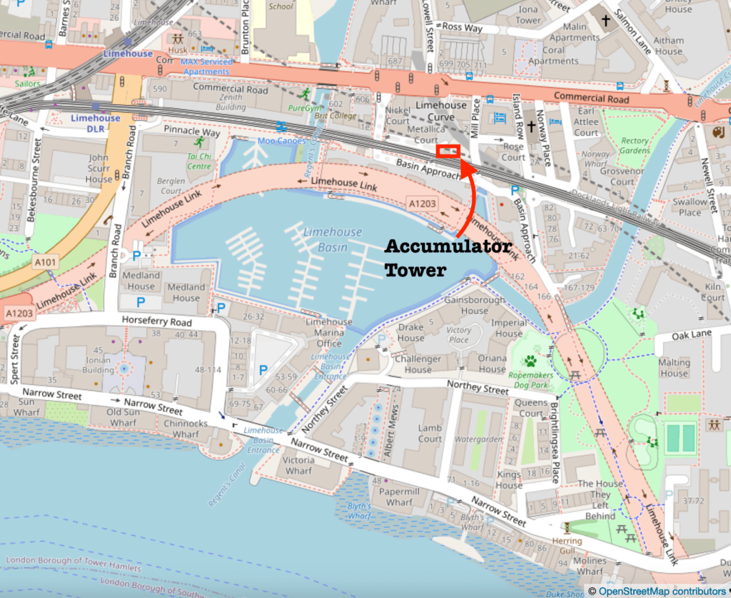
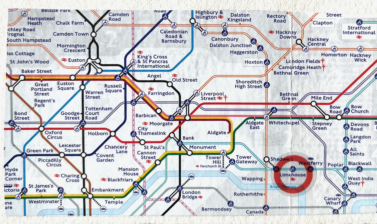
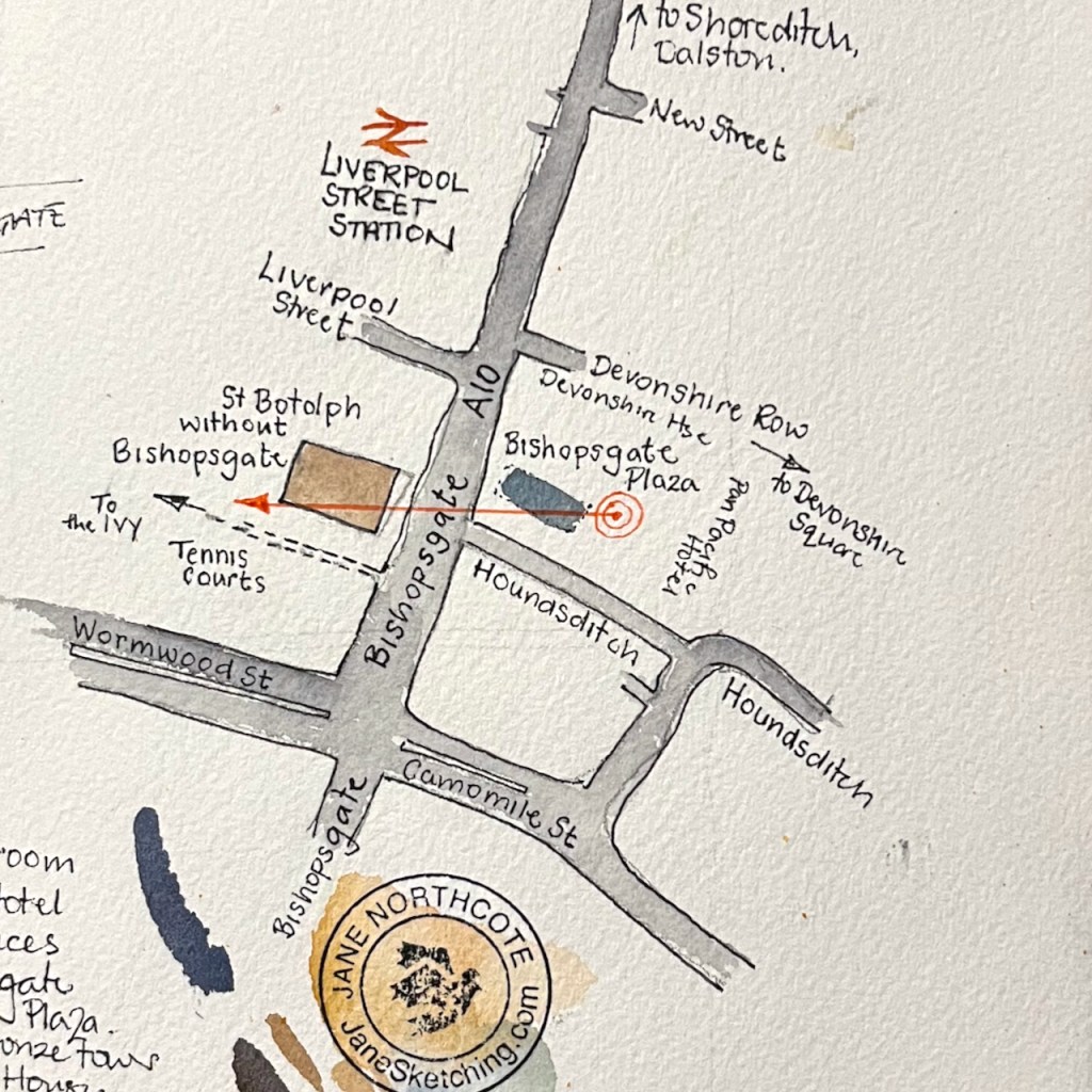
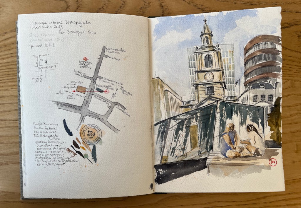
Here are maps (click to enlarge):

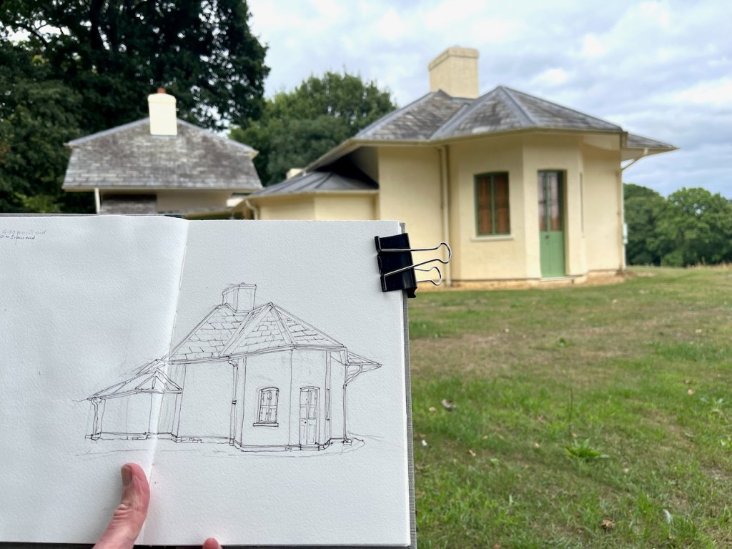
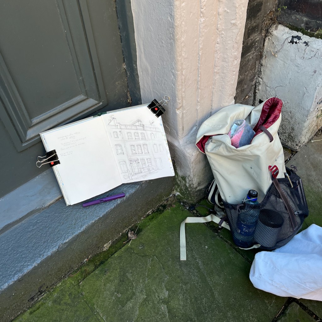
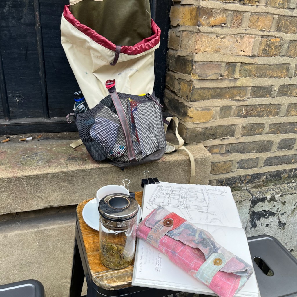
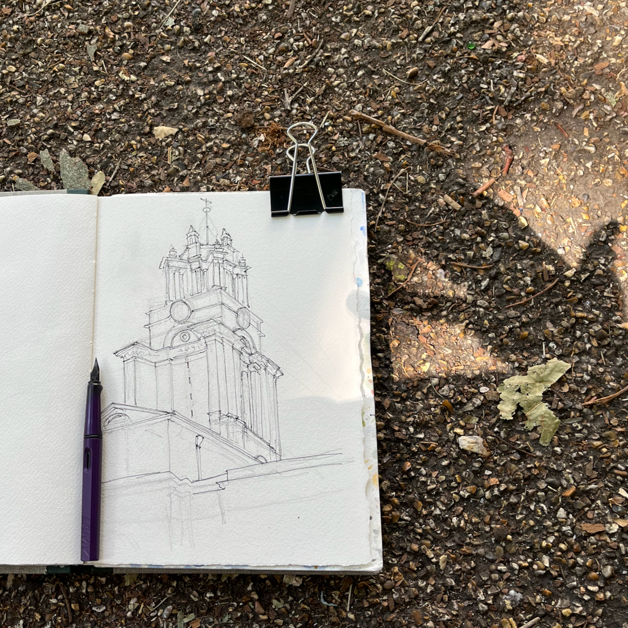
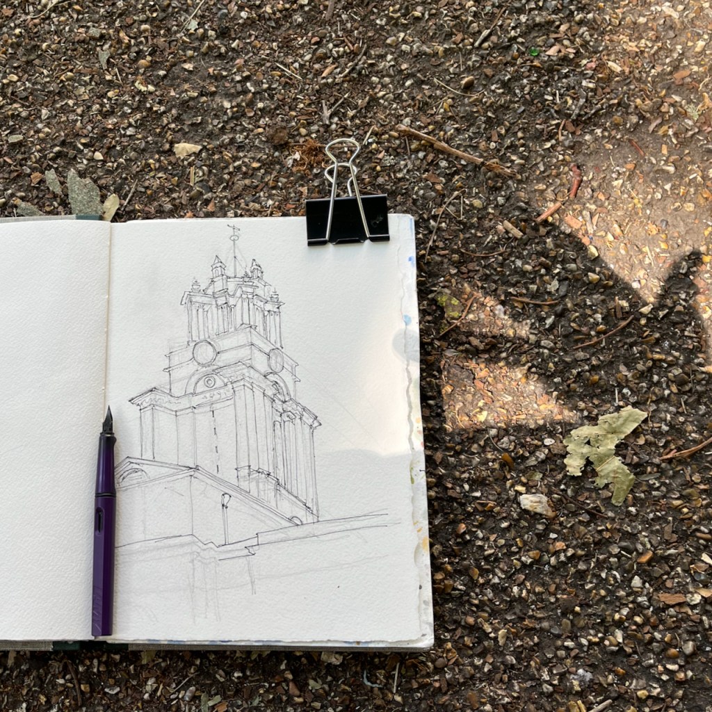
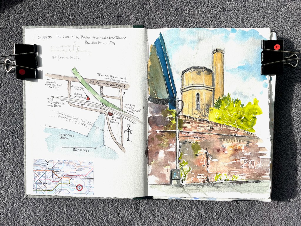
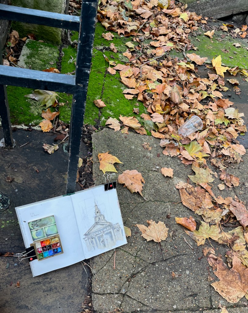
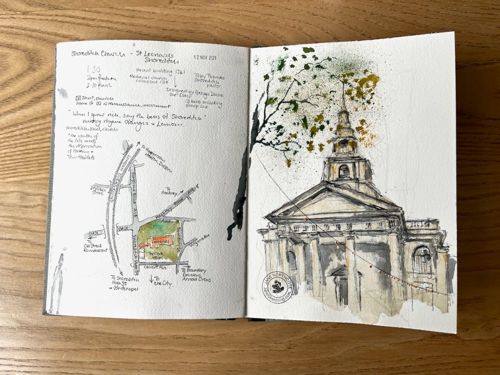
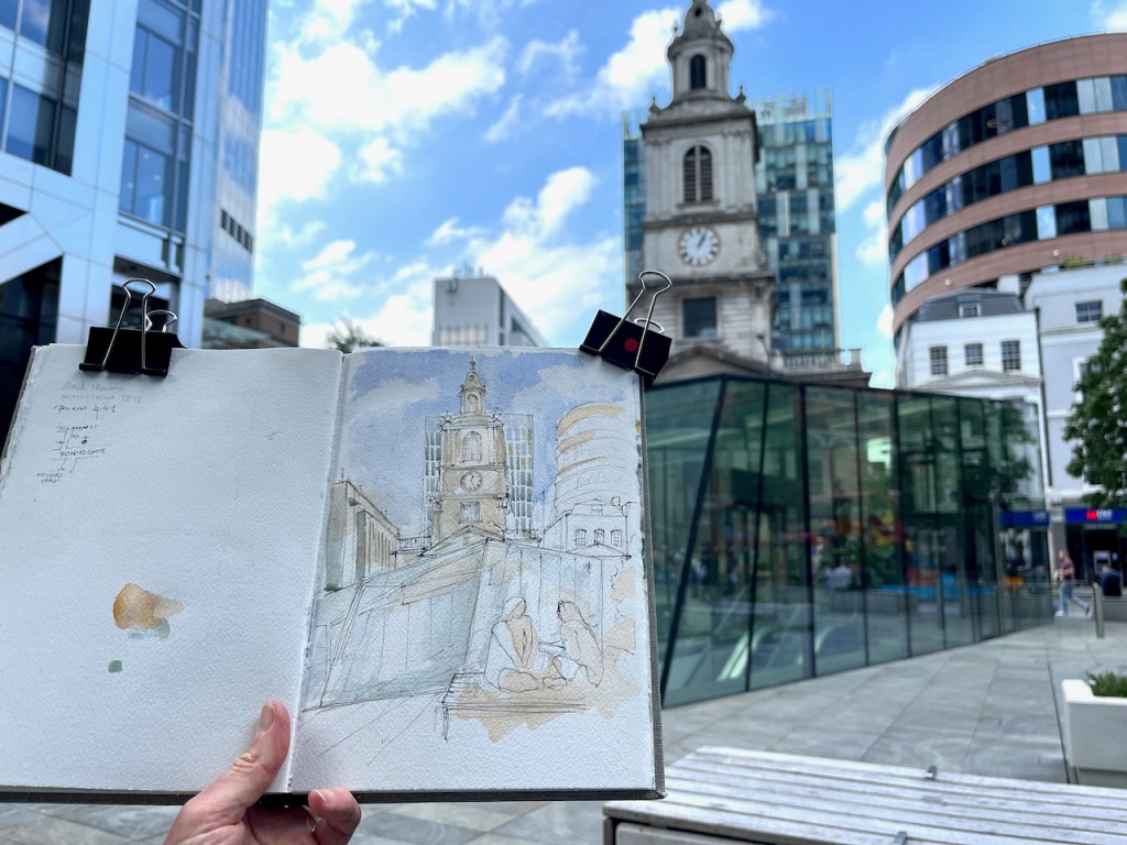
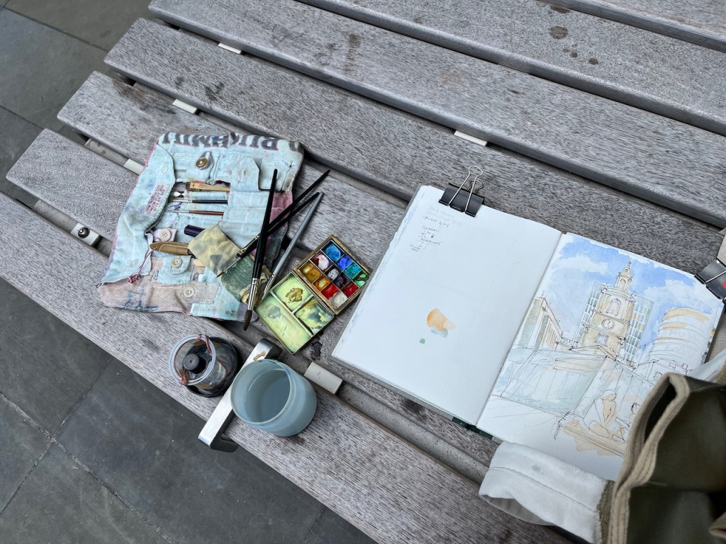
Here is the sketchbook, size 7″ x 10″.

The Dairy at Kenwood House

Lady Anne Innes-Ker, 1911 by John Singer Sargent

Kenwood House is a mansion at the top of Hampstead Heath, to the North of London. It is managed by English Heritage. At the moment there is an exhibition “Heiress: Sargent’s American Portraits”. Fantastic oil paintings, each woman with a history, echoes of the time of Henry James. Even more than the oil paintings, I enjoyed the charcoal portraits. See the character of the sitter! See the skill of the artist! Recommended: it’s on until 5th October 2025.

After that, we walked out into the late afternoon sun. Kenwood is a large building. It was too much to take on the house as a sketch project at that time of day. So I sketched a small building I’d spotted on the way in. This is “Kenwood Dairy”. I sketched just a part of it.

Kenwood Dairy, south pavilion, sketched 18 August 2025 in Sketchbook 16, approx size 9″ x 9″.

You can see the whole dairy in this oil painting of 1797 by Julius Caesar Ibbetson:1

Ibbetson, Julius Caesar; Three Long-Horned Cattle at Kenwood; English Heritage, Kenwood; http://www.artuk.org/artworks/three-long-horned-cattle-at-kenwood-191767

The pavilion I sketched is the one on the left. There were sadly no cattle, long-horned or otherwise, for me to put in my sketch.

The dairy was built in 1795, just a two years before Ibbotson’s oil painting. It was a working dairy, built to the designs of George Saunders, for Louisa, the wife of David Murray, 2nd Earl of Mansfield. It was fashionable for 18th century upper-class ladies to run dairies.

a dairymaid.. lived in the cottage and produced the fresh butter, cream, puddings and ice-cream enjoyed by the family and their guests.

English Heritage noticeboard near the dairy

These buildings are now used as a base for volunteers at Kenwood and Hampstead Heath.

Here is work in progress on the drawing:

It was quite tricky to follow the line of that roof. I managed to get the ink lines done, then it was time to go home. I added the colour later at my desk.

Kenwood dairy, finished drawing in Sketchbook 16

While I was drawing the dairy, John was drawing me, from a nearby bench.

Picture credit: John Ramsey

  1. https://commons.wikimedia.org/wiki/File:Julius_Caesar_Ibbetson_(1759-1817)_-_
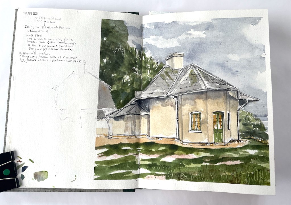
Three_Long-Horned_Cattle_at_Kenwood_-_88029298_-_Kenwood_House.jpg ↩︎

25 Fournier Street, London E1

Fournier Street is a row of 18th century houses in Spitalfields, east London. Here is number 25.

25 Fournier Street, sketched 19th December 2024 in sketchbook 15

The weather was cold, and I was sheltering from the wind in a doorway opposite.

People rushed past on the pavement in front of me. It was nearing Christmas. I caught fragments of conversation. “Everyone’s after money” said a woman to her companion, “and it’s wrong!“.

I enjoyed spending time looking at this elegant house. The tops of the windows are curved. This is quite common in London. What is unusual here is that the wooden window frames are also curved, and the top panes of glass are curved to match. This must make replacing the glass quite a labour, I thought, and the curved sash window frames would need a skilled carpenter.

A woman approached, looking bothered. She caught sight of me in my doorway. I thought she wanted to open the door where I was standing, to enter the house behind me. So I was ready to express my apologies and move my stuff out of the way. But no, she wanted directions to Brick Lane, which is at the end of Fournier Street. “Just there,” I said, pointing. Brick Lane was almost visible, in a straight line from where we were standing.

She was flustered and didn’t seem quite to believe my simple direction. “It’s all changed round here!” she objected. I paused.

This street has hardly changed in 300 years. I’d just spent an hour looking at a house that was built in 1727. But I didn’t say that: a latent voice episode1.

She was an artist too, she told me. She was looking for a gallery. She hurried off, in the direction I’d indicated.

I was left looking at the house, and thinking.

  1. latent voice episodes = “potential communications that may or may not in fact occur”, Harvard Business School paper: Working Knowledge, Q&A with Amy C. Edmondson, author: Sarah Jane Gilbert, March 20, 2006. “Latent voice episodes” is a useful concept, I think. It’s for those times when you might speak, but don’t. ↩︎

2 Morocco Street, Bermondsey, London SE1

Bermondsey is an area of London just to the south of London Bridge. I had tea at the bookshop and café called “Morocco Bound”. From a table outside Morocco Bound, I sketched the building opposite.

2 Morocco Street, sketched from “Morocco Bound”, 18th October 2024, 2pm in Sketchbook 15

As you see, on the ground floor there is a motor repair shop, “R.W. Auto’s”.

RW Autos is Southwark’s top garage offering a range of car services including MOT’s, repairs and servicing. Our Southwark garage has been established since 1969 and serves a plethora of private and corporate clients. Our team provide you with a friendly, reliable, personal, efficient, and affordable service.

RW Autos website

The names of the streets round here indicate the historic industry of the area: tanning and leather making: Leathermarket Street, Tanner Street, Morocco Street.

A 1967 Webster’s dictionary, morocco bound. Source: for sale on James Cummins bookseller website (30 Oct 2024)

I was sketching on Morocco Street. Morocco is a type of soft leather. It is used for gloves and wallets, for example. It is also used for book bindings, hence the name of the café: ‘Morocco Bound”. According to the “Medieval and Early Modern Orients (MEMOs)” scholarly site1, Morocco leather was originally “a kind of extremely fine, soft, hard-wearing, and richly dyed sumac-tanned goatskin, originating in the Sokoto region of northern Nigeria, transported across the Sahara and exported to Europe by Maghrebi, particularly Moroccan, merchants.”. This was in the 16th and 17th centuries.

This luxury product was greatly imitated over the following years, so that “by the turn of the nineteenth century, nearly all obvious distinctions between imported and locally produced morocco leather had been erased, and to many modern curators, ‘morocco’ refers either to the distinctive grain, or simply to goat leather bindings, whatever their origin.”

Books are still bound in “morocco leather” today.

The phrase “Morocco bound” occurs in a song from the 1942 film “Road to Morocco” with Bing Crosby, Bob Hope and Dorothy Lamour. Here is an extract:

We may run into villains but we're not afraid to roam
Because we read the story and we end up safe at home
Certainly do get around
Like Webster's Dictionary we're Morocco bound

We certainly do get around
Like a complete set of Shakespeare that you get
In the corner drugstore for a dollar ninety-eight
We're Morocco bound

Or, like a volume of Omar Khayyam that you buy in the
Department store at Christmas time for your cousin Julia
We're Morocco bound....

It was only when I started looking at the building carefully that I noticed the horses’ heads. It turns out these are a bit of a mystery.

The mystery of the Horses’ Heads

I found this 1976 photo in the London Picture Archives, reproduced here with permission:

1976 photo, Building in Morocco Street, record number 51956
image source: (c) The London Archives (City of London Corporation), picture used under licence reference #007089
https://www.londonpicturearchive.org.uk/view-item?i=54304&WINID=1730309548612

You see Number 2 on the right of the photo, looking very much as it does today. Except that there are no horses’ heads. When did they appear?

Various websites2 suggest that Number 2 Morocco Street was “once a smithy”. If this was a smithy with horses’ heads in (say) the early twentieth century, then someone removed them before the photo was taken in 1976, and has put them back some time afterwards. Or the building became a smithy after 1976, in which case it must have been one of the very few left in London at that time. Or the horses’ heads are a recent decorative addition and not related to the original purpose of the building atall. It’s a mystery. Next time I am in the area I will go and enquire at R.W. Auto’s.


  1. Medieval and Early Modern Orients (MEMOs) is an AHRC-funded decolonial project that seeks to further knowledge and understanding of the early interactions between England and the Islamic Worlds. AHRC is the Arts and Humanities Research Council. The quotations come from an article on their site entitled “Morocco Leather and Material Understandings of the Maghreb in Early Modern Britain” dated 14 November 2022 on this link: https://memorients.com/articles/morocco-leather-and-material-understandings-of-the-maghreb-in-early-modern-britain ↩︎
  2. Various websites suggest that this building was once a smithy. Here are the links:
    Layers of London: https://www.layersoflondon.org/map/records/morocco-street. “2a R.W.Autos with horses heads was a smithy/farrier”
    Bermondsey Boy: http://www.bermondseyboy.net/viewtopic.php?t=260. This website includes a photo from 2015 – with horses heads, and the commentary. “RW AUTO’S The two horse heads above the front of this garage workshop are the last clue that is was once a smithy – a blacksmiths.” This website also includes a 1968 photo which has no horses heads. ↩︎
Sketchbook 15 page spread

Tower of St Anne’s Church Limehouse, E14

This is the tower of St Anne’s Church Limehouse, seen from the south.
St Anne’s is a church designed by Nicholas Hawksmoor, consecrated in 1730.

St Anne’s Church Limehouse tower, sketched 28 August 2024 in sketchbook 15

This tower shows the marine connections of this church:

The prominent tower with its golden ball on the flagpole became a Trinity House “sea mark” on navigational charts and the Queens Regulations still permit St Anne’s Limehouse to display the White Ensign”.

Wikipedia (1 October 2024)
White ensign

The White Ensign is definitely flying. In my drawing the flag is blowing away from me, so you can’t see it well. It is the flag flown by British Navy ships and certain navy-related buildings on land, of which St Anne’s in one.

The golden ball is clearly visible on the flagpole, the “sea mark” mentioned in articles about the church. I had a look to see if I could find St Anne’s on a navigational chart. The Port of London Authority offers navigational maps of the Thames – but sadly St Anne’s is not shown as a “sea mark” on any of them.

Detail from Chart 319 from the Port of London Authority. The red circle where St Anne’s is, but it’s not shown as a “sea mark”.

The church has a lovely quiet garden. I sketched from the wooden seat, watched by a robin.

Sketchbook 15

Here are other sketches I’ve done around Limehouse and Wapping, near here:

Limehouse Accumulator Tower, E14

This is the Limehouse Accumulator Tower, seen from Mill Place, London E14.

Limehouse Accumulator Tower, sketched 21 August 2024, in Sketchbook 15

In the 19th century, this building provided hydraulic power to machinery in the Limehouse docks. Hydraulic power is a way of transmitting energy from one place to another.

The problem at the time was that steam engines could generate motive force, but only where they were. You could build a big powerful steam engine, but you couldn’t put a steam engine next to every crane, capstan, or set of lock gates. You also didn’t want to fire up a steam engine every time someone wanted to use the lock gates. So you had to find a way of transmitting the power from the steam engine to the machinery which used it. And you had to find a way of storing the power so it was available on demand. Before the use of electricity was common, power was transmitted using pressurized water.

The steam engine located in this building was used to pump water into the adjacent accumulator tower, by lifting a heavy weight. The heavy weight was a neat fit on top of the water inside the tower and pushed the water down. Water does not compress. So the weight just sat there, applying pressure to the water. The pressurised water was distributed around the docks in thick cast-iron pipes. When the lock-keeper wanted to operate the lock gates they opened a tap and the force of the pressurized water opened the gates. Then they closed the taps. Far away, the weight moved down very slightly in the accumulator tower. Eventually the steam engine was used to pull the weight up to the top again.

That’s 19th century hydraulic power. Power is transmitted by pressurised water in cast-iron pipes: the original, functional, steam-punk.

I find it marvellous. I’ve drawn the much bigger London Hydraulic Power station here. The Limehouse building is smaller. It was built in 1869, one of several in the area at the time. It was restored in 1994/5, but sadly the weight and machinery are removed. There is a detailed history of the building on this link from the Greater London Industrial Archaeology Society.

Sketching the Limehouse Accumulator Tower. The modern Docklands Light Railway lines run over the Victorian bridge to the left, the bridge to the right is disused.

Standing in Mill Place to make this sketch, I became aware of all the history that is embedded in walls. The one in front of me had been altered, rebuilt, and amended several times. A bit had been added on top. Plants lived there. A graffiti artist had made their mark on the crumbling stone.

I was standing under two bridges, both 19th century. Both survivors. One holds the modern Docklands Light Railway. The other had wonderful strong vaulting. But it held no railway. I walked around trying to find out where it went. The Google aerial view confirms what I suspected: it is a ghost railway. On the bridge there is verdant greenery where the railway used to be. It goes across a second sturdy bridge, over the A13, and then stops.

Here are some maps which show the position of the Accumulator Tower and the absence of a railway (click to enlarge).

In this whole area the works of Victorian engineers make themselves felt. Each bridge is a triumph of the bricklayers’ skill: not only strikingly beautiful, with clean curves and neat detailing, but also enduring, powerful and functional 150 years later.

Sketchbook 15
map (c) OpenStreetMap contributors: click to go to the map

Tin Tabernacle, St George’s West End, Esher KT10 8LF

Beside the green on the West side of Esher stands this iron church, St George’s West End.

St George’s West End, Esher. Sketched on location February 2024, in Sketchbook 14

It has a single bell in its small bell tower, and a fence made in a particular way, which I tried hard to show. I wondered if it is intentionally in the shape of a line of crosses, appropriate for a Christian church.

This is one of dozens of “tin tabernacles” or iron churches across the UK. Wikipedia has a whole list. Some of them are strikingly similar to this one.

They were built in the late 19th century, in response to expanding demand, using the new technology of corrugated iron. Many of them, including this one, were pre-fabricated.

According to a 2004 article on this church by Angela Stockbridge the land was donated by Queen Victoria in 1878. “A need was felt to make provision for “the spiritual wants of the “Aged, Poor and Infirm of West End”” and to spare them from the steep and often muddy climb into Esher” she writes. It was intended to be a temporary church. 145 years later, here it is, still standing, and still hosting services.

The church is dedicated to St George. Above the porch is a stained glass window, evidently showing the Knight slaughtering the Dragon. I could just make him out standing on the stirrups of his white horse. The church was closed when I visited, but I hope to go inside on a future occasion. I am told that inside it is cladded with white-painted wood panelling.

I sketched the church from the village green opposite. It was damp and muddy. When I’d had enough, I retreated to the “Prince of Wales” for some lunch. Then I went on to sketch the church in Esher town centre: another St George’s.

Esher is to the West of London, with a main line railway station in to Waterloo.

“They do tend to heat up in summer and stay cold in winter, and the rain makes a noise on their roofs, but they have proved remarkably sturdy. As one commentator writes, “Tin Tabernacles are an important if brief and overlooked episode in the history of church architecture,” and have a claim to “be recognised as listed buildings, particularly as examples of prefabrication” (Dopson 204-05).”
Dopson, Laurence. “Tin Tabernacles.” Words from “The Countryman”. Ed. Valerie Porter. Newton Abbot: David & Charles, 2007. 204-05.

https://victorianweb.org/art/architecture/churches/58.html
In the “Prince of Wales”

St Clement Danes, Strand, WC2

St Clement Danes stands on a traffic island in the Strand.

St Clement Danes, Strand, WC2R 1DH, sketched 7 February 2024 13:30 in sketchbook 14

I sketched this church over a lunchtime. At 1pm its bells played its tune, “Oranges and Lemons“, a little haphazardly, but quite distinct.

Why St Clement Danes? What’s Danish about it? According to the church leaflet, in the 9th century, “Danish settlers who had married English wives were allowed to settle in the area taking over a small church dedicated to St Clement. The Church came to be known as ‘St-Clement-of-the-Danes'”.
A rather more brutal story is told by the Viking Ship museum of Roskilde in Denmark:

“By the 9th century London was yet again a powerful and wealthy town attracting the attention of the Danish Vikings. They attacked London in AD 842, and again in AD 851, and The Great Army spent the winter in the town in AD 871-72.”
“Cnut became King of England and in AD 1018 he was able to send his army back to Denmark. He burdened the English population with the tax thingild to pay for the maintenance of a small army. He also placed his Danish garrisons around London, including by the church St. Clemens Danes. Generally, Cnut was a popular king, and during his reign peace prevailed in England. Cnut died in AD 1035 and one of his sons, Harold Harefoot, took over the English throne.
On his death Harefoot he was buried in Westminster Church, but his brother Harthacnut ordered the body to be dug up and thrown into the Thames. Perhaps Harold Harefoot was re-buried in St. Clemens Danes outside the town wall. The peace in England was over.”

The “Science Nordic” site offers lively descriptions of the Danish people that arrived in England in the 9th and 10th centuries. Today we might describe them as “economic migrants”

“In eastern England the Vikings discovered a milder climate and a rich agricultural landscape, similar to the one they knew back home. Faced with a lack of good farming land in Denmark, many families decided to try their luck on the other side of the North Sea.”
Dr Jane Kershaw, Archaeologist and Viking researcher

St Clements no longer has any particular Danish connection. It is linked to the Royal Air Force. The statue outside, in the bottom centre of my sketch, is

“Air Chief Marshall Lord Downing, Baron of Bentley Priory, Fighter Command 1936-40”

according to the inscription on his plinth. The Danish church in London is St Katherines, to the East of Regents Park.

Here is the song the bells played, with links to my drawings of the churches:

Oranges and lemons,
Say the bells of St. Clement’s. (St Clement Danes)
You owe me five farthings,
Say the bells of St. Martin’s. (St Martin in the Fields)
When will you pay me?
Say the bells at Old Bailey. (St Sepulchre-without-Newgate)
When I grow rich,
Say the bells at Shoreditch. (St Leonard Shoreditch)
When will that be?
Say the bells of Stepney.(St Dunstan’s Stepney)
I do not know,
Says the great bell at Bow. (St Mary Le Bow)
Here comes a candle to light you to bed,
And here comes a chopper to chop off your head!

Shoreditch Church: St Leonard E1

Here is St Leonard Shoreditch, which stands at the intersection of Shoreditch High St and the Hackney Road, postcode E1 6JN.

St Leonard’s, Shoreditch Church sketched 23 November 2023, 12″ x 9″ [sold]

There has been a Christian church here since medieval times. The present building dates from 1741 and was designed by George Dance the Elder (1695-1768). George Dance the Elder was the City of London surveyor at the time, and designed, amongst other buildings, Mansion House at Bank Junction.

The current church is active in the community. On the day I was sketching, a Thursday, they were offering meals to local people. This is the Lighthouse Project, “providing practical help, food parcels and hot meals to local people in need” according to their website. You can see several guests in the picture.

Placard offering "Free Community meal for the people of East London"

When the church was recently rebuilt at the turn of the millenium, a large amount of money was spent on its community needs and no funds were left to buy paint. Hence it still looks a bit bohemian. We think it’s quite endearing and shows people where our priorities are – with the community rather than how we look.

The current community is highly diverse. The wealth of the City meets the deprivation of Hackney and Tower Hamlets. Our neighbours in Arnold Circus and St Hilda’s Community Centre are highly galvanised community groups acting for societal change.

Shoreditch Church website (https://shoreditch.saint.church/new-page-50)

This church houses the “bells of Shoreditch” from the children’s song “Oranges and Lemons”. If you go inside the church you can see a bell, which is resting on a wooden pallet on the right hand side of the nave.

when I grow rich, say the bells of Shoreditch.

The Society of Cumbernauld Youths in 1784 rang a complete peal of 12000 changes of Treble Bob Royal, taking nine hours and and five minutes.

Oranges and lemons,
Say the bells of St. Clement’s. (St Clement Danes)
You owe me five farthings,
Say the bells of St. Martin’s. (St Martin in the Fields)
When will you pay me?
Say the bells at Old Bailey. (St Sepulchre-without-Newgate)
When I grow rich,
Say the bells at Shoreditch. (St Leonard Shoreditch)
When will that be?
Say the bells of Stepney.(St Dunstan’s Stepney)
I do not know,
Says the great bell at Bow. (St Mary Le Bow)
Here comes a candle to light you to bed,
And here comes a chopper to chop off your head!

The Society of Cumbernauld Youths in 1784 rang a complete peal of 12000 changes of Treble Bob Royal, taking nine hours and and five minutes, according to a placard in the church porch.

The bells are still rung.

This picture was a commission. My client was keen to have this upward view showing the front of the church. I did some practice sketches to understand the tricky upward perspective.

Thank you to my client for suggesting I draw this inspiring church, and for their permission to publish the photos of the drawing online.

Here is a map showing the location:

There is a current exhibition in the Guildhall London:

“Treasures of Gold and Silver Wire”
curated by Dr. Karen Watts, Emeritus at the Royal Armouries. It celebrates the 400 anniversary of the Worshipful Company of Gold and Silver Wyre Drawers.

In that exhibition there is a cope, a cape for the Bishop of London, showing 73 London Churches. To my delight, St Leonard Shoreditch features, on the right shoulder. It was designed by British embroiderer Beryl Dean and made by needlework students of the Stanhope Institute. (https://trc-leiden.nl/trc-needles/individual-textiles-and-textile-types/commemorative-and-commissioned-textiles/silver-jubilee-cope-and-mitre)

Having myself had a go at depicting those arches and columns on the spire, I am full of admiration for the embroiderers who managed to create an accurate image in wire thread. Hugely accomplished! The exhibition is on until 31st December 2023- well worth seeing.

St Botolph-without-Bishopsgate, EC2

Bishopsgate Plaza is on the East side of Bishopsgate, near Liverpool Street. From the seats there, here is the view of St Botolph-without-Bishopsgate. I sketched amongst the many people enjoying the sun at lunchtime.

St Botolph-without-Bishopsgate, EC2. 15th September 2023, 1pm. 10″x 7″ in sketchbook 13

The current church was constructed in 1729, to the designs of James Gould. There has been a place of Christian worship on this site since Roman times. The parish registers are complete from 1558 according to the church’s website.

Viewed from Bishopsgate Plaza, the church is all but submerged in the surrounding buildings. The large glass structure is the entrance to the “Pacific Ballroom”. This is part of the Pan Pacific Hotel, which was behind me as I sketched.

I find it quite hard to draw people, but I wanted to include the discussion between the two women. Their lively conversation contrasted with the stillness of the church, and the enormity of the buildings all around. They created a little private world between themselves.

Here is work in progress on the sketch: