Helen went off to take a conference call, and I drew the Cathedral.
This was a quick sketch, pen and wash, about 40 minutes.
While I drew this, a brass band was practising in the nearby boys’ school. They were playing “Annie Laurie”.
This cathedral is impressively enormous. The Tower is Norman: built 1077 – 1093. The nave is hugely long, but inside it is divided by screens, so you can’t see all the way along, which is what I wanted to do.
Click a button below to share this post online, email it, or print it:
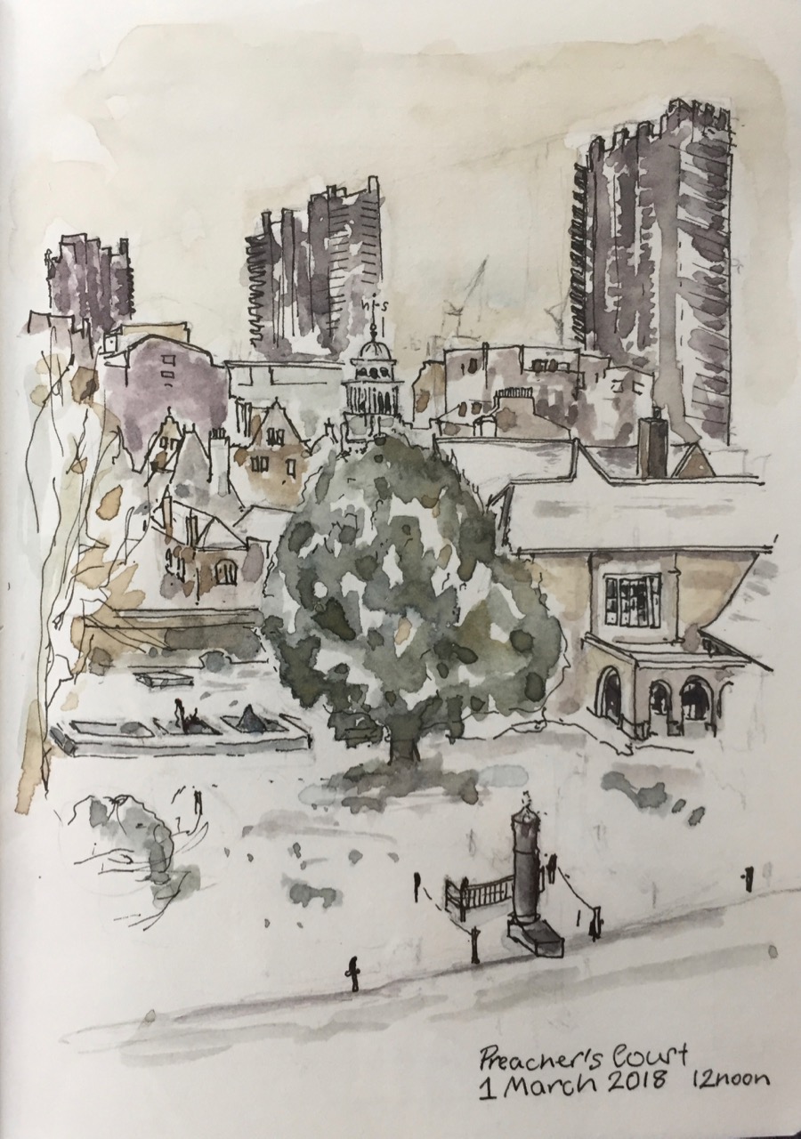
It has been snowing now for several days. Robin invited me to sketch The Charterhouse in the snow, and suggested a viewpoint from the second floor of the Infirmary.
From here I could see all three of the Barbican Towers. Someone was clearing snow in the foreground, but they moved on before I could get them in the picture.
It was a good place to sketch, warm and quiet. I could hear the muffled sounds of the nurses moving about below, and of the Brothers who were in the infirmary. Sometimes they called out.
Here is what the picture looked like before the colour went on.
This picture took about 2 hours: One hour for the pencil outline, half an hour for the pen, and half an hour for the colour – roughly. It took ages to get the proportions right. Especially in the snow, the eye sees detail in far-away objects, so the temptation is to draw them too big.
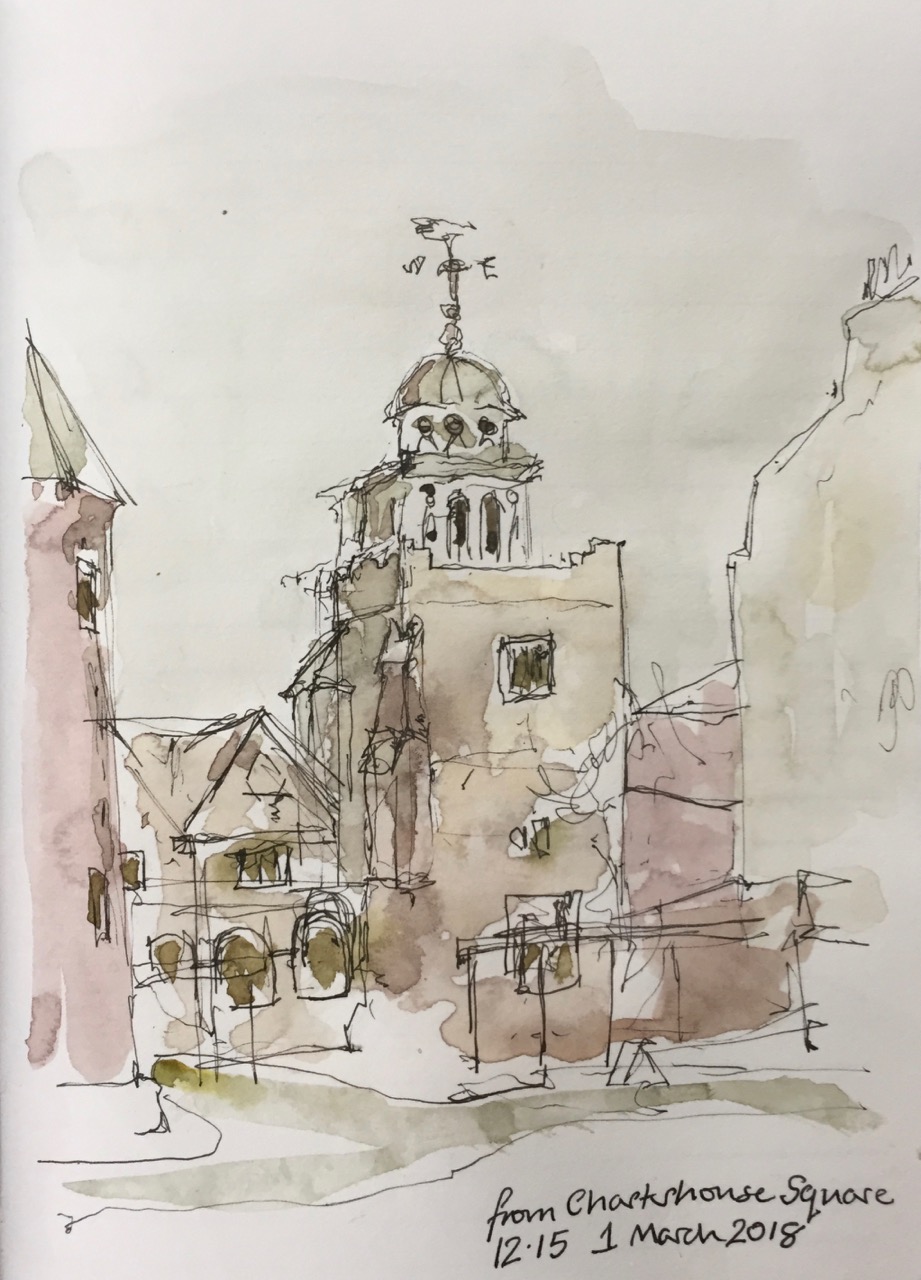
After I handed in my visitor’s badge at the gate, I went out into Charterhouse Square. I looked back at the Chapel. And did a quick pen sketch, standing in the snow.
This took about 10 minutes, coloured later on my desk at home.
Thank you to Robin, and to the Brothers, Master and staff at the Charterhouse for their hospitality.
Click a button below to share this post online, email it, or print it:
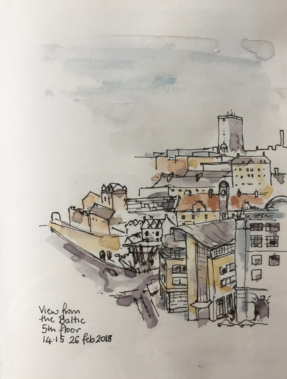
From the window of the B&B we saw the snow storm come from the East.
I drew a picture from indoors on the 5th floor of the Baltic Art building.
On the horizon is Bewick Court, 21 storeys, 133 flats, 1969-71, renovated 2002, managed by “Places for People”.
The building with the clock tower is Keelmans Hospital 1701-4. It was paid for by levying a penny a tide on the keelsmen who carried goods between large ships and the shore – in boats called keels. This information from the Pevsner guide to Newcastle and Gateshead.
On the right the building has “Co-operative Society” written on it in huge confident letters. It is now a Malmaison Hotel. Next to that, the building with the curved roof is “Sandgate House 102 Quayside”, offices of “ward hadaway law firm”.
The 4 turrets, towards the left, are Walknoll Tower, a 1716 Town Hall and gate tower.
Right in the middle of all this is a burnt-out house, with dilapidated outbuildings. We walked past it on the way to the Baltic from Manors Metro station. Newcastle is a town of mixtures and many mysteries.
Here is a very modern-looking mug, that was made two and a half thousand years ago. It was in the Hancock Museum, now called the Great North Museum:Hancock.
Here are some sketches from the train journey back through snow.
Click a button below to share this post online, email it, or print it:
This is a drawing from outside Godfrey House in Islington. Godfrey House was built in the 1960s, as part of the St Luke’s Estate. Drawn and coloured on location, about 45 minutes. It was very cold and windy.
The pointed building is “M by Montcalm” on the City Road. It is a hotel finished in 2015. On the left is Eagle Point, a recent residential development by Terry Farrell & Partners.
M by Montcalm is exceptionally hard to draw. It has no right angles. Also its outside is a strange irregular diagonal tessellation. I have tried hard to capture the ” triple glazed skin enlivened with differing patterns of transparency, opacity and solidity to convey diagonal slopes breaking across an underlying vertical structure.” [Squire and Partners website]
The traditional building in front of it, on Peerless Street, provides a reassuring brick-built contrast.
“Squire and Partners’ concept for the M by Montcalm hotel in Shoreditch was delivered in collaboration with Executive Architects 5 Plus, and completed in summer 2015. The site – opposite Moorfields Eye Hospital on City Road – provided inspiration for a striking facade which expresses the idea of the optical and the visual. Responding to the Moorfields Eye Hospital opposite, and taking inspiration from the 1980′s artworks of Bridget Riley, the facade is expressed as a triple glazed skin enlivened with differing patterns of transparency, opacity and solidity to convey diagonal slopes breaking across an underlying vertical structure. Manipulation and modulation of light, both internally and externally, give the facade richness and an ever-changing face on this prominent site, as well as assisting solar performance to create a sustainable development. The conjunction of the vertical and the diagonal create a visual effect of depth and movement, and express the activities taking place within the building. At the upper levels the facade openings become larger to express the more social uses and exploit the panoramic views. At ground and lower ground floors, the building skin ‘lifts’ on the diagonal to reveal the hotel lobby, public bar and restaurant, all clearly visible.”
[Squire and Partners website]
Click a button below to share this post online, email it, or print it:
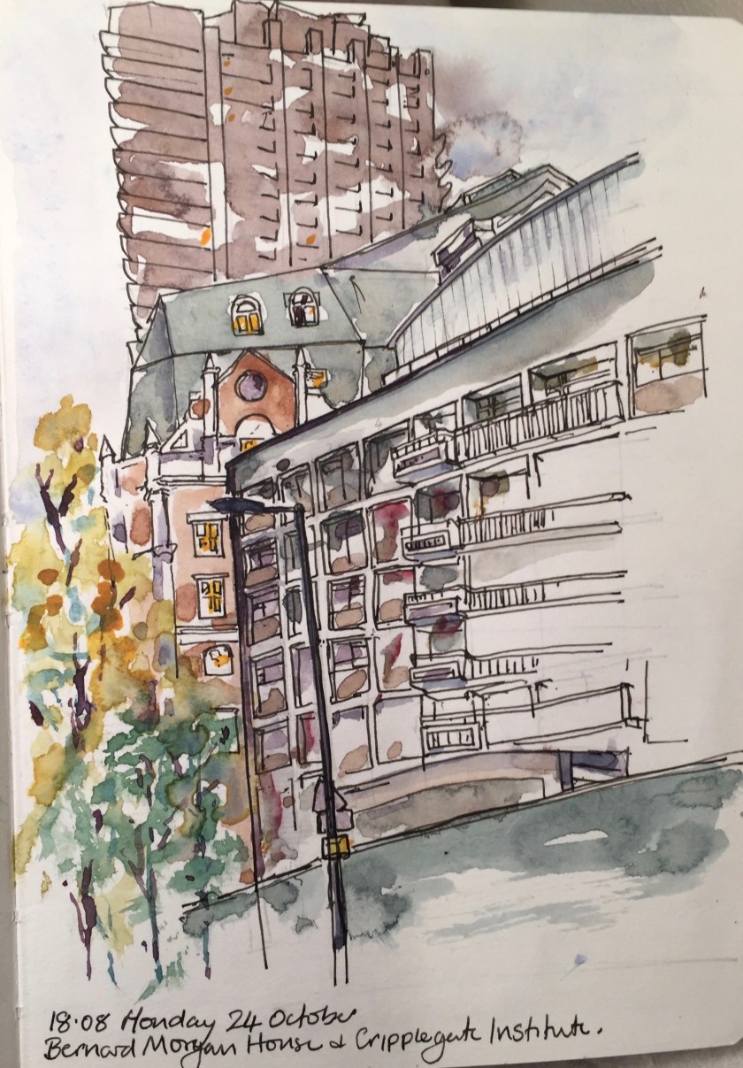
The building which was Bernard Morgan House has now been pulled down. This is sad. It had a calm 1960s look, and ceramic tiles on the side.
I looked across the gap and could see the Welsh Church: Eglwys Jewin.
The church is the building with the green roofed turret and the long windows. It was founded around 1774. According to its website “capeljewin.org” in the 19th century it was “one of the most powerful and influential churches in the Calvanist Methodist tradition”. It was very well attended in the 19th century so they built a new and bigger chapel on Fann St in 1879. This was destroyed in the Blitz in 1940. The building I’ve drawn was built in 1960.
Lauderdale Tower is just visible, to the left of the picture, and Blake Tower is on the right. Ahead, behind the church, is Tudor Rose Court, a City of London building providing sheltered housing to people over 60: 16 leased, and 60 social rented flats.
Bernard Morgan House used to be a City of London building too. It was a police house.
I drew it in 2016:
24 October 2016 – Bernard Morgan House and the Cripplegate institute.25 August 2016 – From Brackley Street: the Welsh Church and Great Arthur House (Golden Lane Estate) showing the wall of Bernard Morgan House
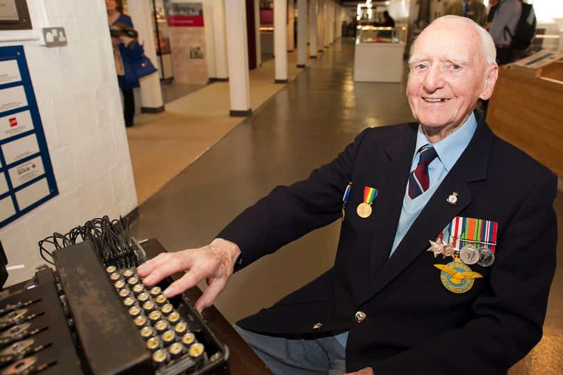
Who was Bernard Morgan? There is a Bernard Morgan, born in 1924, who was a code breaker in the Second World War. Was it him?*
Sgt (Retd) Bernard Morgan, an RAF D-Day code and cipher veteran, looking at a Type X machine (Manchester Evening News, 12 April 2014)
Taylor Wimpey are going to build luxury flats: “The Denizen”. This is how the view I’ve drawn will look after “The Denizen” is built:
“Street view” from the Taylor Wimpey website
Here’s another view of “The Denizen” from the Taylor Wimpey website. See how big it is! Fortune Park is the trees in the foreground. You can see Blake Tower on the right and Lauderdale Tower in the Centre.
The Denizen (centre), from the Taylor Wimpey Website
*Bernard Morgan Update, March 2018: John Tomlinson tells me that Bernard Morgan House was named for a councilman. Buildings and streets in the City of London are only named after people who died at least 20 years previously, and Bernard Morgan the codebreaker was evidently fit and healthy in 2014.
Click a button below to share this post online, email it, or print it:
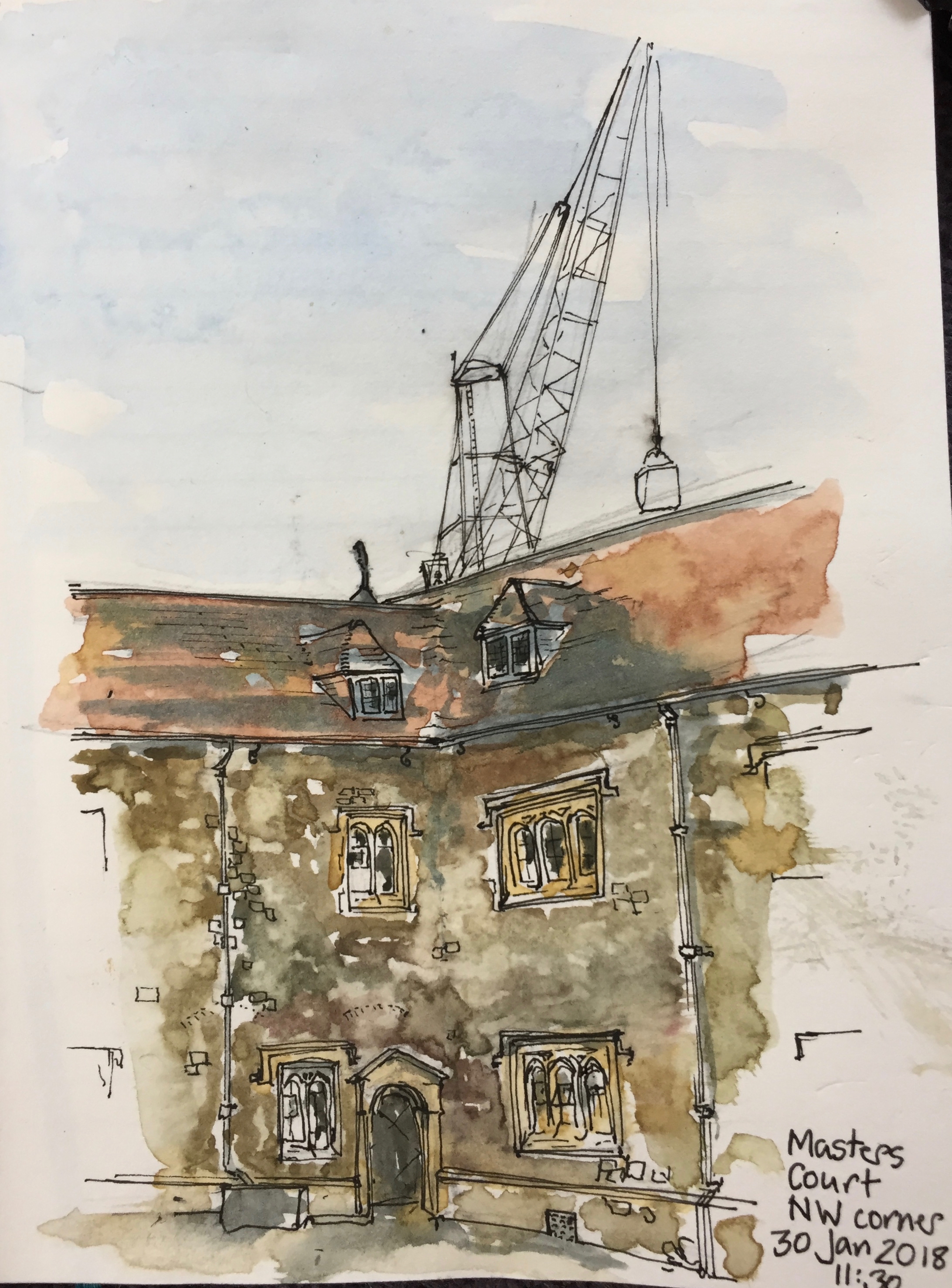
This morning I was again sketching in The Charterhouse. I’ve wanted to sketch in Masters Court, which has a fine façade on the Great Hall. But when I got there I preferred this view of the dark North West corner. Also there was a convenient seat.
I thought this view would be simple, but it wasn’t. The angle of those two roofs was a challenge.
While I was drawing, Mark came to mend the paving. He removed a heavy section of stone, and reset it. He looked at what I was doing. I asked him whether I should put in the crane, which loomed above the roof, and whose motor was clearly audible in the quiet courtyard. “Well,” said Mark, “it’s there!”
So I put the crane in. Then I met Robin, who asked if I would put in the crane driver, who was also visible at that point. So yes, the crane driver is in there too.
Here’s the picture:
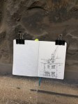
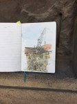
Here are some pictures of the painting in the location. You can see the colour of the stone. Also there is the picture in pen and ink before the colour went on.
Pen and ink
on the Charterhouse stones
Watercolour kit
1hour45minutes, drawn and coloured on location. Very cold (6 degrees C), but dry.
Click a button below to share this post online, email it, or print it:
I have previously drawn the Cheesegrater from Threadneedle Street. Today I went to find a good view from the East. I was keen to include the ancient church of St Katharine Cree.
Here is the Cheesegrater from Leadenhall, just east of Creechurch Lane.
The current building of St Katharine Cree is 1633. The tower that I’ve drawn is from 1504. Parts of the church date back to the Mediaeval Priory 1108. This place is a survivor. It survived
the Great Fire 1666
The Second World War, which damaged the roof
the Baltic Exchange bomb, 1992, which blew out the central part of the 17th Century East window.
The Cheesegrater, aka The Leadenhall Building, 122 Leadenhall St, was finished in July 2014. The architects were Rogers Stirk Harbour + Partners.
Behind, you can just see the cranes for 22 Bishopsgate under construction.
Drawn standing in the street, 1 hour, drawn and coloured on location.
Click a button below to share this post online, email it, or print it:
As the daylight faded, I made this sketch from outside 37 St Giles, Estagun House.
St Giles is the name of the road going North out of Oxford, and also of the Church, which where the road starts. There has been a “St Giles” church near Oxford from at least 1120.
“St Giles is supposed to have protected a wounded deer from hunters, and images of him usually show him accompanied by a deer pierced by an arrow. Many churches dedicated to St Giles are situated just outside city limits, where they could minister particularly to those who resembled the wounded deer – the weak and defenceless, such as lepers and beggars, who might not be welcomed into the city. Today, the St Giles congregation continues this tradition by working with the homeless.” [St Giles Church website]
The building is from 1200, the lower part of the tower in the drawing is 13th century. The top was altered in the 15th century.
Behind the tower, you see a crane, which is building part of Somerville College.
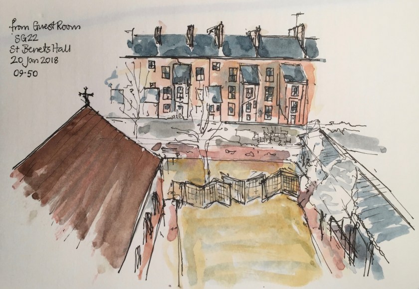
I was staying in St Benets Hall, 38 St Giles. Here is the view from the window.
Click a button below to share this post online, email it, or print it:
A very cold and blustery day.
Drawn from Ironmonger Passage, beside St Luke’s Gardens. My watercolour bag blew onto the ground, and the street sweeper, speaking Polish into his mobile phone, swept it up amongst the leaves. I raced after him to retrieve it, and he was very polite and apologetic.
“Gambier House was constructed in 1968 and is a 20 storey tower block, comprising 115 flats. The block is located on a triangular site between Mora Street and Lever Street. A small park is immediately adjacent to the south whilst surrounding properties, of between two and seven storeys, are in both commercial and residential uses. “
Gambier House was subject of a Planning Application in 2014, to install cladding. The above is an extract from this Planning Application. Here is a link to the document:
On the way back from the dentist, I looked up and saw The Cheesegrater, above Victorian buildings on Threadneedle Street. I sheltered from the rain under a Classical pediment, and made this sketch.
The Cheesegrater is also known as “The Leadenhall Building”, which is descriptive of its location, but not its shape.
22 Bishopsgate, Digital Information Point
The building to its left, under construction, is “22 Bishopsgate”. According to the informative panel from its builders, Multiplex, this will be 278m tall, with 3 basement layers, and 62 upper storeys, providing 1.4M sq feet of “net useable space” which accommodates 11000 people. That’s 1273 sq ft of useable space per person, or 141 sq yards: a space about 12×12 yards, which is about the size of our living room, including the kitchen.
I did the picture outside a building whose architects had had their names inscribed in serif capitals, low down: Mewes and Davis. This is number 53 Threadneedle Street, and now houses Montanero Asset Management Limited, and the Burger and Lobster Bar. A blue plaque of the City of London declares that this was the “site of the 13th Century Hospital of St Anthony, and of the French Protestant Church demolished 1840”.
Opposite, above a grand entrance door to number 30, is the motto “Concordia parvae res crescent” and the crest of the Worshipful Company of Merchant Taylors. This is the Merchant Taylors Hall, the yellowish building on the front right of the drawing.
“Concord will make small things flourish”
Multiplex also have “2 other projects on Bishopsgate”, said their notice, “number 15 and number 100”. I don’t know about making small things flourish, but big things are certainly flourishing.
About 45 minutes, pen and wash on location, drawn standing up.
Click a button below to share this post online, email it, or print it: