Absinthe Table: chine collé prints

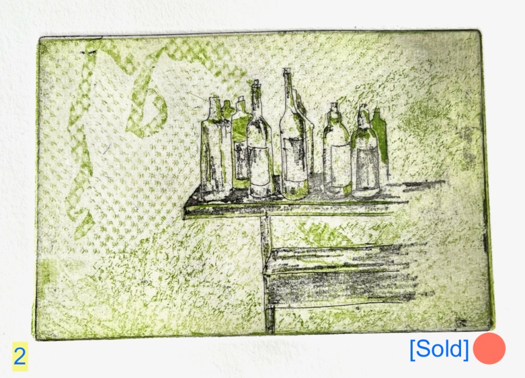
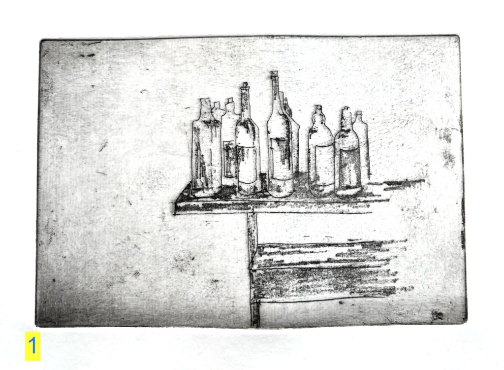
I made a new series of six prints of The Absinthe Table.

Print 1: single plate, black ink

I used black ink and green ink.

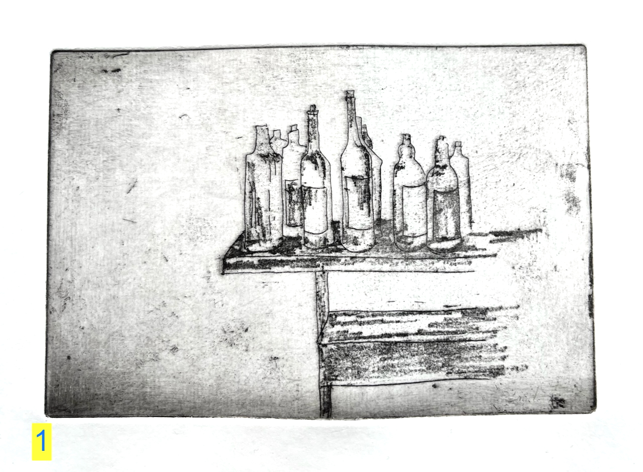
The ink is Intaglio Printmaker etching ink: Bone Black Shop Mix, and Light Green. Print 3 is made from two etched copper plates: first I printed the background pattern using green ink, then I printed the bottles and table, using black ink on another plate.

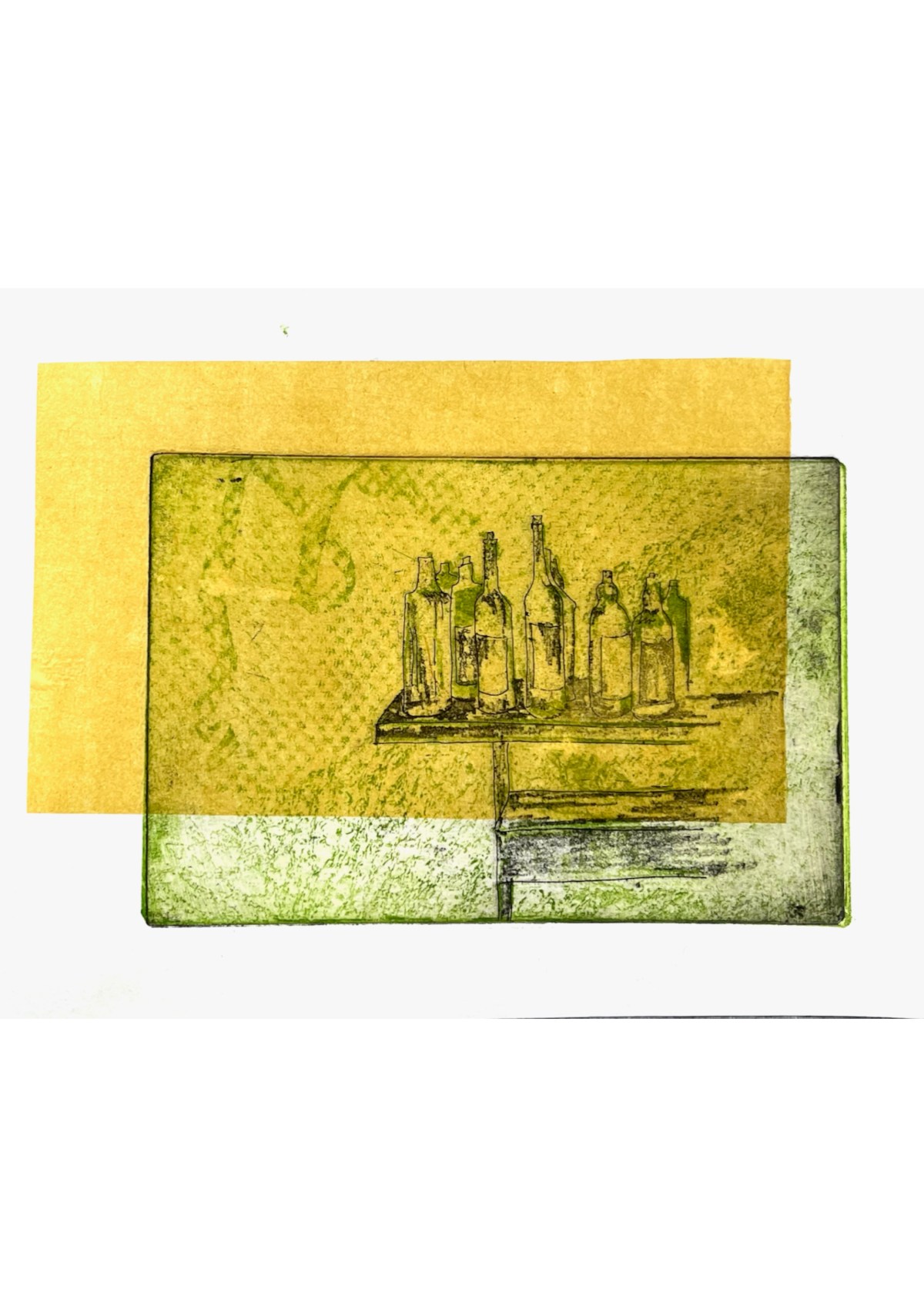
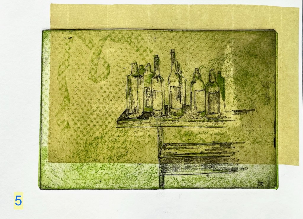
Then I made some more prints adding chine collé. Here are prints 5 and 6.

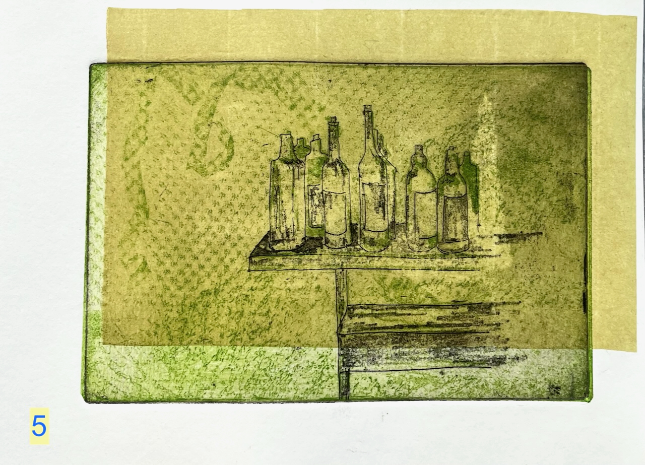
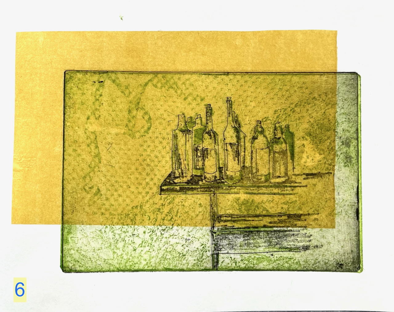
Chine collé is thin paper. I put it on the plate before the print roller goes over. The heavy rollers squeeze the coloured paper onto the picture, giving the yellow rectangles on the images of prints 5 and 6. The yellow rectangles give a sense of depth – maybe you are looking at these bottles through a window. Or maybe there is a window above casting a sunlit patch.

Prints 5 and 6 are made using two plates and chine collé. The process is lengthy and fraught with potential error:

  • put the glue on the yellow chine collé paper. Let it dry.
  • ink the green plate, the background
  • ink the black plate, the foreground. (don’t get them the wrong way round)
  • put the green plate on the press, inked side up (not inked side down)
  • put the white paper on top of it (don’t get ink smudges on the white paper)
  • roll the press across the plate, and keep the end of the paper under the roller so it doesn’t move while you….
  • …remove the green plate, and replace it with the black plate (get it oriented exactly where the green plate was, and the right way up, and the right way round)
  • put the glued chine collé paper on the black plate, glue side up (it is very lightweight and drifts about when someone walks past)
  • let the white print paper fall on top (as it falls it wants to dislodge the layers underneath)
  • roll the print press
  • remove the finished print ( examine – did it work?)

The chine collé technique is described on this page of my website.

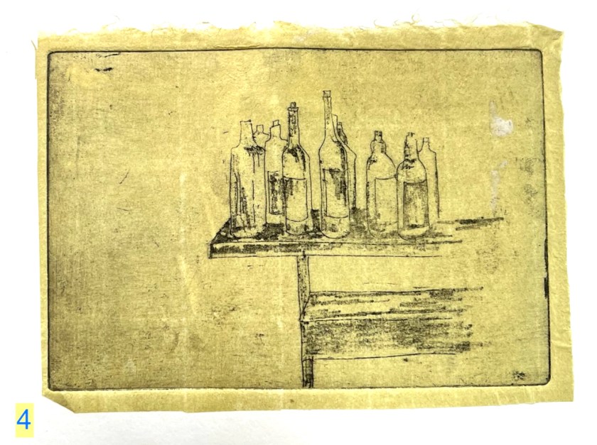
It is also possible to use the chine collé to provide a background for the whole image. Here is print 4. This is made using chine collé and one plate.

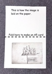
All these prints are made using heavyweight Fabriano Unica printing paper. It can be folded in half to make an A5 card to send to the absinthe enthusiast or wine drinker in your life. Or you can cut it down and frame it to make a small picture for your kitchen. The image itself is about postcard size: 10cm x 15cm. Let me know if you would like one? £25 + postage.

Here is a gallery of all six prints from this second series. These are all handmade prints from the etching press – not digital prints. I’ve numbered the prints in this post for easy reference. The numbers do not appear on the print you will receive. I can sign them if you like or not if you prefer them blank.

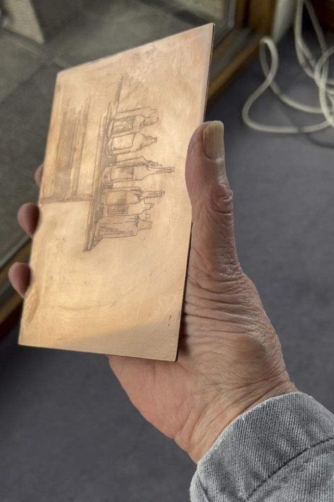
Here’s the copper plate I used for the black foreground:

Abbey Mills E15: sewage pumping station

Here is Abbey Mills Pumping Station, seen from The Greenway.

Abbey Mills Pumping Station, London E15, sketched from The Greenway, January 2025 in Sketchbook 15

Abbey Mills is a sewage pumping station1. It lifts the sewage from lower level sewers, and pumps it 40 feet uphill to the Northern Outfall Sewer. The Greenway path is on top of the Northern Outfall Sewer.

This system was created by the visionary Victorian engineer Joseph Bazalgette (1819 – 1891). The pumping stations and the Northern Outfall Sewer are part of a grand construction of sewers and water management works instigated in the 1860s after the “Great Stink” of 1858. The problem of untreated sewerage being discharged into the Thames had been causing disease and bad smells for some time. When the smell and fear of disease affected Parliament, which is located next to the Thames, the government of the day took action.

“On 15 June Disraeli tabled the Metropolis Local Management Amendment Bill, a proposed amendment to the 1855 Act; in the opening debate he called the Thames “a Stygian pool, reeking with ineffable and intolerable horrors”. The Bill put the responsibility to clear up the Thames on the MBW [Metropolitan Board of Works], and stated that “as far as may be possible” the sewerage outlets should not be within the boundaries of London; it also allowed the Board to borrow £3 million, which was to be repaid from a three-penny levy on all London households for the next forty years.”

https://en.wikipedia.org/wiki/Great_Stink

So this loan, and the 3d levy on Londoners was used in 1865 to construct the pumping stations and a new sewerage system.

The Victorian sewers are still in use, and are now gradually being upgraded by Thames Water.2 According to the video on their site, the Northern Outfall Sewer constructed by Bazalgette’s team is being left in place. Thames Water are pushing a lining into it, made of 21st century materials. They reckon this will last another 100 years. 3

I sketched Abbey Mills Pumping Station while exploring the Greenway from Hackney Wick to Becton.

“Thank you Sadiq”

The Greenway is a well-used pathway and running route. While I was sketching, a wiry grey-haired runner stopped to chat. He was a cheerful person, sharing my enthusiasm for the transformation of Hackney Wick. He had much praise for the improvements in London, specifically on air quality. Air quality is much better, he said. “I no longer get asthma,” he told me, “even though I still run!” He surveyed the clean path and the view, ” Thank you Sadiq!” he exclaimed. Sadiq Khan is the Mayor of London, and has introduced and supported air quality improvement measures such as the congestion charge and the Ultra-Low Emission Zone (ULEZ).

My new friend had been a skip-truck driver. He’d worked everywhere, he told me. Constructing the Olympic Park had been a big job. Examining my sketchbook, he saw the sketch of Fournier Street. “I recognise that!” he said. And then, looking closer, “There’s an Express Dairy depot just up the street.”

If you know Fournier Street, you will know that this seems extremely unlikely. Fournier Street is in a residential area, somewhat densely packed, and apparently not a place for a goods yard of any type. However he seemed sure, and I didn’t contradict him. I thought he might have mistaken the location: there are a lot of Georgian terraces in London.

35 Fournier St (1948)

When I was back at my desk I did a search4. Sure enough, just a few houses along from my sketch, there had been an Express Dairy Depot, just as he said. It’s shown in the “history” section of the Express Dairy site. The London Picture Archive shows it. I should not have doubted him. The wide entrance is still there.

I completed the ink sketch on location and then packed up to continue my walk. I still had a good 3 miles to go and it was getting dark, and cold.

It was dark when I reached Beckton. I left the Greenway as it crossed the A13.

Greenway to Beckton DLR. Map (c) OpenStreetMap contributors.

If you’d like to follow my route along the Greenway, in the file below is my idiosyncratic description of the route and my walk. The below file is 6 pages printable pdf. The Greenway is part of the Capital Ring, a long-distance walking route.

  1. Abbey Mills is a working Pumping station and not open to individual visitors. It is open to groups from time to time. The organisation “Subterranea Britannica” was invited for such a visit in 2012, which they wrote up in their journal Subterranea, Issue 30. The article describing their visit is by Martin Williams and Alex Lomas. See this link:
    https://www.subbrit.org.uk/sites/abbey-mills-pumping-station/
    ↩︎
  2. Major £70million upgrade to Stratford’s Victorian sewer system
    Press release from Thames Water: Tuesday 17 January 2023 13:09.
    https://www.thameswater.co.uk/news/70million-stratford-sewer-upgrade
    “A giant Victorian sewer in East London is being upgraded as Thames Water continues its investment in infrastructure across the capital. 
    The UK’s largest water and wastewater company is investing £70million over the next three years to upgrade the Northern Outfall Sewer and ensure its pipes are resilient for future generations. 
    The sewer, which serves over 4 million people, runs from Wick Lane to Beckton Sewage treatment works, the largest in Europe.   ….”

    ↩︎
  3. YouTube video “on Tap” from Thames Water, describes the work being done in 2023 to upgrade the Northern Outfall Sewer. It also contains great photos of the inside of Abbey Mills Pumping Station, and amazing aerial views of the Greenway.
    https://youtu.be/d628Y0dh2sA ↩︎
  4. The Express Dairy depot in Fournier Street is shown in a photo on the Express Dairy site.
    https://expressdairytales.uk/ed-retail-london-and-south-1974-and-before
    1948 Express Dairy depot at 33-35 Fournier Street. Photo by Paul Simm.
    and
    London Picture Archive
    https://www.londonpicturearchive.org.uk/view-item?i=121843&WINID=1735932557537
    1955 view of the same premises. ↩︎

North side of Broadgate Circle, EC2M

Broadgate Circle is undergoing massive redevelopment. Here is the view looking North.

View of the North side of Broadgate Circus, 2 Finsbury Avenue under construction.
Sketched, 30 December 2024 in sketchbook 15.

The concrete cores in the background are 2 Finsbury Avenue under construction. The previous building was demolished. On the left is 1-2 Broadgate, replacing previous buildings. The steel-clad building on the right is 5 Broadgate which replaced 4 and 6 Broadgate and sealed up the access road that led between them.

Building replacement: after 40 years, all change.

Broadgate Circle was constructed in 1985-7 on the site of the former Broad Street station. Here is what the 1980s buildings looked like:

4 and 6 Broadgate, on the North side of Broadgate Circle, before 2012.
From: https://knowyourlondon.wordpress.com/2015/09/14/broadgate-circle/

5 Broadgate, on the right of my sketch, replaced the two buildings in the photo above. It is occupied by the bank UBS. The building has its own Wikipedia page:

The two lowest storeys contain a 200-seat auditorium, restaurants, a gym, and a dry cleaner. Above those are four trading floors which can fit 3,000 people each, as well as seven storeys of offices above. The superstructure is divided into a grid of 13.5-by-12-metre (44 by 39 ft) sections, arranged around the trading floors. Three of the building’s four utility cores are placed along the site perimeter to increase the amount of space on each trading floor.

Wikipedia – https://en.wikipedia.org/wiki/5_Broadgate

The new 2 Finsbury Avenue “consists of a 12-storey podium with a 21-storey West Tower and 36-storey East Tower.”1 It is due to be completed in 20272 and will look like this:

The new 2 Finsbury Avenue, from the website of the architects 3XN.
For scale: 5 Broadgate Circle is on the right of this picture, with the >< signs on the side.

Broadgate Circle is owned as a joint venture between British Land and GIC3. It is adjacent to Liverpool Street Station on the East side of the City of London.

Sketch map showing the location of Broadgate Circle, and my viewing line for the sketch

Here are photos while I was sketching:

Here are links to more views of the 1980s buildings:

Sketchbook 15
  1. Pictures and descriptions of the new 2 Finsbury Avenue are from the architects’ website: https://3xn.com/project/2-finsbury-avenue-broadgate ↩︎
  2. 18 April 2024 Press release from British Land and GIC. See the press release on this link, file attached below in case the link has expired. https://www.britishland.com/news/broadgate-secures-landmark-pre-let-at-2-finsbury-avenue/ ↩︎
  3. British Land is a UK property developer and GIC is “a leading global investment firm established in 1981 to secure Singapore’s financial future”. GIC is “the manager of Singapore’s foreign reserves” Quotes are from press release below. ↩︎

25 Fournier Street, London E1

Fournier Street is a row of 18th century houses in Spitalfields, east London. Here is number 25.

25 Fournier Street, sketched 19th December 2024 in sketchbook 15

The weather was cold, and I was sheltering from the wind in a doorway opposite.

People rushed past on the pavement in front of me. It was nearing Christmas. I caught fragments of conversation. “Everyone’s after money” said a woman to her companion, “and it’s wrong!“.

I enjoyed spending time looking at this elegant house. The tops of the windows are curved. This is quite common in London. What is unusual here is that the wooden window frames are also curved, and the top panes of glass are curved to match. This must make replacing the glass quite a labour, I thought, and the curved sash window frames would need a skilled carpenter.

A woman approached, looking bothered. She caught sight of me in my doorway. I thought she wanted to open the door where I was standing, to enter the house behind me. So I was ready to express my apologies and move my stuff out of the way. But no, she wanted directions to Brick Lane, which is at the end of Fournier Street. “Just there,” I said, pointing. Brick Lane was almost visible, in a straight line from where we were standing.

She was flustered and didn’t seem quite to believe my simple direction. “It’s all changed round here!” she objected. I paused.

This street has hardly changed in 300 years. I’d just spent an hour looking at a house that was built in 1727. But I didn’t say that: a latent voice episode1.

She was an artist too, she told me. She was looking for a gallery. She hurried off, in the direction I’d indicated.

I was left looking at the house, and thinking.

  1. latent voice episodes = “potential communications that may or may not in fact occur”, Harvard Business School paper: Working Knowledge, Q&A with Amy C. Edmondson, author: Sarah Jane Gilbert, March 20, 2006. “Latent voice episodes” is a useful concept, I think. It’s for those times when you might speak, but don’t. ↩︎

Chichester Cathedral

Here is a view of the south transept of Chichester Cathedral.

Chichester Cathedral, South transept, sketched 5th December 2024 from Canon Lane, in Sketchbook 15.

The first spire was built around 1500. There are no bells in the spire: the medieval builders put the bells in a separate little building in the cathedral grounds. This was just as well. The spire collapsed in 18611. It was rebuilt to the designs of Sir George Gilbert Scott, and that’s the spire in my drawing.

Chichester: location
Sketchbook 15

George Gilbert Scott was a prolific 19th century architect. I have sketched his work before:

Chichester Cathedral

Here is a view of the south transept of Chichester Cathedral. The first spire was built around 1500. There are no bells in the spire: the medieval builders put the…

Waterpoint, St Pancras, London N1

This structure is visible from the North side of the Regents Canal at Coal Drops yard. It was a “water point” for replenishing the boilers of steam engines. The top…

St Mary Stoke Newington N16

“What is that spire?” It’s just visible, on the horizon between office blocks. Some work with the binoculars and the map established that it must be St Mary Stoke Newington,…

  1. This history of the cathedral is on their website:
    https://www.chichestercathedral.org.uk/about-us/little-history-cathedral
    ↩︎

New Year 2025

Happy New Year!

This is a woodcut, based on the rooftops of the town of Rye, in East Sussex.

inking the wood block

Bedroom becomes print studio.

Many good wishes for 2025!

Greetings!
Glad, as the years pass,
that I am granted
another evening
.

The Market Café, Broadway Market, E8

Here is the Market Café, which is at the South end of Broadway Market, near the canal.

Market Café, Broadway Market, Hackney E8, sketched 12 November 2024, 12″ x 9″ [sold]

I’ve sketched the Market Café before, and written about it on this post. This latest sketch was a commission to celebrate a happy event which took place there.

Here are some details from the sketch:

It was a bright and cold day. I did the pen and ink on location.

The photographer Nick Hillier came by and took some photographs of me working, which he kindly sent me later.

Sketching on location, image credit: Nick Hillier. Pen is a Lamy Safari.

I added the colours at my desk. The colours are:

  • for the brickwork: Fired Gold Ochre
  • all the greys and blacks are: Ultramarine Blue plus Burnt Umber
  • the sky is Phthalo Blue Turquoise
  • the green tiles are Serpentine Genuine
  • there’s a bit of Permanent Yellow Deep on some of the highlights and some dots of Transparent Pyrrol Orange
  • the fine white lines are made by using a rubber resist gum. I use Pebeo drawing gum.

For my current palette see this link. I have 12 colours in my palette. For most pictures I fewer colours. This picture used about 7 colours.

Thank you to my client H for the commission and for allowing me to post this image here.

I’ve sketched around the Broadway Market area before. See this link for a sketch of Climpson Coffee, and here is a sketch done at E5 bakery on the other side of London Fields.

Sketch location

North entrance to the Woolwich Foot Tunnel, E16

The North entrance to the Woolwich foot tunnel stands isolated on a traffic island.

North entrance to the Woolwich Foot Tunnel, sketched 26th November 2024 in Sketchbook 15

The Woolwich Foot Tunnel opened in 1912, and is still open today, 24 hours a day. It connects the North and South sides of the River Thames.

I walked through the tunnel on an adventure exploring Docklands, inspired (once again!) by a fascinating article on the “London Inheritance” site.

My expedition started at London Bridge pier, with a trip down the Thames on the riverboat. This seemed the simplest way to get to the docks. It takes about 50 minutes to go from London Bridge to Woolwich.

The route of the riverboat from London Bridge to Woolwich.

Everyone gets out at Greenwich, but it’s well worth going a bit further. The boat is empty, the Thames is huge, and the sky opens out.

The City of London seen in the distance, from the Woolwich Royal Arsenal Pier

The river boat pier at Woolwich is on the South side of the river. I was keen to explore the North side, so I walked a little way to find the entrance to the foot tunnel. There is also a ferry, but I wanted to experience the foot tunnel.

The South entrance to the foot tunnel is hard to find. It’s crammed into a dark space behind the leisure centre. It looks somewhat dingy and derelict.

South entrance of the Woolwich Foot tunnel, hemmed in by 1970s buildings.

You have the option of the lift or the stairs. I followed the arrow to the stairs. The stairs are round the back. You have to find your way in, sidling between the wall of the leisure centre and the columned entrance to the tunnel. I can’t help feeling that the constructors of the tunnel would be appalled that their ornate entrance had been obstructed in this way.

Entrance to the stairs, under the canopy. Leisure Centre is the blue part on the left.

By this time I was rather doubting the wisdom of this undertaking, as the old building seemed so abandoned, and the entrance was so dark. However, the stairs were brightly lit, and it all seemed feasible. So down I went.

The tunnel itself is marvellous: all bright and clean, with amazing acoustics. I could hear the distant voices of people ahead of me.

Inside the Woolwich Foot Tunnel

On the North side there is a different world. The North entrance, unlike its Southern counterpart, stands proud and isolated on an expanse of concrete. I sat down and sketched it.

The building stands on a traffic island which is a junction of many routes. The A117 takes heavy traffic onto the pier, to load onto the Woolwich Ferry. There’s a bus, the Superloop SL2 ,which goes to Walthamstow. People walk from the bus to the foot tunnel.

North entrance to the foot tunnel. The Superloop bus from Walthamstow is in the background.

The signpost on the left of my drawing indicates the long distance footpath “The Capital Ring”. I followed this route along the Thames a little way. The path is cut off after the Galleons Point Housing development. Signs say that the lock gates are being maintained. So the route returns to the main road and passes over the spectacular bridges across the docks.

The bridges offer a view directly down the runway of London City Airport. When I walked past, some boys were enthusiastically photographing the aircraft on their mobile phones.

Plane spotters on the bridge over the Royal Albert Dock. City of London in the distance.

The other direction from the airport, looking toward the Thames, is a scene which seems to define what we mean by “brown field site”.

A brown field site: Albert Island, North Woolwich. This photo was taken from the same spot as the one above, but looking the other way.

In the distance on the left, you see the housing developments round Gallions Reach. The quantity of space round here is astounding. And the docks are enormous.

Royal Albert Dock from the Steve Redgrave Bridge. The dock is about a mile long. The University of East London is on the right, City Airport on the left, City of London towers in the distance.

I walked on over these immense bridges over the docks. An oncoming bus tooted cheerfully. I looked up to see the driver smiling a friendly greeting. Perhaps I looked a little lonely and cold. The bus rushed on. I felt warmer.

On the other side of the bridge I warmed up in the “Wild Bean Café” (recommended) and then made my way to Gallions Reach DLR station and thence to central London.

If in need of wide open spaces and a bit of distance from the problems of the City, then a trip downriver is definitely the thing.

Nyon, view from the castle

Standing on the ramparts of the castle at Nyon, I look towards Lake Geneva.

Rooftops from Nyon Castle, 29 October 2024 in Sketchbook 15

The tower in the picture is at the junction of Rue de Rive and Passage des Pirates, Place Abraham HERMANJAT 1862-1932. I can find its position on a map, but it is unremarked and seems not to have a name. If there is any citizen of Nyon out there who can identify it, I’d be very grateful.

Lake Geneva is in mist, in the background of the picture. The mist came and went as I was sketching. It was extremely cold.

Map from Nyon tourist office, showing the sightline of the drawing.

Nyon is easy to navigate because it is on a slope, from the train station at the top of the map down to Lake Geneva at the bottom of the map.

The map above came from the Nyon Tourist Office who also offered a leaflet reminding me that part of the action in the Tintin book “L’Affaire Tournesol” took place in Nyon. This book is called “The Calculus Affair” in English. On page 21, you can see the the white car which takes Tintin and Haddock along the lake. It has Vaud number plates (“VD”).1 The fire engine which rescues them from the ruins of the house on page 27 is, according to the tourist office, carefully preserved in a local museum.

I read the Tintin books assiduously as a child, and again, in French, years later. I think the pictures influenced my drawing style, and may be why I like to draw in pen and wash today. So as well as being a record of a moment spent on the freezing battlements of Nyon Castle, the drawing above is my small homage to the great Hergé.

Sketchbook 15, with items from the leaflet “Tintin in Nyon”, and a leaf.
  1. The images from the Tintin books are protected by copyright, so I am not including them here. But do have a look if you have a copy of the book at home. ↩︎

Climpson & Sons – Broadway Market E8

Here is a sketch of the coffee merchant Climpson & Sons, on Broadway Market in Hackney.

Climpson & Sons, 67 Broadway Market, London E8, sketched 22 October 2024 in Sketchbook 15

I was sitting at a table in the café opposite, which is called “Route”.

Climpsons are a coffee merchant and roastery based in East London. They roast their coffee in Walthamstow, and their HQ is just the other side of London Fields from Broadway Market.

They were doing a brisk trade as I sketched, and people drank their coffees on the benches outside.

I did most of the sketch on location and finished it at my desk.

Sketchbook 15