Paul Street, Shoreditch

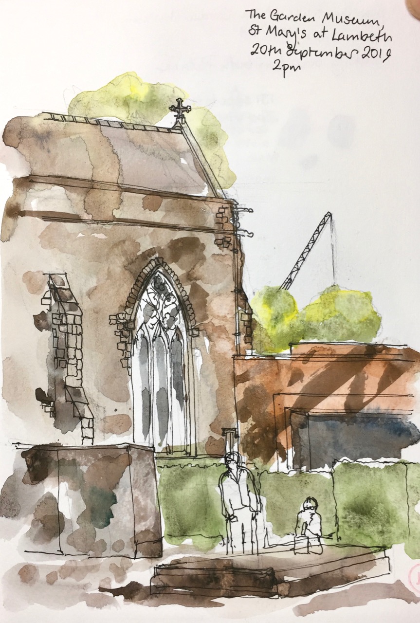
Shoreditch, in East London, is a mix of a place. In this view you see many of the constituents of the mix. IMG_3731

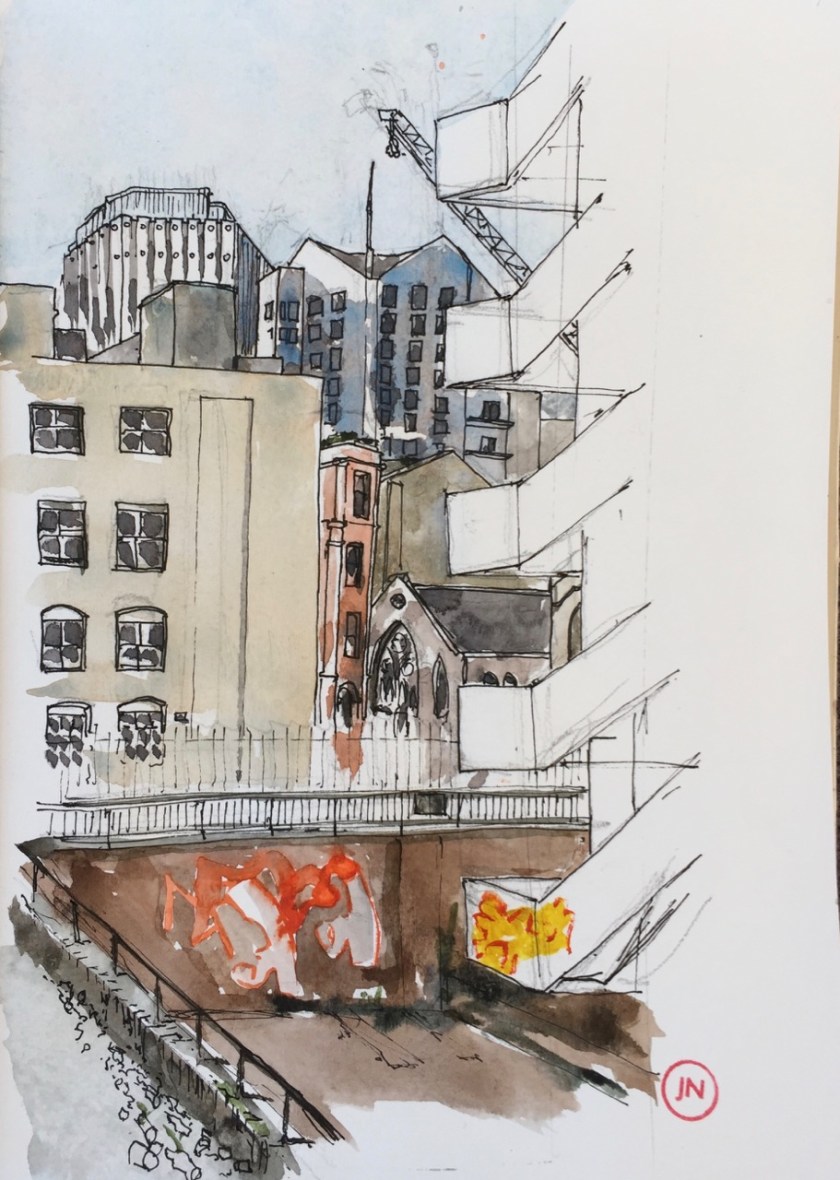
The staircase on the right is “Development House” 56-64 Leonard St. It is boarded up, and adorned with graffiti. It is not, however, empty. I saw several sets of people descend the stairs while I was drawing. It was not at all obvious what they were doing there. I could not tell if they were residents, security guards, architects, property investment professionals or graffiti artists.

There is an unremarked and very lovely statue on the side of Development House. It shows people helping each other climb a steep staircase. I can find out nothing about it. It’s an inspiring image. I hope it doesn’t get scrapped when the site is re-developed.*

The glorious brick wall on the left of the drawing is the back of a warehouse at 62/72 Tabernacle Street. It looks as though it might still be a warehouse, since the signboard at the front says “EMA Textiles”, and cardboard boxes are stacked behind the windows. Next to it, further left out of the picture, is 52-60 Tabernacle Street, which is also a warehouse, but that one has been renovated and all the brick is marvellously repointed and neat: “warehouse space to lease” says the notice.

The red brick building is on the opposite side of Tabernacle Street. It is “McQueen” which is a night club and bar. The gap between Development House and the nightclub is what looks like an old bomb site. It is now a car park, and is a sunken area, with remnants of walls, and buddlia bushes. It all looks rather provisional, but it’s been like that for years. Sometimes there is a dance venue in the sunken area. I’ve drawn in this area before. See this post:  Shoreditch skyline

The modern buildings in the background are “White Collar Factory” on the left, a multiple occupancy office space, and the Bezier Building on the right, with the flagpole or antenna. It doesn’t look like a flagpole.

The ecclesiastical building in the centre is part of the Central Foundation Boys School, a state school.

I drew this picture standing up overlooking the litter strewn area by Development House. While I was drawing, a horn bleeped. A car drew up, running its engine. The bleep had come from a motorbike behind the car. I saw to my astonishment that the back of the car was connected to the motorbike by a strap. The car was trying to tow the motorbike. This was obviously not working out well. They had stopped to reconsider. The motorcyclist dismounted and removed his helmet. Manoeuvring followed. I returned to my drawing. They tried this twice more before giving up.

When I’d finished the pen and ink I crossed the road to a little restaurant with wooden slatted tables outside. I gestured to the table, and smiled at two people of asian appearance behind the window.  They nodded and smiled and continued their dialogue with the mobile phone screen. I sat down and got out my watercolours. Before long, a smiling person appeared and asked what I wanted. I said tea. She said “Bubble tea?”. I did not know bubble tea. It was 4pm and I am English so I said “ordinary tea”. This caused her to nod, smile and disappear. She came back with a menu. I pointed to the only tea I recognised, which was “oolong tea”. “With sugar?” she said. I smiled and said no thankyou. I went on with my painting.

What appeared at my table was not what I expected. I was expecting a teapot, or a mug. Steaming. Hot. Fragrant. With a spoon, perhaps. No. What appeared was a bottle. Chilled. “Oolong tea, no sugar,” announced the server, placing the bottle ceremoniously on the table.  She smiled. I smiled. She went back inside. I cautiously opened the bottle. It was indeed tea. Cold tea in a bottle. Not what I expected, but pleasant, and plentiful.

IMG_3730
Cold tea in a bottle.

The restaurant was “Buy and Bite: Popular Taiwanese Street Food”. A new experience for me. And only a short walk from home. The food looked really good. To try. Another time. Amazing London.


*Redevelopment of “Development House”

Online I found a planning application [Development House, 55-64 Leonard Street, London Borough of Hackney Local planning authority reference: 2017/4694] for demolition and rebuilding on this site, dated 2017. Here’s what the proposed building will look like:

001.png

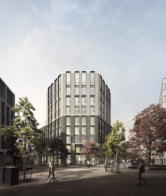
But since the website declares “completion in 2018” and it is now 2019, there may be a subsequent scheme. Here’s an extract from the Allford Hall Monaghan Morris website.

Allford Hall Monaghan Morris (architects)
Completion:2018
Melvale Holding Ltd with client representative Darmouth Capital
The proposal for the new Development House will replace the tired and almost empty existing building with a new 100,000sqft per nine storey building of office with A1 activities at ground floor that will activate the frontage along Leonard Street and Circus.

Melvale Holding Limited is a company incorporated in Jersey, with a registered office in Jersey which has an address in common with a large number of other registered companies: Equity Trust (Jersey) Limited.  “Melvale Group”, which may well be related, describes itself as ” a diversified management, international trade, foreign direct investment and financial advisory consulting organisation and we work for both the Private and Public enterprises and institutions.”. But I am no further on. This Melvale Group has an address in Cobham in Surrey.

Dartmouth (not Darmouth) Capital is based in the City of London. They list “Development House” in their “portfolio”, and say about it, on their website:

The scheme prepared by local architect Waugh Thiselton is for an impressive new office development of circa 90,000 sq ft which will include ancillary retail space at ground floor level. The Shoreditch area is at the heart of the Technology, Media and Telecoms sector and enjoys demand for offices, particularly for unique buildings, and is a market with limited supply.

The scheme by Waugh Thiselton is quite different from the scheme above, and pre-dates it.  Here’s their 2016 proposal:
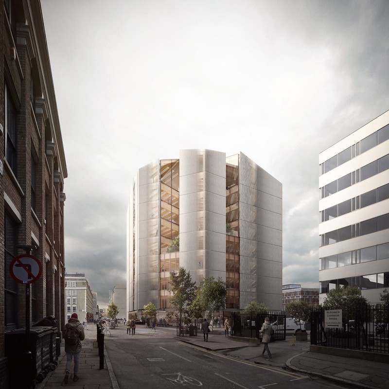
SS-1_551_REN_07.jpg.1200x800_q90.jpg

They say:

“This nine-storey timber-framed office block will be the tallest engineered timber building in London, and a beacon building for Shoreditch.”

They propose a whole lot of green and environmental ideas. But since the Allford Hall Monaghan Morris proposal is later, then that’s the one we’ll get, most likely. The street which goes back on the left of the building in their drawing is the one where I had my oolong tea, and did my drawing. None of these proposals say what is going to happen to the statue.

Garden Museum in Lambeth

I drew a picture waiting outside the Garden Museum in Lambeth.

IMG_3739

The Garden Museum is inside St Mary’s Church. The upmarket restaurant attached to the garden museum is the bronze-coloured cuboid on the right. The slab of stone which the tourist is sitting on is a tomb.

Prompted by an article in a newspaper, we were at the “Garden Museum” in Lambeth to see an exhibition of the art in Ladybird Books. I learned to read with Ladybird Books, as did so many others of my age. Here are pages from “Shopping With Mother”, one I remember with particular clarity. These are photos of the copy I still have, published 1958.

Note that Mother is wearing a hat and white gloves.

Since the exhibition was at the Garden Museum, they showed the art in the Ladybird Books of Trees, of Garden Flowers, and so on.

We also went up the tower of St Mary’s Church. It is 131 narrow steps. At the top it was very windy and we had a superb view. Here is what Lambeth Palace looks like from the tower.

IMG_3738

In Victoria Tower Gardens, next to the Houses of Parliament, there was a huge demonstration to draw attention to Climate Change. The loudspeakers from speeches at the demonstration were accompanied by car horns and swearing of angry drivers, caught in traffic jams in the surrounding roads, and the wails of sirens as ambulances tried to reach St Thomas’ Hospital which is nearby. It was a soundscape of competing interests.


Museum of the Order of St John – garden

I drew this in the Cloister Garden of the Museum of the Order of St John, Clerkenwell, a beautiful tranquil place on a hot day.

IMG_3677

It was a very hot day, and I’d left the flat in some irritation, after a series of frustrations, mostly computer-related. Then one of my favourite cafés charged me far too much for a coffee, and added service charge without telling me. So I went to the garden.

Because I’d left the flat in such haste, I’d forgotten to bring my water pot, which was going to be a problem. However by the time I’d done the pen sketch, the woman on the bench opposite had finished her lunch, and I was able to ask her for her empty drinks bottle. This she graciously gave me, commenting on how pleased she was that it was going to be re-used. If you are reading this, thank you.

Screen Shot 2019-09-16 at 18.07.26.png
The logo of the Order of St John

The modern Order of St John is a charitable foundation. They are behind the St John Ambulance. This latter organisation has the commendably clear strapline: “We Save Lives”. They do this by educating people in first aid, and providing highly trained volunteers at events and disasters.

The Cloister Garden is by the Priory Church.

Screen Shot 2019-09-16 at 18.05.55
Map credit: website of the Museum of the Order of St John.

From the Barbican Lakeside Terrace

This is a drawing on one of those hot days last week.

I sat at one of the tables on the Barbican Lakeside Terrace and drew what I saw. The massive building is 125 London Wall, a multi-occupancy monolith. Behind, to the right is 88 Wood Street, designed by Richard Rogers (“Rogers Stirk Harbour + Partners”). It’s a bit like the Lloyds Building, with transparent walls and lifts you can see going up and down. On the left is the new building at One London Wall Place.

In front of all that is the side of St Giles’ church, with its castellations. There was a celebration going on: Barbican@50.

IMG_3676

The banner you can see fastened to the railings says “SOSBarbican.com”. It is placed by objectors to the proposed extension of the Girls School.

1 hour 20.

Guildhall School of Music and Drama

Here is the Guildhall School of Music and Drama, seen from across the Barbican Lake. I drew this sitting on a ventilator grille in an alcove of the residential flats in Andrewes House.

IMG_3608

The Tower in the distance is Cromwell Tower. The sloping glass roof is the Barbican Conservatory. Gilbert House is the residential block on the left. In the foreground is the magical sunken garden, a planted area whose walkways are below the level of the lake.

IMG_3621
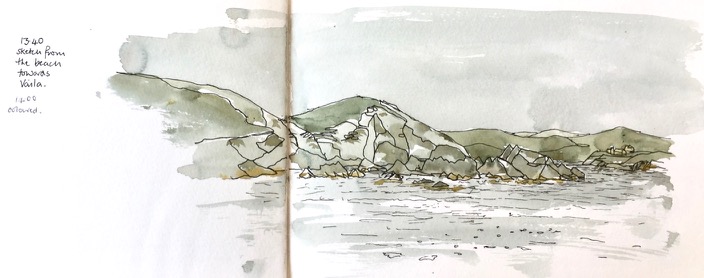
As I drew, I was watched with interest by mallard ducks. One settled at my feet, in a proprietorial way.

I had not noticed before that the Guildhall School is built as a series of blocks, rather like a container park. The top row and the bottom row don’t quite match. The second row has a series of upright concrete beams, which I’ve shown, between the blocks.

I saw that the windows are angled. The inhabitants of one block must be able to see, in a sideways sort of way, into the next block. I’ve never been inside the School, so I don’t know how this works out in practice. But after all, this is a school of performing arts, so it’s rather good if you can see your fellow students through a window: every window a stage.

However the angling of the windows meant that from outside I couldn’t see inside.  I have to wait until the performers are ready to present their pieces on a public stage. Still, from time to time I heard a flight of notes on a saxophone. Perhaps they had opened the window of one of the practice rooms.

About 2 hours, including a chat to a fellow resident who stopped by.

Predominantly just two colours: Perinone Orange and Prussian Blue, with a tiny bit of Mars Yellow in the rushes.


St Mary Abchurch

Here is St Mary Abchurch, a view from Cannon Street, London EC4. There was a church here from about 1198. It was destroyed by the Great Fire in 1666. The current church was built to the design of Christopher Wren in 1681-86. It is the headquarters of the “Friends of City Churches” who make the City Churches accessible.

This is one of those ephemeral views. There is a huge building site in front of the church, and so when the building is done, this view will disappear.

IMG_3598

The notices on the hoardings say:

“DANGER! No climbing. Fall behind”

“Dragados SA (UK) Considerate Contractor Scheme, 30th Anniversary Winner 2018”

“No Pedestrian Access or Egress Apart From Plant Movements or in an Emergency”

I enjoyed the use of “Egress”, and puzzled over the phrase “Fall behind”. It must mean “There is a big drop behind this notice”, but it sounds like “We are delayed, and falling behind schedule.”  There is also a huge Health and Safety notice, mandating in detail the protective clothing you must wear, including, rather ominously:

“Flame retardant clothing must be worn near buried services”

What’s this building? Well, according to the notice:

” We’re transforming Bank Station to improve your journey. Completion 2022. Search TFL Bank”

I searched “TfL Bank” as instructed, and found a vast amount of information. TfL (Transport for London) is making Bank Station bigger – a “capacity upgrade” as they term it. The building site I’ve spent this afternoon looking at is described thus:

“The Cannon Street worksite consists of the area bounded by King William Street, Nicholas Lane, Cannon Street and Abchurch Lane. The proposed new station entrance and infrastructure such as new escalators will be constructed on this site, which is currently occupied by six buildings. Demolition will be required to allow the worksite to be established before the start of any ground treatment, piling or work on the station entrance. The façade of 20 Abchurch Lane will be retained and will partially screen Abchurch Yard from the works. The worksite is over the proposed new Northern line platform tunnel. The site provides access to the work below ground through the new station entrance box and escalator barrel. During the works there will be site office and welfare facilities within 20 Abchurch Lane. The proposed worksite provides a minimum of space for storage of some materials and equipment for construction operations. It will also be used to store excavated material, before it is transported off site.”

They provide wonderful maps. Here’s an extract:

Screen Shot 2019-09-08 at 19.39.40.png
From “Bank Station Capacity Upgrade – fact sheet 2”

It’s somewhat reassuring to know they have such detailed maps, as the area round St Mary Abchurch looks medieval. I walked through there, down “Sherbourne Lane” and back home though the alleyways of the City.

Here’s my map, and some work-in-progress photos.

About two hours, drawn from the steps of 108 Cannon Street.


Barbican Lakeside Terrace from St Giles’

Here is a picture of someone looking across the Barbican Lake. Their mobile phone is telling them that the Barbican Arts Centre, the Lakeside Restaurant, the Art Gallery and the Cinemas are all over there in the sunlight. Such delights! But how do I get there? In between here and there is some murky water, and a big drop down.
What they need to do is to turn their back on where they want to go, walk, go up an obscure staircase that looks private, and then proceed across Gilbert Bridge which is high up to their right and invisible from where they are standing. I would have told them all this, but they obviously worked it all out for themselves before I could put my paintbrush down and descend from the tiled stone monument where I was sitting. Perhaps the mobile phone app is, by now, educated on the Barbican geography.

IMG_3544

The tower in the picture is Cromwell Tower, and the glass building is part of the Barbican Conservatory.

IMG_3537
“SOSBarbican.com” banner on Mountjoy House

Today there are banners outside some of the flats in Mountjoy House in the Barbican. They are there to draw attention to the proposal by the City of London School for Girls to build an extension, including kitchens, right underneath these flats. I have drawn pictures to illustrate the proposal, and to show why many of us object. See this link: Under Mountjoy House, Barbican

Information about the campaign is here: Objection  to CLSG expansion. If you appreciate the Barbican architecture, please consider signing the petition.

Here is a map:

IMG_3545
Map showing the direction of the view in the picture, and the location of the banners.

Sunday stroll in the City

From Fenchurch St Station there is a stunning architectural view. I sketched it, standing outside the station. This was not a great place to stand. I put the colour on later, sitting down in the wooden seats nearby. A woman with a bike came by and told me someone had let down both her tyres. Why would they do that, she asked me. Why indeed. She went off, pushing her bike on its flat tyres. Her dog followed on its lead, disgruntled,  catching the mood of its mistress, deprived of a ride in the special dog-basket on the back of the bike.

IMG_3518
From Fenchurch St Station, looking West, along London Road

Shown in the picture on the left is “Minster Court” a pinkish coloured Neo-gothic building built in 1991. It contains, amongst other things, the “London Underwriting Centre” and “Proud Cabaret City”, and a branch of “Balls Brothers”, a pub.

IMG_3520
Sketch map, showing the direction of the view from Fenchurch St Station.

The glass building is “Plantation Place” built 2004, by Arup Group. Accenture is in there.

Behind I hope you recognise the “Walkie Talkie” skyscraper. In front and centre is the Clothworkers Guild. The little building at the bottom is St Olave’s Church Hall. St Olave’s Church itself is a lovely tower, which I would have seen if I’d moved slightly to the left. It’s behind the ponderous dark building on the right. I’ll go back and sketch it another time. This is the church where Samuel Pepys worshipped.

I walked towards the river and sketched in St Katharine’s Dock.

This is the view looking West, from the East side of the dock.

IMG_3517
St Katharine’s Docks, looking West (IMG3517)

In the background on the left is “Guoman Hotels The Tower”, which is right next to the Tower of London. This hotel was built in 1973, one of the first buildings of the dockland re-furbishment. The Shard is in the background, centre.

The main building in the picture, former warehouses, is now called “The Ivory Building”. It appears to be residential. There were lots of bells to push, but I didn’t. I envy the person who has that turret. The clock was showing the correct time.

On the lower left is a restaurant with a sun umbrella. Its name was so tangled up in the fancy script of its logo that I couldn’t read it, something like “docole”.

Off the picture to the right a large rectangular stone was embedded at eye height. People rushed past, to the cafés and restaurants. The writing on the stone said:

“The foundation stone of Commodity Quay World Trade Centre London, laid on St Katharine’s Day 1985”

St Katharine’s Day is 25th November, in case you were wondering. Also spelt with a C.

Here is my favourite picture of the walk, done on the way back.

IMG_3516
The Arcade, Liverpool Street

This is an astonishing construction, left over from an earlier epoch, and now surrounded by new-build and glass and steel office buildings. It is a corridor of shops, like the famous passages in Paris. But actually, not like them. Since it was Sunday, the Arcade was not trading. It was looking rather dilapidated. As I sketched, I saw tourists make their way in there uncertainly, in a characteristic pose of staring at the mobile phone and glancing about. Evidently Google was telling them that Liverpool Street Station could be accessed was down there. It cannot, not on a Sunday. As they entered the Arcade, they looked about. Then they really looked about, rather than comparing the world to the mobile phone map.  They suddenly saw the broken glass, dusty shop fronts and cardboard, and the feet and legs of someone lying on the ground. They abruptly turned around and came out again into the sunlight, staring accusingly at the phone.

The script which says “The Arcade” is beautiful.

IMG_3513

I particularly like the curved foot of the R, as though the letter is about to dance.

Here is work in progress, and a map:

Homelessness is a problem in London, even right in the centre of the financial district.

Shetland: Towards Vaila

There’s a beach near Burrastow that looks towards the Island of Vaila.

Here’s a sketch I made from the cliffs above the beach.

IMG_3489

Those cliffs look steep and dark. The tower is a “watch tower”, I’m told, built by the Laird back in the day (1700s) to watch over his fishing operations. The story I was told was that the Laird’s tenants were selling their catch to Icelandic vessels out there in the bay. Then they returned with a meagre stock for the Laird. Or at least he suspected them of doing IMG_3490
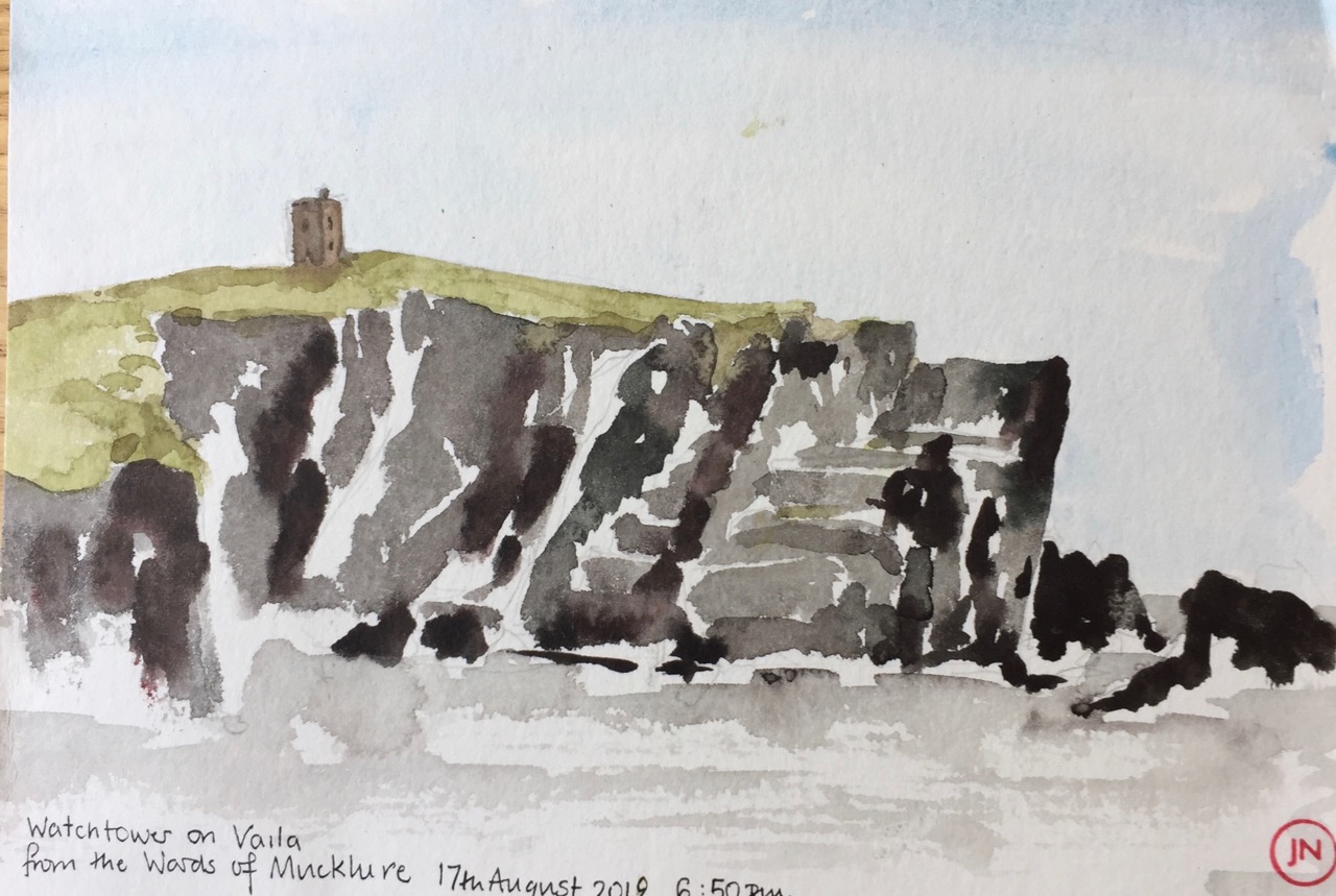
this. After all, he gave them very little, if anything for their catch. And the Icelanders would pay.

So he made the watchtower for surveillance. I was told this story in the Germattwatt café in Walls. The people made it sound as though it was living memory. But it was many generations ago, even if true. They also pointed out to me the place on the nearby hill where the miscreants were hanged, and left hanging, as an example.

The tower is listed as a project on the website of “Groves Raines Architects” as “Mucklaberry Tower, C19th 2-storey square plan Baronial reconstruction” . Their project was to refurbish it as a retreat, along with renovation of Vaila Hall.

On another day, from the beach, I determined to draw the rocks.

It was a very windy day, the wind blowing over the top of me.


IMG_3467 (1)

My rule for drawing rocks is this: everything that’s drawn is there, but not everything that’s there is drawn.


Shetland landscapes

Here is a collection of landscapes all done directly in watercolour with no pen and ink. I am using Daniel Smith Watercolours, and trying different mixing combinations. All of these pictures are done with three or fewer colours, alone or mixed together. It seems to me that the fewer the better. The picture hangs together better if I don’t use many colours. And it’s faster.

Click the picture to expand it.