The rocks off the ward of Mucklure are almost geometrical in their formations. They make abrupt right angles.
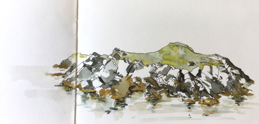
Here are the Skerries of Easter Paill, small rocks in the sea off Dounawall and The Hamar.
Here is another drawing of the same location. It’s hard to get an idea of the scale.
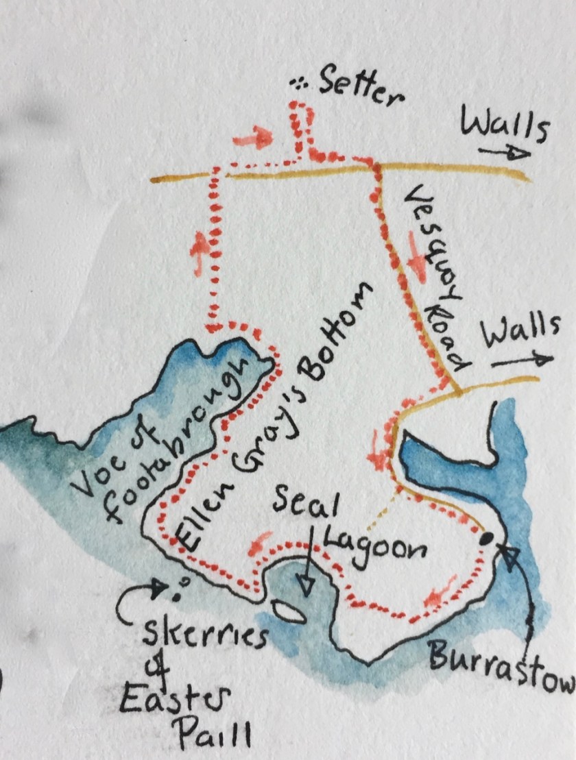
Here’s a map showing the location. I drew the picture sitting on a rock that was not pointed but smooth and rounded, at a convenient height. In fact, I saw the convenient rock first, and then thought, what can I draw from here?
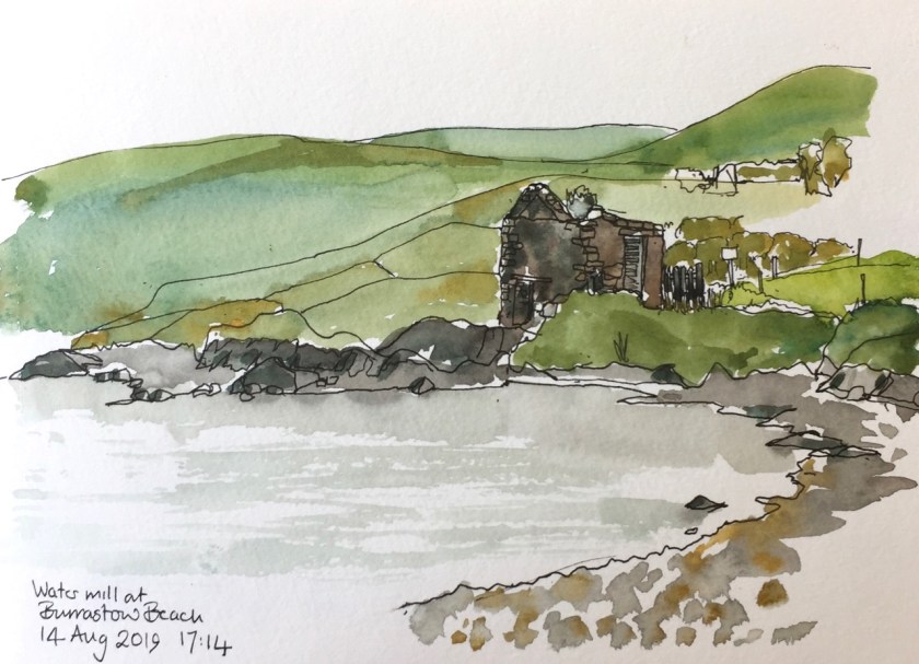
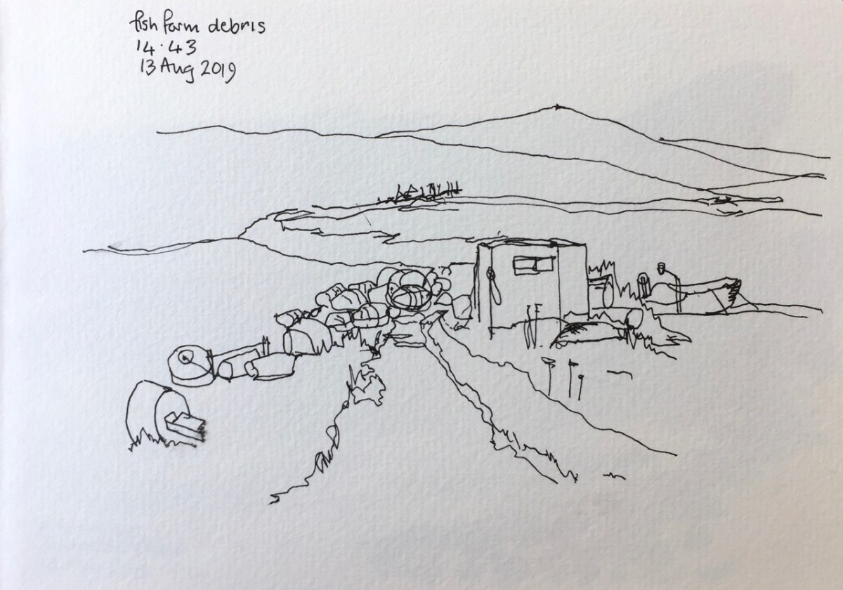
I had spotted a few items of plastic waste on the beach at the Seal Lagoon and intended to put them in my rucksack. But there was more and more, until they didn’t fit in my rucksack and I had a whole dustbin bag full. Then I realised I didn’t know what I was going to do with the bag. I carried it for the next hour, until I reached civilisation again, and found a bin. Moral of the story: don’t start collecting plastic waste until you have worked out a forward plan for the next step. This is a general life lesson, I think.
Click a button below to share this post online, email it, or print it:
The wooden sign from the main road said “Historic Site”, and pointed up a small road that lead steeply uphill. I was on my morning run and felt energetic, so I set off up there, keen to see the Historic Site. In Shetland, Historic Sites are often at the top of hills.
At the top of the first hill, there was no Historic Site, but a view of the next summit. I carried on. At the second summit there was no Historic Site either, just undulating hills in all directions. I was disheartened. I was also a long way from home base.
I turned around. In the distance was the island of Foula, which lurks on the horizon, looking menacing. Usually it’s seen across the sea. But from that second summit, Foula hovered above the green hills, too large, too grey, too abrupt in its cliffs. As I started running back downhill, Foula sank reluctantly, until it disappeared below the horizon and all around was again soft green hills, and sheep.
The next day I resolved to find the Historic Site. I went on a mega-walk. Here is my route:
You see marked the “Germattwatt Café” where I stopped on the way.
I found the Historic Site which, against all expectations and precedent, was not at the top of any hill, but low down. near the sea, on a promontory, and near a fishing lake. There were low ancient walls, and the distinctive patterns of undulations that indicate a dwelling, property divisions, field boundaries.
In tribute to the wisdom of the ancestors who chose this place I stopped a while. There was a good view up and down the estuary. Good fishing was to be had, both freshwater in the lake, and salt water in the sea. Such fishing was still being had. In the sea was the fish farm and the mussel farm. I drew a picture:
You see the stones of the Historic Site in the foreground. In the distance the “A971” makes its way East at the foot of the hill. The lines in the sea are the mussel farm. The high hill is the Ward of Browland. Here’s the Ordnance Survey Map. The arrow shows the direction I was looking when drawing the picture.
Then I walked on, following the sea. Here’s a drawing near the “pier” circled in red on the map.
The whole walk was 22km, and took 8 hours, including two hours of stops for drawing, refreshment and looking at the view.
Click a button below to share this post online, email it, or print it:
I went through Aberdeen on the way out to Shetland, and on the way back.
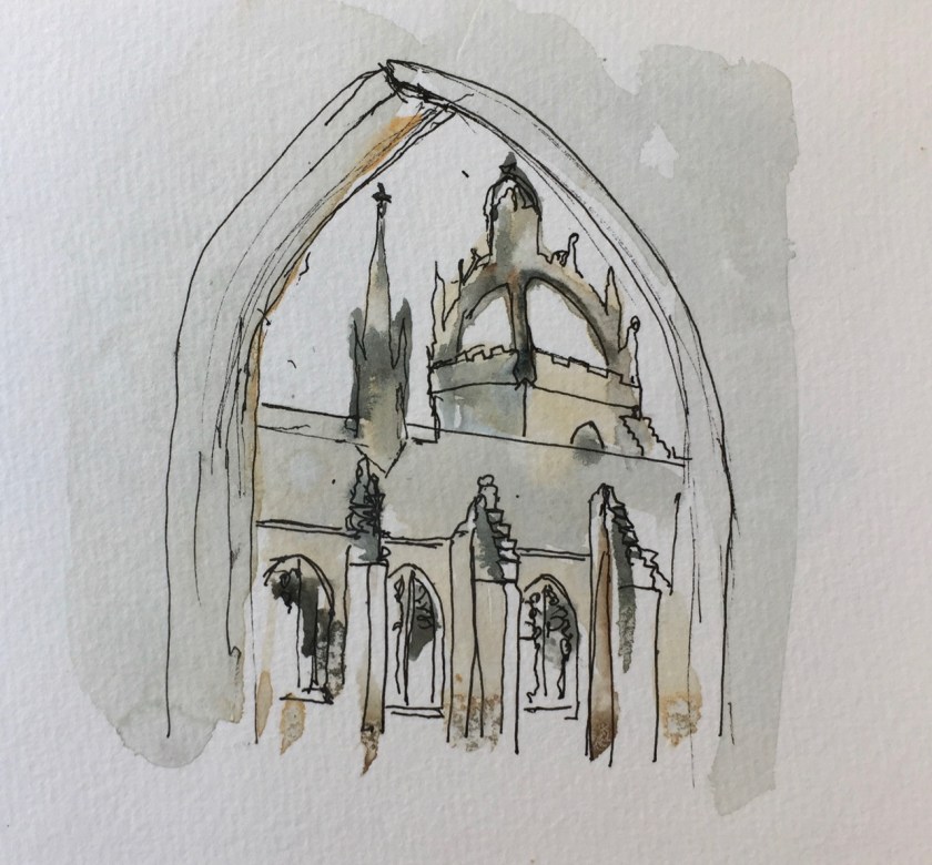
On the way out I drew St Machar’s Cathedral then proceeded south to find the excellent coffee shop Kilau Coffee recommended by the church guardian, who knew her coffee shops. By then I was in the University. It was still raining. So I sketched Kings College Chapel, from a convenient cloister.
Kings College Chapel, Aberdeen, from the cloister. 9th August 2019 15:21
Then I walked back to the ferry terminal, still in the rain. Here’s a sketch of a building on the main square.
Aberdeen Market Square, 26 Castle St, 9th August 2019
I was taken by the multiple levels of bartizan, which are the towers fastened to the side of the building. These are also called courbelled tourelles. I was sketching from the doorway of a charity shop, in biro, which was the only medium that worked in the sluicing dampness. I tried to find out what this magnificent building was. It seemed only to have a number: “26 Castle Street A-H”, so I guess it is residential.
From the window of my cabin on the ferry I saw the same building from a distance.
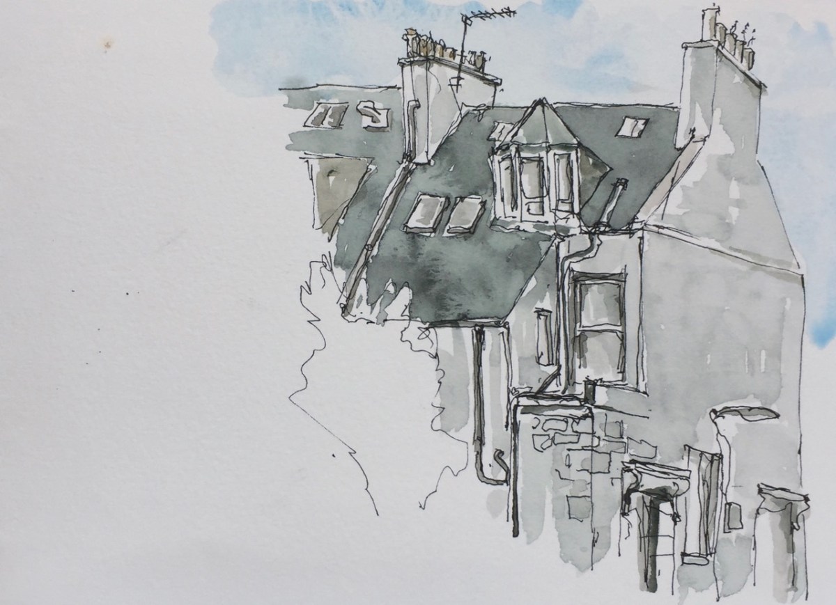
On the way back, two weeks later, I took a walk round what I termed the “Starbucks side of town”. This is the part south of the railway station. There is indeed a Starbucks, on Union Street. The houses are grand here, and in orderly terraces. Here’s a glimpse of an end house, a quick sketch as I was on my way to the bus station.
Aberdeen Houses, Rosebank Terrace numbers 2 and 4, 11am, 25th August 2019
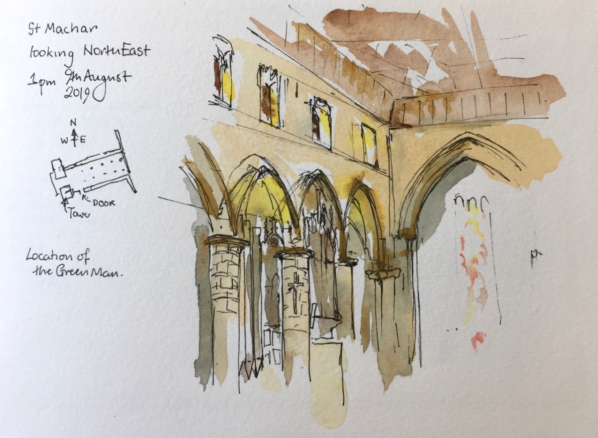
St Machar’s is in Old Aberdeen, North of the University.
I went to look for a medieval carving, a “Green Man”. According to my instructions it was in the “North East Crossing” on the “west side”. I had a good look around. This is a very plain church, solid granite columns, no carving. I could see no “North East Crossing”. The church is rectangular, not cross-shaped like most churches. The enthusiastic guardians welcomed me, and told me about the church. It is very ancient, and many different peoples have worshipped there, including the Celts, whose 7th century stone cross stands at the west end.
After I had listened and chatted, I showed them my instructions: “North East Crossing, west side”. Ah, they said, but there is no longer any “North East Crossing”, it’s been demolished, for centuries, since the Reformation.
I felt a shiver as though someone was telling me a ghost story. My instructions came from a printed book, much later than the Reformation, clearly. But the guardian was still talking. “You can see the ruins,” she was telling me, “Outside”.
Outside it was raining, a heavy wet Aberdeen rain. I stomped about in wet grass, between gravestones. I was looking up, which made me more wet. And there he was, the Green Man, staring down. I risked taking my iPhone out of my pocket for an instant, to get a photo.
I couldn’t draw outside, so I went back inside. The picture I drew shows the position of the Green Man, but the inside wall. He is on the outside.
9th August 2019, St Machar’s Cathedral, Aberdeen, now Church of Scotland, formerly Celtic, Roman Catholic, Episcopal.
Click a button below to share this post online, email it, or print it:
The ferry from Shetland arrives in to Aberdeen at 7am. The air feels cool and chemical, like water from a cold tap. I carry my luggage on my back, and it’s heavy.
No, they won’t take my bag at the ferry Left Luggage. Only if I’m travelling on the evening ferry will they take in my luggage. I am not travelling on the evening ferry. I have just arrived on the morning ferry. And I am going to the airport. But that is later. For now I have a heavy bag, and the whole of Aberdeen to explore.
Let’s try the train station.
It is Sunday. Aberdeen is closed. The Union Square shopping centre is closed. So the route to the station is three sides of a rectangle, a circumnavigation of the Union Square, Jury’s Hotel and the Bus Station. Outside the Jury’s Hotel, a cluster of men with beer cans part to let me through. My grim determination is reflected in their faces. Or perhaps it’s something else I’m seeing: their effort to stay vertical.
I spot the “Left Luggage” symbol at the Train station. The door has a dim window which frames a seated man. “I see the Left Luggage operative,” says my optimistic brain. The straps of my luggage are now making permanent furrows in the muscles of my shoulders. The door is locked. I rattle it. “It opens at nine,” comes a voice. It’s the seated man, who is behind me, reflected in the dirty glass. He is sitting on the sunlit steps, waiting.
From the table at “Patisserie Valerie” I can see that he is still there. He hasn’t moved at all. Those steps must be cold, granite. He must be fed up. But he didn’t seem fed up when I spoke to him. Perhaps he is sitting there for some other reason. Perhaps he does not require the services of the Aberdeen Station Left Luggage.
I do, though. I order breakfast at Patisserie Valerie. The glass and steel of the modern shopping centre cuts the view into bits. I can’t draw it all, so I draw a segment.
A bit of the Station Hotel, Aberdeen, from the Union Square Shopping Centre, Patisserie Valerie.
That odd curl in the top right is the “e” of “Union Square” written on the outside in modern 3D lettering.
Here is work in progress.
Line drawing before the tone went on
The view from Patisserie Valerie
Line drawing before the tone went on
The picture and the view
Exactly one hour to draw, including eating breakfast. Patisserie Valerie opens at eight. The Aberdeen Station Left Luggage opened at nine.
When I went there, the seated man had gone.
Click a button below to share this post online, email it, or print it:
Here is St Giles Church from the Lakeside Terrace of the Barbican. While I drew this, three men were shovelling mud from the bottom of the lake. The mud is black and viscous and the men were remarkably cheerful in their task. They would have made good subjects for a drawing too. But for now, here’s the church:
The church features in some of my “Tower” sketches:
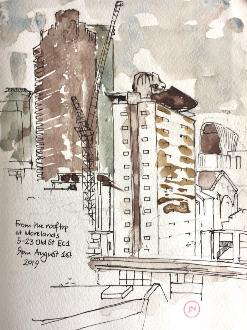
This was an event organised by RIBA* and Phil Dean a.k.a “Shoreditch Sketcher”. Morelands is a modern office block on Old St.
I looked south, and drew Cromwell Tower and Great Arthur House. This sketch took about 45 minutes, as darkness fell.
The “brise soleil” on top of Great Arthur House must be one of the most difficult things to draw. That, and the dome of St Pauls. Because it’s curved, and the curve needs to be right.
Earlier, I did a sketch of the “brise soleil” on its own. I had not noticed before that there is a sort of balcony.
Today I found another view of the view under Mountjoy. This is from the high walk that goes north from the Museum of London, looking East.
Under the Mountjoy Highwalk there are a number of “framed” pictures. The old London Wall fortification is visible. The sun reflected from the lake and threw patterns onto the old stone. I couldn’t get all that in the picture so you have to take my word for it.
A group of tourists stopped on the “Wallside” highwalk. You can see them in the centre right of the picture.
These “windows” will all be obliterated by the proposed City of London School for Girls expansion.
This view is from the place where the north bound highwalk turns abruptly left (click map to expand it).
This picture took about an hour. I tried hard not to overdo it.
At the top of the picture are the flats of Mountjoy House, with their impressive window boxes.
Click a button below to share this post online, email it, or print it:
This is the view that will be lost if the City of London School for Girls expansion proposal goes ahead.
UPDATE (2020): the proposal has been shelved, and alternatives are sought. But we must remain vigilant. The article below was written in August 2019, when the threatened development looked as though it would go ahead. Widespread protest ensued.
The view that will be lost if the CLSG expansion goes ahead. See “SOSBarbican.com”
I spent time today paying attention to this view, because that is what I need to do, to draw it. The pillars are reflected in the water. The enormous flight of steps is like that in a fairy story, so wide and grand. There’s a massive three-dimensional sculpture of concrete, of light and dark. Flat spaces and lines don’t quite join up but are nonetheless connected, like rhythmic music. Framed by the 20th century brutalist columns you see an older more ornamented building, and trees. You can even see right through to the other side of Aldersgate. This is a magnificent view.
The interesting blotchy effect on the pillars is rain falling on the picture. I started this picture at 09:30. Then it started to rain. The fine rain speckled my picture. Bigger drops diluted the paint in the palette and made the paints shift about. Then it started pouring down with menace. I scrabbled my things together and dashed into St Giles’ Church which was behind me. Inside the church, people moved purposefully about, and all was calm. And it was dry. I took a deep breath and kept my drawing horizontal. There was a table next to the door. A woman looked at me over the table. I felt the need to explain. “I’m sheltering from the rain,” I told her.
Her response was calm and logical, “Would you like a cup of coffee?”
“I would,” I said. Her companion at the table offered me a biscuit. Grateful to the Royal Society of Organists for their hospitality, I sat on a wooden bench and let my drawing dry off. Experimental short tunes from the organ floated quizzically in the air.
Then I went out again. I wanted to finish my picture. I stood in the porch of the church and looked at the rain. “Every decision is a moral decision.” I believe that. Should I pack up the drawing and go home? I could use the time before the Planning Meeting to do the supermarket shop, deal with the plumbing problem, and process the sourdough.
Or should I continue the drawing?
What principles are at stake here? I finish drawings that I start. I don’t mind the rain. My ink and watercolour does mind the rain, though. So I’ll draw the picture under an umbrella.
This was surprisingly effective. I managed to get all the ink drawn before 10:45, when I packed up again, to go to the Planning Meeting. During this time I was approached by a flustered gentleman in a smart suit, who wanted to “get across the lake”. He was hopelessly disoriented, pointing South-West, when he should have been heading North-East. I re-directed him and he dashed off towards the Barbican Hall.
The Planning Committee Meeting at 11am was the City of London Planning and Transportation Committee. This was their July meeting. In their September meeting, if things go according to the plan put forward by the School, this same Committee is due to approve a plan for a building which will totally block out the view I have drawn. The proposed new structure would cover the steps, build round the pillars, and put in an industrial kitchen. Residents in Mountjoy House, directly above my picture, are understandably dismayed. The Barbican Association, representing Barbican residents, is leading a campaign to prevent to save the view, and stop the expansion. Here is their postcard/flyer.
On the way back from the planning meeting, I went back to the view, and put the colour.
Spending time looking at this view, these pillars, these shapes, I realise how magnificent it is, and how talented the architects were. This view is worth fighting for.


 The wooden sign from the main road said “Historic Site”, and pointed up a small road that lead steeply uphill. I was on my morning run and felt energetic, so I set off up there, keen to see the Historic Site. In Shetland, Historic Sites are often at the top of hills.


 This was surprisingly effective. I managed to get all the ink drawn before 10:45, when I packed up again, to go to the Planning Meeting. During this time I was approached by a flustered gentleman in a smart suit, who wanted to “get across the lake”. He was hopelessly disoriented, pointing South-West, when he should have been heading North-East. I re-directed him and he dashed off towards the Barbican Hall.


