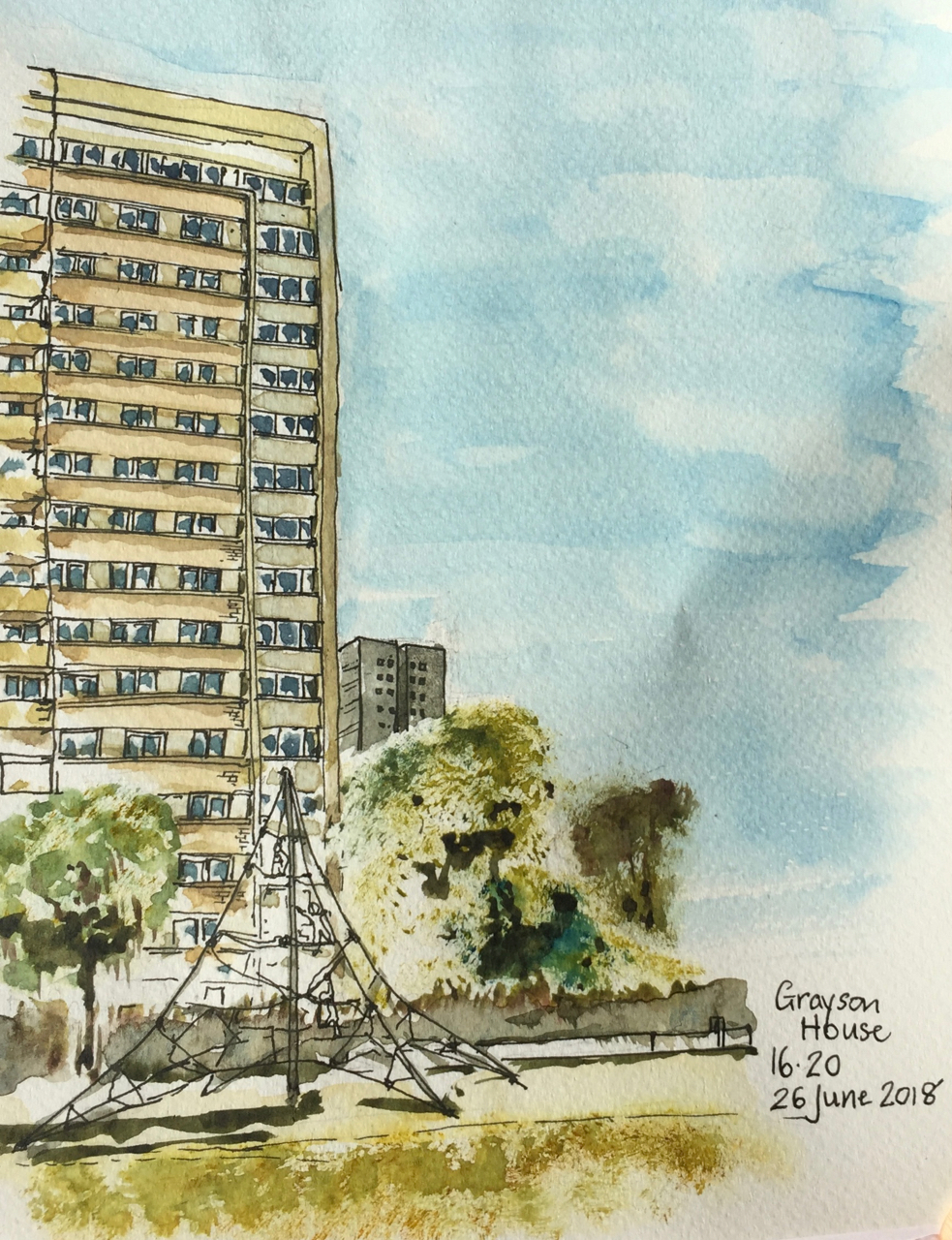
1 hr 40 mins from the small park called Radnor Street Gardens.
Grayson House on the left, and Gambier House in the background.
Next to me, for the entire duration of the drawing two men played ping-pong. The children came out of school at 4pm, and wanted to use the ping-pong table. But the men said no.
Later note:
I discover from the amazing “Streets with a story, The book of Islington” by Eric A Willats FLA, that “Grayson House (1961)” was ” named after Frederick George Grayson, a superintendent of Radnor Street Sunday Schools and Mission, formerly in Radnor Street.”
Mr Willats’ book lists streets and some buildings in Islington, including as he says “what has come to my notice up to the early summer of 1986.” It is in the Islington Museum.
Click a button below to share this post online, email it, or print it:
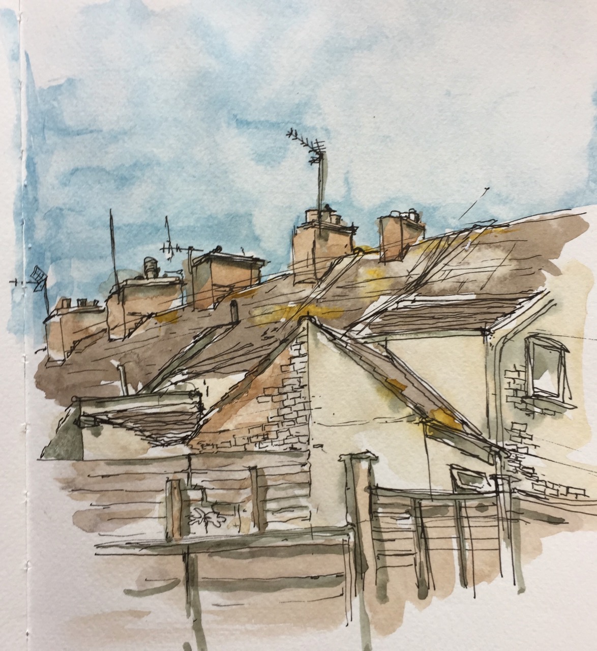
Here are the roofs of a terrace of houses in Kessingland, near Lowestoft. The date on the terrace is 1860.
Each house, originally identical, has now its own idiosyncratic extensions and extra roofs. All the chimneys are different. Crows called all the time while I sketched.
Here’s the view over the back gardens.
See all the washing lines, hauled up using nautical pulley systems. This picture was done in almost exactly the same position as the one of the roofs, but looking in a different direction.
Both pictures, pen and wash in a Jacksons watercolour sketchbook.
Click a button below to share this post online, email it, or print it:
Walking on Kessingland beach, the sun shone and the wind blew. The greyhounds ran about wildly, but, in the manner of greyhounds, were soon ready to go home.
Watercolour on Vintage Handmade paper 150gsm, from the Vintage Paper Company.
Click a button below to share this post online, email it, or print it:
St Alphege (“Ælfheah”) was a Bishop of Winchester, later Archbishop of Canterbury. He was captured by Viking raiders in 1011 and killed by them the following year after refusing to allow himself to be ransomed. Alphege was canonised as a saint in 1078.
The church was built around then, according to Wikipedia: “The first church was built adjoining the London Wall, with the wall forming its northern side.The churchyard lay to the north of the wall.The earliest mention of this church dates to c. 1108–25, though it is said that it was established before 1068.”
The ruins of the Church have recently been made beautiful, and accessible, by the wonderful new public space around One London Wall Place. Here is is a sketch done from one of the wooden benches close to the church:
You see the marvellous new high walks, which curve in the sky.
Until I started drawing them, I had not realised that the walls of the highwalk vary in height. The highwalk is made of some material which rusts, to give this bright orange colour.
On the right of the picture is the red brick of the old London Wall. The building in the background is Roman House, on Wood Street, a residential block.
The architects of One London Wall are MAKE architects.
About 2 hours, drawn and coloured on location, in Jackson’s watercolour sketchbook.
Click a button below to share this post online, email it, or print it:
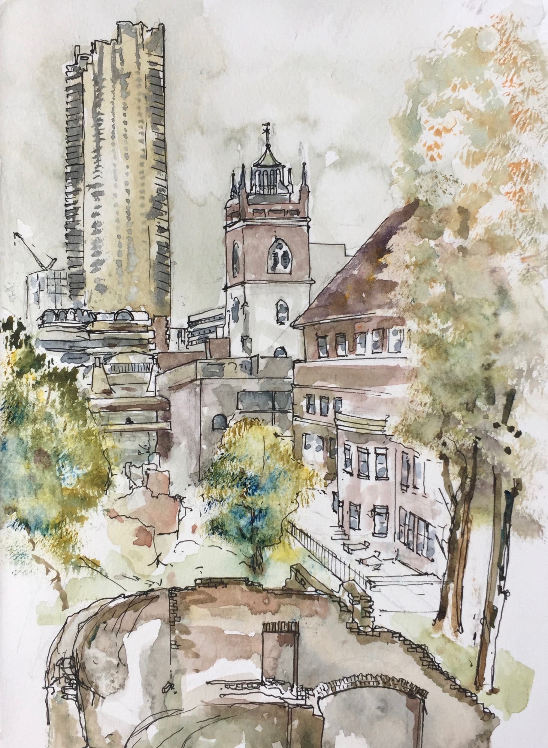
Here is a sketch from a staircase from the Barbican Podium, just outside the Dentists but just inside the old London Wall.
Parts of the Roman London Wall are in the foreground, 2nd century AD.
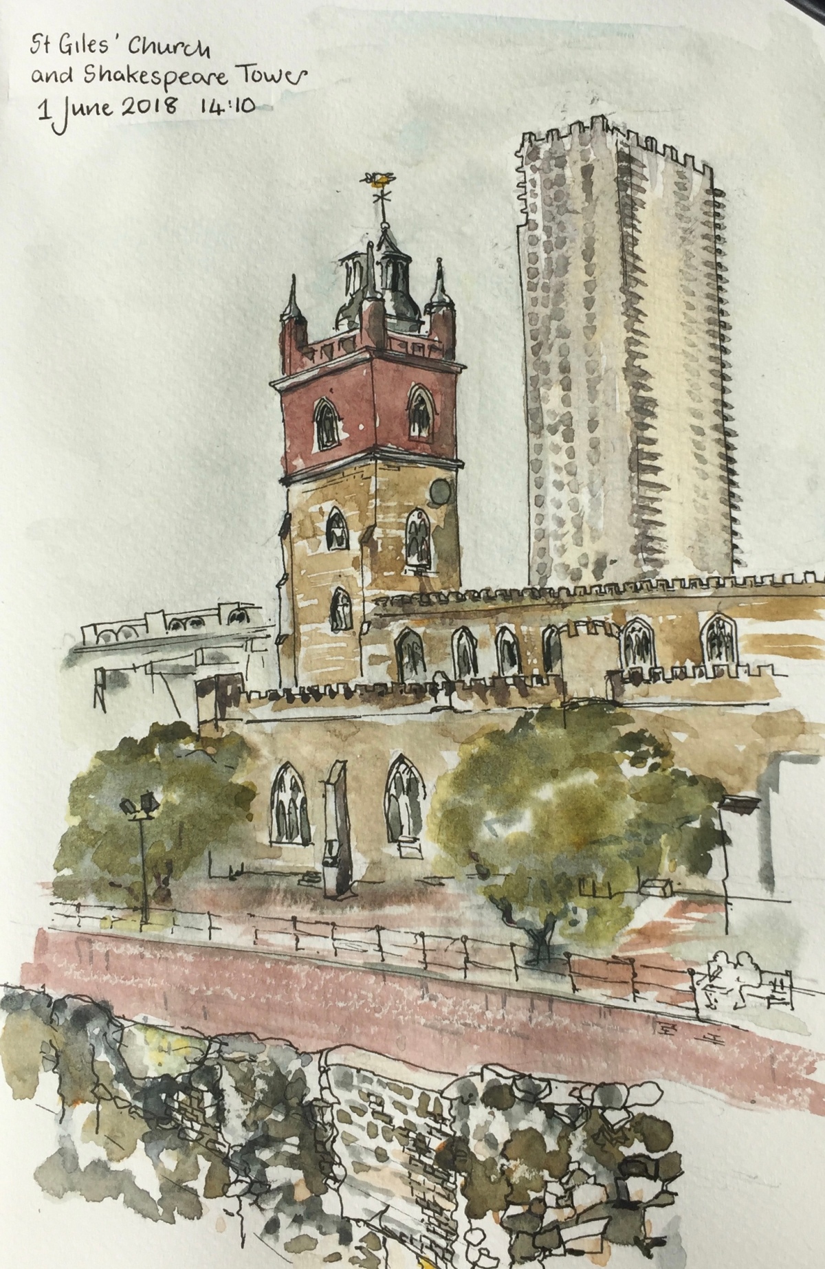
St Giles’ has Roman foundations and is much rebuilt. The church we see now is the 1966 restoration following designs of architect Godfrey Allen (1891-1986). He used historic plans to make the church as much as possible like the medeival original. It had been burned by incendiary bombs in 1940.
In the background is Shakespeare Tower, Barbican, completed 1976, to the designs of Chamberlain, Powell and Bonn.
St Giles’ Church is “St Giles’-without-Cripplegate”. As you can see from the picture, the Church is outside London Wall. Here is an extract from the St Giles’ website.
The foundations are generally Roman but higher up, the structure dates from various times as it was regularly strengthened and rebuilt…. As the population of the parish increased, the church was enlarged and it was rebuilt in the Perpendicular Gothic style in 1394, during the reign of Richard II. The stone tower was added in 1682. The church was damaged by fire on three occasions – in 1545, 1897 and 1940…The church was designated a Grade I listed building on 4 January 1950 and it was extensively restored in 1966.
…
The bombing of Cripplegate in 1940 was so extensive that barely any buildings remained standing in the entire ward. By 1951, only 48 people were registered as living within the ward. It was this widespread devastation which led to planners envisaging and eventually building the modern Barbican estate and arts centre, starting in 1965.
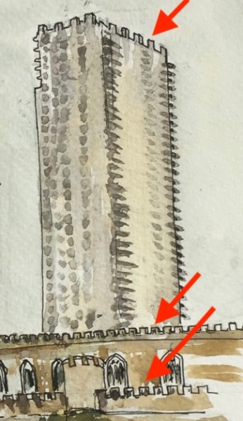
As I was drawing, I saw that the crenellations on St Giles were echoed high up on Shakespeare Tower.
The drawing took two hours, pen and wash, in a Jackson’s Watercolour Sketchbook.
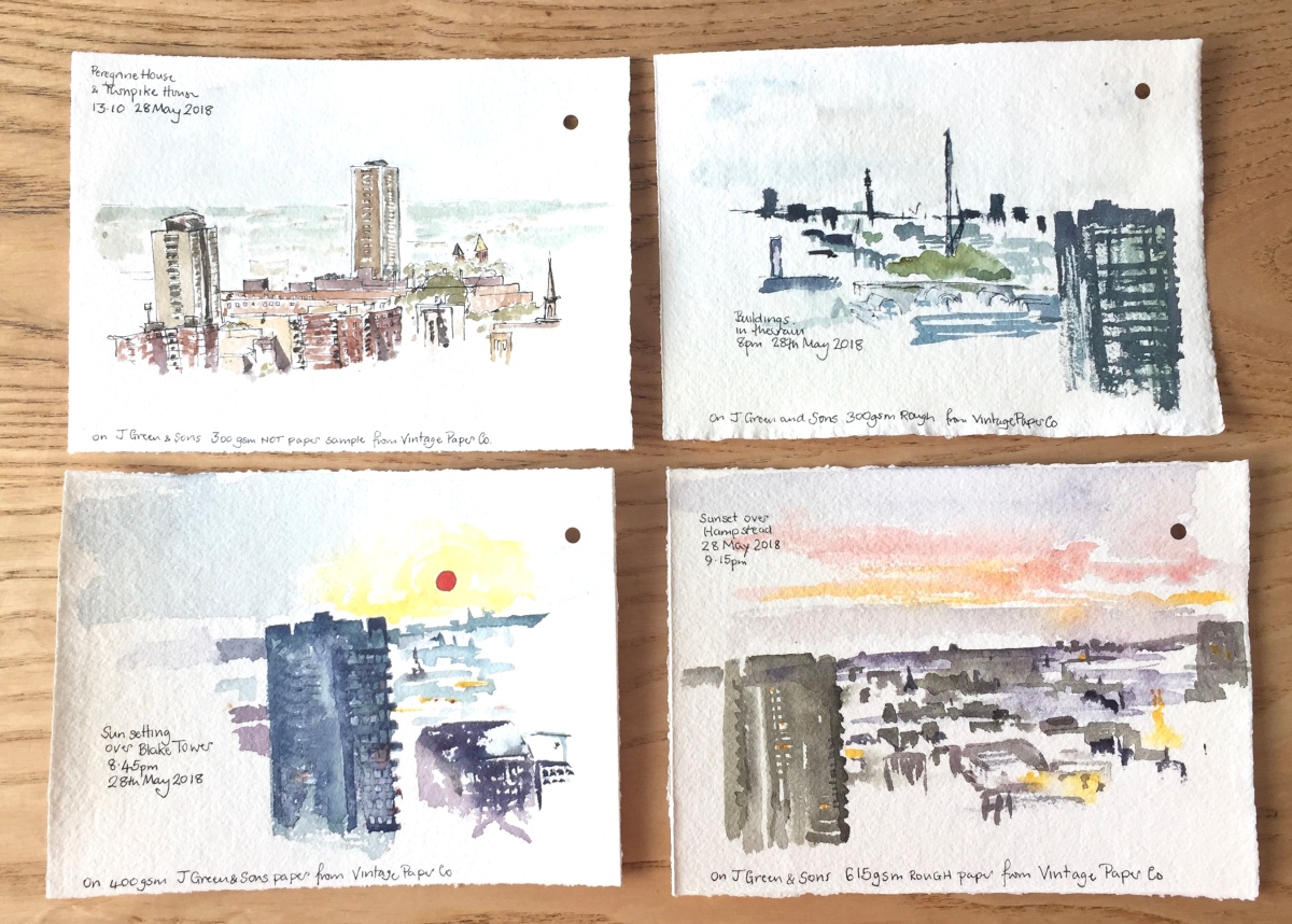
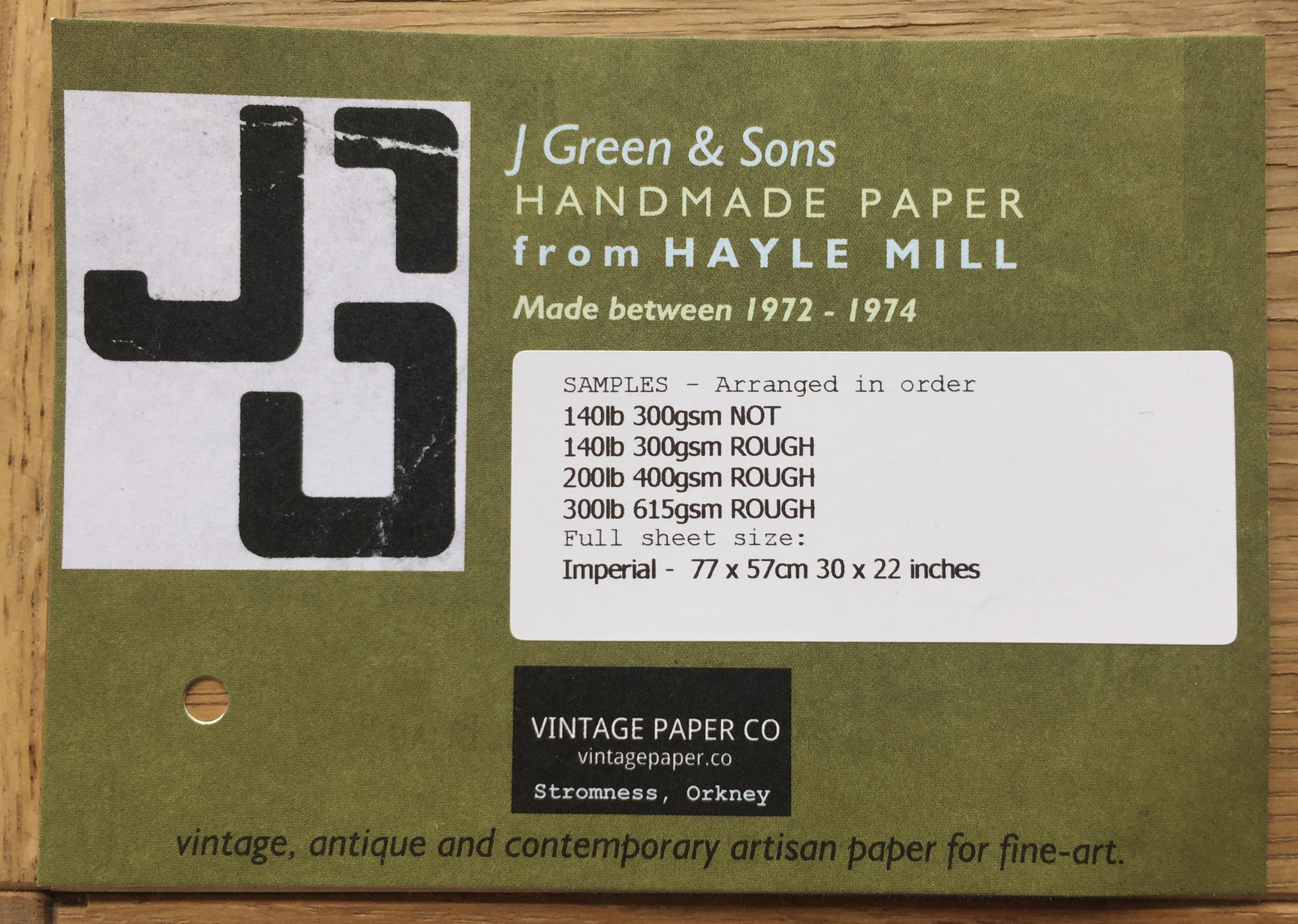
Each sheet is of “J Green & Sons” paper, in different weights. The one in the top left is “NOT” and the other sheets are “Rough”. Each sample sheet is about 8 inches by 6 inches.
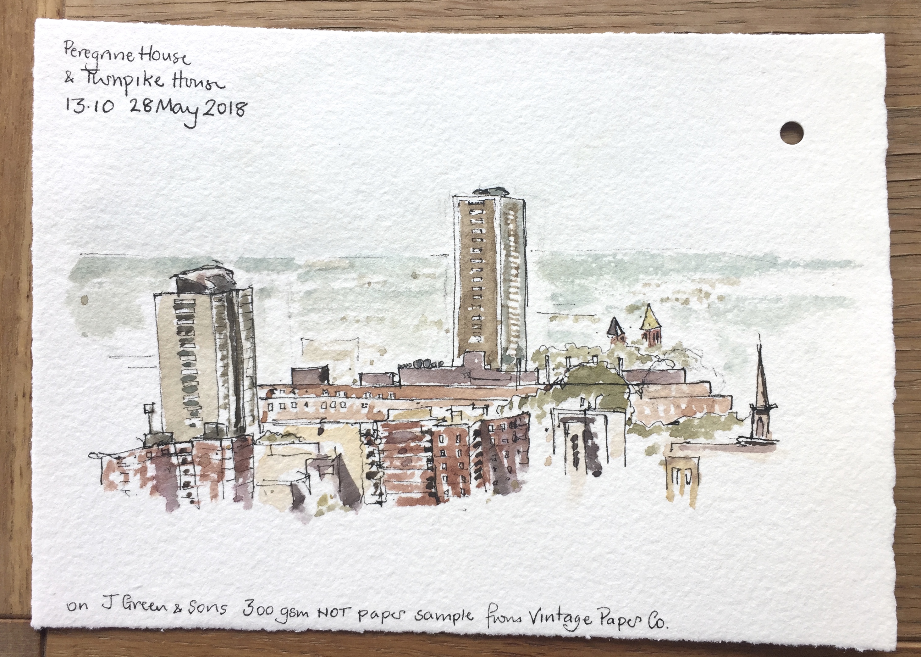
Here is a view towards Peregrine House, to show the satellite dishes on the roof. I also drew Peregrine House last week, see this link: Peregrine House from the King’s Square Estate
The hole in the top left corner is where the sheets were fastened together, with a neat little screw fastener.
Paper fastener – 1cm in diameter
Paper fastener unfastened
This was the only paper in the same pack with a ‘NOT’ (smoother) surface. Here is a close up view of the satellite dishes. On the NOT surface I can use pen easily. Pen and ink doesn’t work so well on the “Rough” surface. Here’s a close-up, showing Peregrine House and the satellite dishes on the building in front of it.
Below is a sketch out of the window in the rain: watercolour only, on the “Rough” surface 300gsm paper. Blake Tower is on the right, Post office Tower on the horizon, Barbican terrace block visible behind Blake Tower.
Forty-five minutes later, the sun was setting. I enjoyed using heavier paper (400gsm) to try to capture the shimmering light on the buildings. Painted directly in watercolour, no pen, no pencil.
Below is the final sketch, done quickly after the sun has set. This is on the heaviest paper, a magnificent 615gsm. It was stable, like card, so it didn’t curl or misbehave, and was not soft or absorbent, but took the watercolour brilliantly. It was very handy for such a quick sketch.
It’s fun to experiment with papers, and surprising what a difference the paper makes. Thankyou to the Vintage Paper Co for the samples.
Click a button below to share this post online, email it, or print it:
At 27 stories, Peregrine House and Michael Cliffe House are the two tallest towers owned by Islington Council. This sketch shows Peregrine House, an Islington Council residential tower, visible from my window. It is on Hall St, just off the Goswell Road. The view is looking North towards Peregrine House. I was standing in the Kings Square Estate, another Islington Council Estate, next to Rahere House.
Peregrine House was finished in 1969. It is part of the City Road Estate, together with Kestrel Tower. I have drawn Kestrel Tower previously, see this link: Towers of Finsbury – Rahere and Kestrel. See the different brick colours on Peregrine Tower: the more yellow brick for most of the balconies, and the more red-coloured brick for the balconies across the top and around the sides.
The solid neo-Georgian block in front of Peregrine House is “Level 3 communications” a data centre and communications hub. In 2011 they applied to Islington Council for permission to install 5 steel flues. The permission was granted and the flues are on the back (north) of the building, not shown in the sketch. As part of the consideration of the permission, the building is described as “1930s”. I haven’t yet found out what it was before it was a data centre. It looks like a telephone exchange or electricity substation. (Update: 6 February 2019 – it was a Gordon’s Gin Factory – see comments below) I drew the back of this building in the Kestrel Tower sketch: Towers of Finsbury – Rahere and Kestrel
Photo from the Level 3 application to install satellite dishes. I think that’s Micheal Cliffe House in the distance.
Level 3 also applied for permission to install 4 satellite dishes on the south side of the building. The application is undated, and no indication is given of the outcome. This application was “retrospective”. Link to their application is here: Level 3 Application for Satellite Dishes
I was looking at the South face of the Level 3 building and I couldn’t see any satellite dishes.
In the foreground, right, of my sketch, is the blank end-wall of 6 Moreland Street, an Arhag Housing Association residential building, which looks like a late 1970s development.
The Kings Square Phase 2 development, picture from the Higgins Construction website. It’s a bit hard to tell, but I think that’s a similar sightline to the one in my sketch, with Peregrine House in the background. Picture credit: Pollard Thomas Edwards architects.
In the foreground on the left, work is in progress on “Kings Square Phase 2” which a hoarding informed me was “93 new homes”, which are “51 council homes and 42 for private ownership”. Completion is due in 2020, and they’ve already got the concrete frame up. The construction workers were working hard and calling to each other while I sketched, issuing instructions and shouting warnings in several languages, including English. The contract was awarded to Higgins Construction plc in February 2017: £30 million.
The sketch took 90 minutes: half an hour each for pencil, pen and watercolour. Done in Jackson Watercolour sketch book, 8 by 10 inches.
If the lighting looks flat and there is a complete absence of shadows, that’s because the lighting was flat and there was a complete absence of shadows. It was that kind of a day.
Later note:
I saw the satellite dishes on the Level 3 building, they are high up on the roof and not visible from ground level.
Here they are:
Sketch 28 May 2018, from my window.
Click a button below to share this post online, email it, or print it:
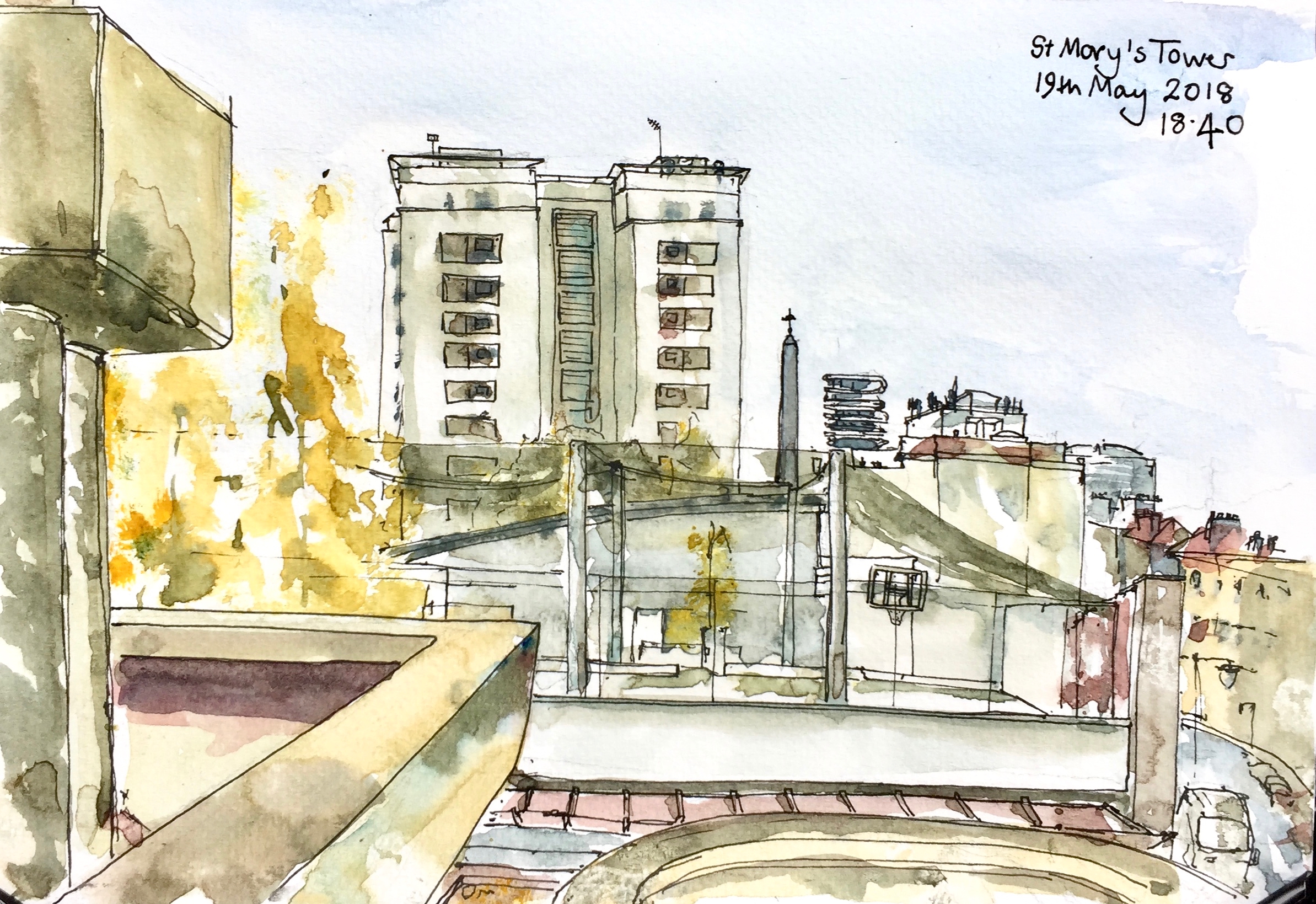
This sketch shows St Mary’s Tower, in the Roscoe Street Estate. Prior Weston School is in front, with its first floor playing pitches festooned in black net. The pinnacle of St Luke’s is just to the right of St Mary’s Tower, followed by “Cannaletto” the black and white striped modern tower block, then Coltash Court, the tower block at the north end of Whitecross Street . The south of Whitecross St is to the far right of the picture. The tower block in the background on the right is Godfrey House.
St Mary’s Tower was built on church land by the Peabody Trust. It was completed in 1957. The architect was John Grey and Partner.
St Mary’s Church was built in 1868, but was then demolished having been badly damaged in the Second World War.
The Tower now forms part of the Roscoe Street Estate, managed by Islington.
Sketched from the Barbican podium, in about 2 hours. A cool, sunny spring afternoon, with the wind curling the paper. Jackson’s watercolour sketchbook, 7 inches by 10 inches.
St Mary’s Tower features in my etching “Towers East”.
Click a button below to share this post online, email it, or print it: