Sunday stroll in the City

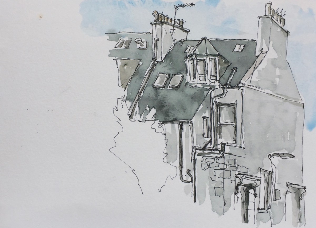
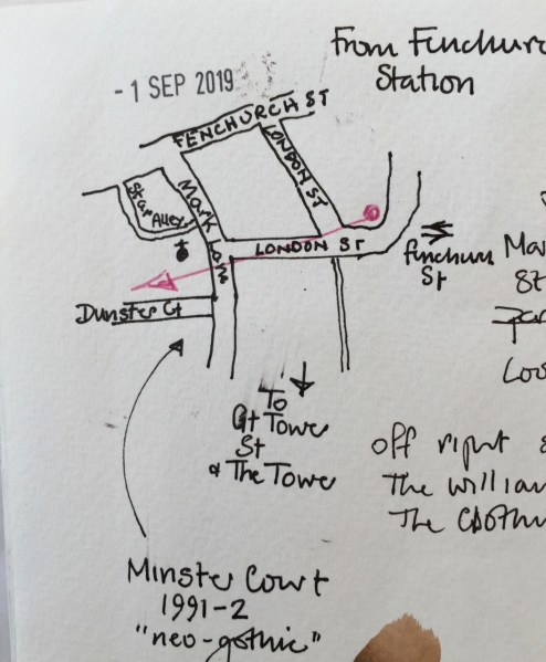
From Fenchurch St Station there is a stunning architectural view. I sketched it, standing outside the station. This was not a great place to stand. I put the colour on later, sitting down in the wooden seats nearby. A woman with a bike came by and told me someone had let down both her tyres. Why would they do that, she asked me. Why indeed. She went off, pushing her bike on its flat tyres. Her dog followed on its lead, disgruntled,  catching the mood of its mistress, deprived of a ride in the special dog-basket on the back of the bike.

IMG_3518
From Fenchurch St Station, looking West, along London Road

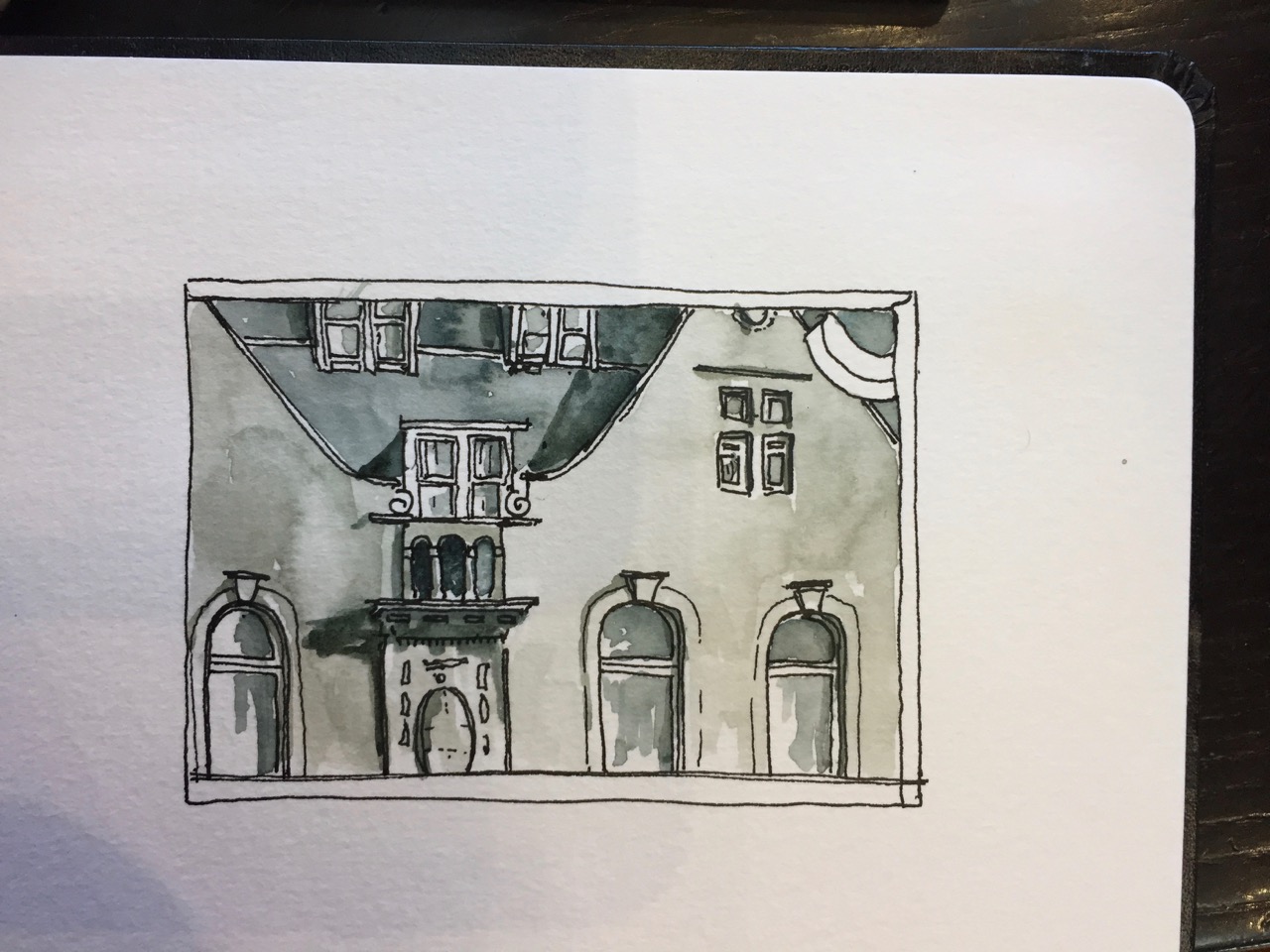
Shown in the picture on the left is “Minster Court” a pinkish coloured Neo-gothic building built in 1991. It contains, amongst other things, the “London Underwriting Centre” and “Proud Cabaret City”, and a branch of “Balls Brothers”, a pub.

IMG_3520
Sketch map, showing the direction of the view from Fenchurch St Station.

The glass building is “Plantation Place” built 2004, by Arup Group. Accenture is in there.

Behind I hope you recognise the “Walkie Talkie” skyscraper. In front and centre is the Clothworkers Guild. The little building at the bottom is St Olave’s Church Hall. St Olave’s Church itself is a lovely tower, which I would have seen if I’d moved slightly to the left. It’s behind the ponderous dark building on the right. I’ll go back and sketch it another time. This is the church where Samuel Pepys worshipped.

I walked towards the river and sketched in St Katharine’s Dock.

This is the view looking West, from the East side of the dock.

IMG_3517
St Katharine’s Docks, looking West (IMG3517)

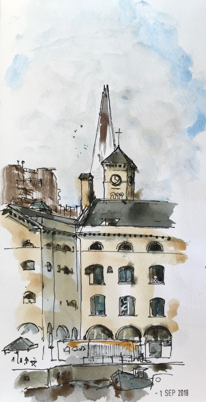
In the background on the left is “Guoman Hotels The Tower”, which is right next to the Tower of London. This hotel was built in 1973, one of the first buildings of the dockland re-furbishment. The Shard is in the background, centre.

The main building in the picture, former warehouses, is now called “The Ivory Building”. It appears to be residential. There were lots of bells to push, but I didn’t. I envy the person who has that turret. The clock was showing the correct time.

On the lower left is a restaurant with a sun umbrella. Its name was so tangled up in the fancy script of its logo that I couldn’t read it, something like “docole”.

Off the picture to the right a large rectangular stone was embedded at eye height. People rushed past, to the cafés and restaurants. The writing on the stone said:

“The foundation stone of Commodity Quay World Trade Centre London, laid on St Katharine’s Day 1985”

St Katharine’s Day is 25th November, in case you were wondering. Also spelt with a C.

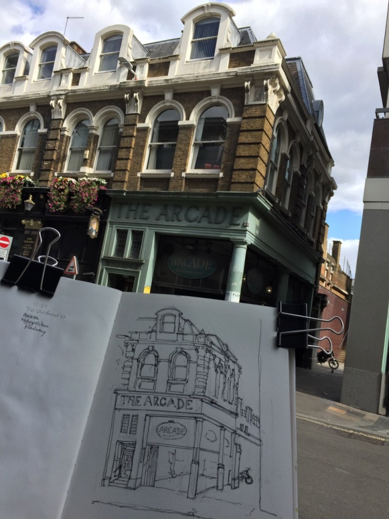
Here is my favourite picture of the walk, done on the way back.

IMG_3516
The Arcade, Liverpool Street

This is an astonishing construction, left over from an earlier epoch, and now surrounded by new-build and glass and steel office buildings. It is a corridor of shops, like the famous passages in Paris. But actually, not like them. Since it was Sunday, the Arcade was not trading. It was looking rather dilapidated. As I sketched, I saw tourists make their way in there uncertainly, in a characteristic pose of staring at the mobile phone and glancing about. Evidently Google was telling them that Liverpool Street Station could be accessed was down there. It cannot, not on a Sunday. As they entered the Arcade, they looked about. Then they really looked about, rather than comparing the world to the mobile phone map.  They suddenly saw the broken glass, dusty shop fronts and cardboard, and the feet and legs of someone lying on the ground. They abruptly turned around and came out again into the sunlight, staring accusingly at the phone.

The script which says “The Arcade” is beautiful.

IMG_3513

I particularly like the curved foot of the R, as though the letter is about to dance.

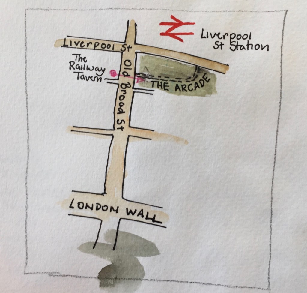
Here is work in progress, and a map:

Homelessness is a problem in London, even right in the centre of the financial district.

Shetland: Towards Vaila

There’s a beach near Burrastow that looks towards the Island of Vaila.

Here’s a sketch I made from the cliffs above the beach.

IMG_3489

Those cliffs look steep and dark. The tower is a “watch tower”, I’m told, built by the Laird back in the day (1700s) to watch over his fishing operations. The story I was told was that the Laird’s tenants were selling their catch to Icelandic vessels out there in the bay. Then they returned with a meagre stock for the Laird. Or at least he suspected them of doing IMG_3490
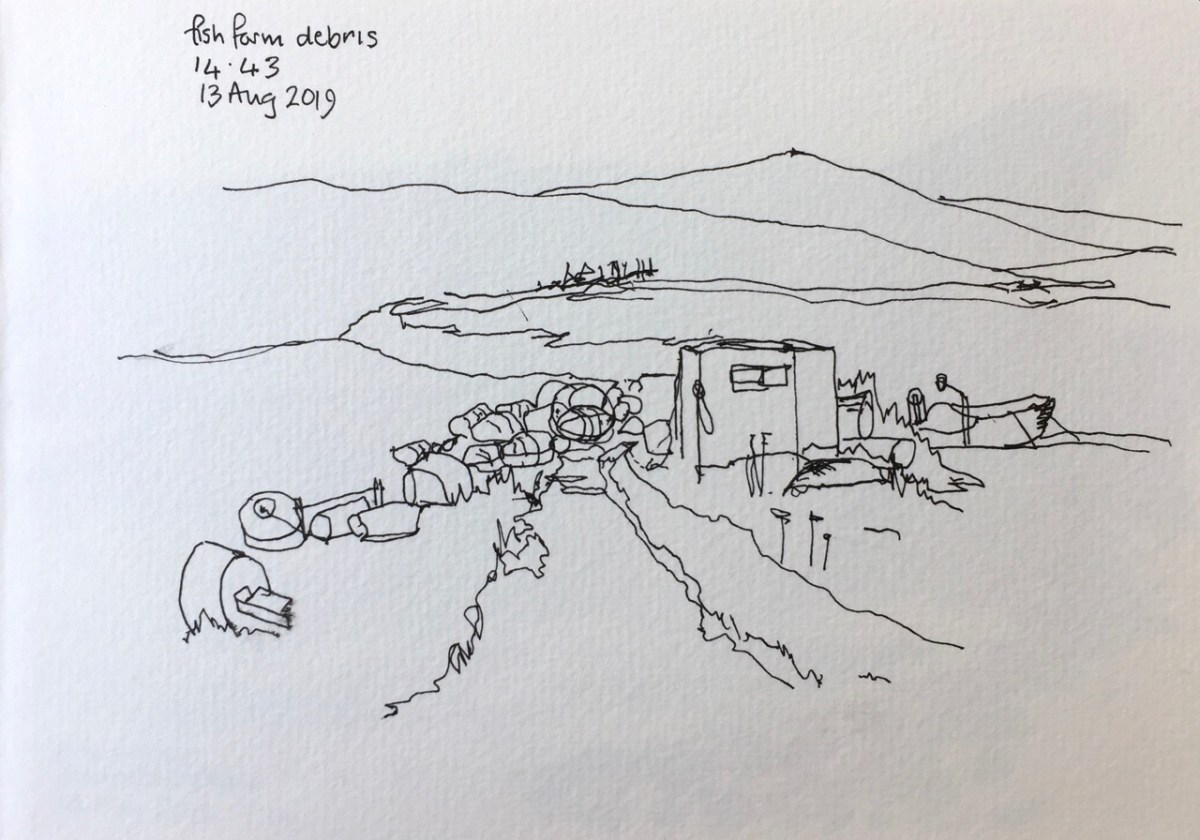
this. After all, he gave them very little, if anything for their catch. And the Icelanders would pay.

So he made the watchtower for surveillance. I was told this story in the Germattwatt café in Walls. The people made it sound as though it was living memory. But it was many generations ago, even if true. They also pointed out to me the place on the nearby hill where the miscreants were hanged, and left hanging, as an example.

The tower is listed as a project on the website of “Groves Raines Architects” as “Mucklaberry Tower, C19th 2-storey square plan Baronial reconstruction” . Their project was to refurbish it as a retreat, along with renovation of Vaila Hall.

On another day, from the beach, I determined to draw the rocks.

It was a very windy day, the wind blowing over the top of me.


IMG_3467 (1)

My rule for drawing rocks is this: everything that’s drawn is there, but not everything that’s there is drawn.


Shetland landscapes

Here is a collection of landscapes all done directly in watercolour with no pen and ink. I am using Daniel Smith Watercolours, and trying different mixing combinations. All of these pictures are done with three or fewer colours, alone or mixed together. It seems to me that the fewer the better. The picture hangs together better if I don’t use many colours. And it’s faster.

Click the picture to expand it.

Shetland, Skerries of Easter Paill

The rocks off the ward of Mucklure are almost geometrical in their formations. They make abrupt right angles.

Here are the Skerries of Easter Paill, small rocks in the sea off Dounawall and The Hamar.IMG_3492

Here is another drawing of the same location. It’s hard to get an idea of the scale.

Here’s a map showing the location. I drew the picture sitting on a rock that was not pointed but smooth and rounded, at a convenient height. In fact, I saw the convenient rock first, and then thought, what can I draw from here?

IMG_3496

I had spotted a few items of plastic waste on the beach at the Seal Lagoon and intended to put them in my rucksack. But there was more and more, until they didn’t fit in my rucksack and I had a whole dustbin bag full. Then I realised I didn’t know what I was going to do with the bag. I carried it for the next hour, until I reached civilisation again, and found a bin. Moral of the story: don’t start collecting plastic waste until you have worked out a forward plan for the next step. This is a general life lesson, I think.


Shetland 2019 – pen and wash

IMG_3471

Here are some pictures I drew in pen and wash.

I spent a lot of time drawing rocks.

IMG_3473
Rocks off Burrastow

The rocks are overwhelming in their detail. Not every thing I saw is in the picture. But every thing in the picture, I saw.

IMG_3465

IMG_3476

Here are some pictures I drew on the journey going back South:

IMG_3478
From the bus stop in Walls

And another one, really quick sketches:

IMG_3477
Another sketch from the bus stop in Walls

And here’s a sketch I did looking out of the window from my cabin on the boat.

IMG_3479

I sent a copy of this to PS, a magical person I met on Shetland. I was thrilled when she replied with a letter and a chart identifying the buildings:

Letter from PS.

On my next visit I shall walk over there and take a look.

Shetland, Historic site walk

IMG_3182
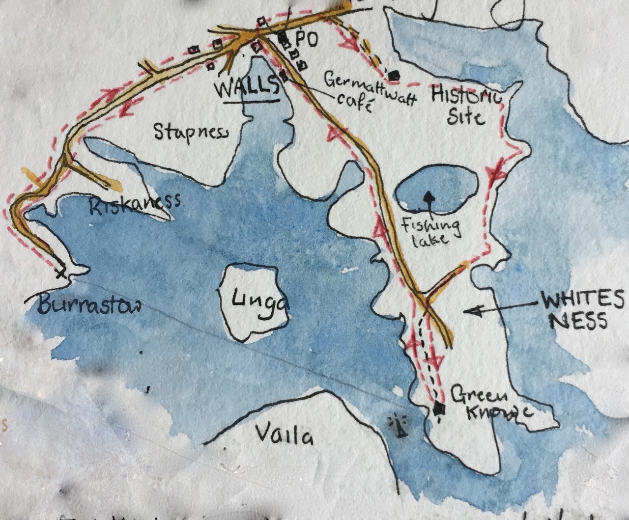
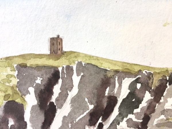
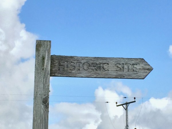
The wooden sign from the main road said “Historic Site”, and pointed up a small road that lead steeply uphill. I was on my morning run and felt energetic, so I set off up there, keen to see the Historic Site. In Shetland, Historic Sites are often at the top of hills.

At the top of the first hill, there was no Historic Site, but a view of the next summit. I carried on. At the second summit there was no Historic Site either, just undulating hills in all directions. I was disheartened. I was also a long way from home base.

I turned around. In the distance was the island of Foula, which lurks on the horizon, looking menacing. Usually it’s seen across the sea. But from that second summit, Foula hovered above the green hills, too large,  too grey, too abrupt in its cliffs. As I started running back downhill, Foula sank reluctantly, until it disappeared below the horizon and all around was again soft green hills, and sheep.

The next day I resolved to find the Historic Site. I went on a mega-walk. Here is my route:

IMG_3495

You see marked the “Germattwatt Café” where I stopped on the way.

IMG_3486

I found the Historic Site which, against all expectations and precedent, was not at the top of any hill, but low down. near the sea, on a promontory, and near a fishing lake. There were low ancient walls, and the distinctive patterns of undulations that indicate a dwelling, property divisions, field boundaries.

In tribute to the wisdom of the ancestors who chose this place I stopped a while. There was a good view up and down the estuary. Good fishing was to be had, both freshwater in the lake, and salt water in the sea. Such fishing was still being had. In the sea was the fish farm and the mussel farm. I drew a picture:

IMG_3463

You see the stones of the Historic Site in the foreground. In the distance the “A971” makes its way East at the foot of the hill. The lines in the sea are the mussel farm. The high hill is  the Ward of Browland. Here’s the Ordnance Survey Map. The arrow shows the direction I was looking when drawing the picture.

Screen Shot 2019-08-27 at 16.30.38

Then I walked on, following the sea. Here’s a drawing near the “pier” circled in red on the map.

The whole walk was 22km, and took 8 hours, including two hours of stops for drawing, refreshment and looking at the view.


Passing through Aberdeen

I went through Aberdeen on the way out to Shetland, and on the way back.

On the way out I drew St Machar’s Cathedral then proceeded south to find the excellent coffee shop Kilau Coffee recommended by the church guardian, who knew her coffee shops. By then I was in the University. It was still raining. So I sketched Kings College Chapel, from a convenient cloister.

IMG_3458
Kings College Chapel, Aberdeen, from the cloister. 9th August 2019 15:21

Then I walked back to the ferry terminal, still in the rain. Here’s a sketch of a building on the main square.

IMG_3493
Aberdeen Market Square, 26 Castle St, 9th August 2019

I was taken by the multiple levels of bartizan, which are the towers fastened to the side of the building. These are also called courbelled tourelles. I was sketching from the doorway of a charity shop, in biro, which was the only medium that worked in the sluicing dampness. I tried to find out what this magnificent building was. It seemed only to have a number: “26 Castle Street A-H”, so I guess it is residential.

From the window of my cabin on the ferry I saw the same building from a distance.

IMG_3459

On the way back, two weeks later, I took a walk round what I termed the “Starbucks side of town”. This is the part south of the railway station. There is indeed a Starbucks, on Union Street. The houses are grand here, and in orderly terraces. Here’s a glimpse of an end house, a quick sketch as I was on my way to the bus station.

More posts about these visits to Aberdeen:

St Machar’s Cathedral, Aberdeen

Station Hotel, Aberdeen


St Machar’s Cathedral, Aberdeen

St Machar’s is in Old Aberdeen, North of the University.

IMG_3457

I went to look for a medieval carving, a “Green Man”. According to my instructions it was in the “North East Crossing” on the “west side”. I had a good look around. This is a very plain church, solid granite columns, no carving. I could see no “North East Crossing”. The church is rectangular, not cross-shaped like most churches. The enthusiastic guardians welcomed me, and told me about the church. It is very ancient, and many different peoples have worshipped there, including the Celts, whose 7th century stone cross stands at the west end.

After I had listened and chatted, I showed them my instructions: “North East Crossing, west side”. Ah, they said, but there is no longer any “North East Crossing”, it’s been demolished, for centuries, since the Reformation.

I felt a shiver as though someone was telling me a ghost story. My instructions came from a printed book, much later than the Reformation, clearly. But the guardian was still talking. “You can see the ruins,” she was telling me, “Outside”.

Outside it was raining, a heavy wet Aberdeen rain. I stomped about in wet grass, between gravestones. I was looking up, which made me more wet. And there he was, the Green Man, staring down. I risked taking my iPhone out of my pocket for an instant, to get a photo.

I couldn’t draw outside, so I went back inside. The picture I drew shows the position of the Green Man, but the inside wall. He is on the outside.

9th August 2019, St Machar’s Cathedral, Aberdeen, now Church of Scotland, formerly Celtic, Roman Catholic, Episcopal.

Station Hotel, Aberdeen

The ferry from Shetland arrives in to Aberdeen at 7am. The air feels cool and chemical, like water from a cold tap. I carry my luggage on my back, and it’s heavy.

No, they won’t take my bag at the ferry Left Luggage. Only if I’m travelling on the evening ferry will they take in my luggage.  I am not travelling on the evening ferry. I have just arrived on the morning ferry. And I am going to the airport. But that is later. For now I have a heavy bag, and the whole of Aberdeen to explore.

Let’s try the train station.

It is Sunday.  Aberdeen is closed. The Union Square shopping centre is closed. So the route to the station is three sides of a rectangle, a circumnavigation of the Union Square, Jury’s Hotel and the Bus Station. Outside the Jury’s Hotel, a cluster of men with beer cans  part to let me through. My grim determination is reflected in their faces. Or perhaps it’s something else I’m seeing: their effort to stay vertical.

I spot the “Left Luggage” symbol at the Train station. The door has a dim window which frames a seated man. “I see the Left Luggage operative,” says my optimistic brain. The straps of my luggage are now making permanent furrows in the muscles of my shoulders. The door is locked. I rattle it. “It opens at nine,” comes a voice. It’s the seated man, who is behind me, reflected in the dirty glass. He is sitting on the sunlit steps, waiting.

From the table at “Patisserie Valerie” I can see that he is still there. He hasn’t moved at all. Those steps must be cold, granite. He must be fed up. But he didn’t seem fed up when I spoke to him. Perhaps he is sitting there for some other reason. Perhaps he does not require the services of the Aberdeen Station Left Luggage.

I do, though. I order breakfast at Patisserie Valerie. The glass and steel of the modern shopping centre cuts the view into bits. I can’t draw it all, so I draw a segment.

IMG_3419
A bit of the Station Hotel, Aberdeen, from the Union Square Shopping Centre, Patisserie Valerie.

That odd curl in the top right is the “e” of “Union Square” written on the outside in modern 3D lettering.

Here is work in progress.

Exactly one hour to draw, including eating breakfast. Patisserie Valerie opens at eight. The Aberdeen Station Left Luggage opened at nine.

When I went there, the seated man had gone.

A quick sketch of St Giles Church

Here is St Giles Church from the Lakeside Terrace of the Barbican. While I drew this, three men were shovelling mud from the bottom of the lake. The mud is black and viscous and the men were remarkably cheerful in their task. They would have made good subjects for a drawing too. But for now, here’s the church:

IMG_3106

The church features in some of my “Tower” sketches:

St Giles’ and Cromwell Tower

St Giles’ Church and Shakespeare Tower
 
From Lauderdale Place: Eastern Cluster